Red Peak (13,186') via South Willow Creek — Gore Range
Other climbers: Emily Sharpe — ✓ climbed · Shawn D Keil — ✓ climbed
At a glance — recommended day
11.8 mi · 3,986 ft gain · Class 2 · 1 peak · ~2.52 h drive
NOAA weather link: Red Peak (13,186') via South Willow Creek — Gore Range Weather
Drive from Boulder: ~2h 35m via Google Maps
CalTopo research map: https://caltopo.com/m/ATJR0AR
Researched: 2026-08-08
Status in Peak Checklist: unclimbed. Red Peak is the southernmost ranked 13er on the main Gore crest and is one of six unclimbed ranked 13ers within 6 mi of it for Kyle — a Class 2 walk-up from a paved-road Silverthorne trailhead, ~2.5 h from Boulder, that opens up a whole cluster (Silverthorne, Snow, Valhalla, Keller) for future days out of the same Buffalo Cabin lot.
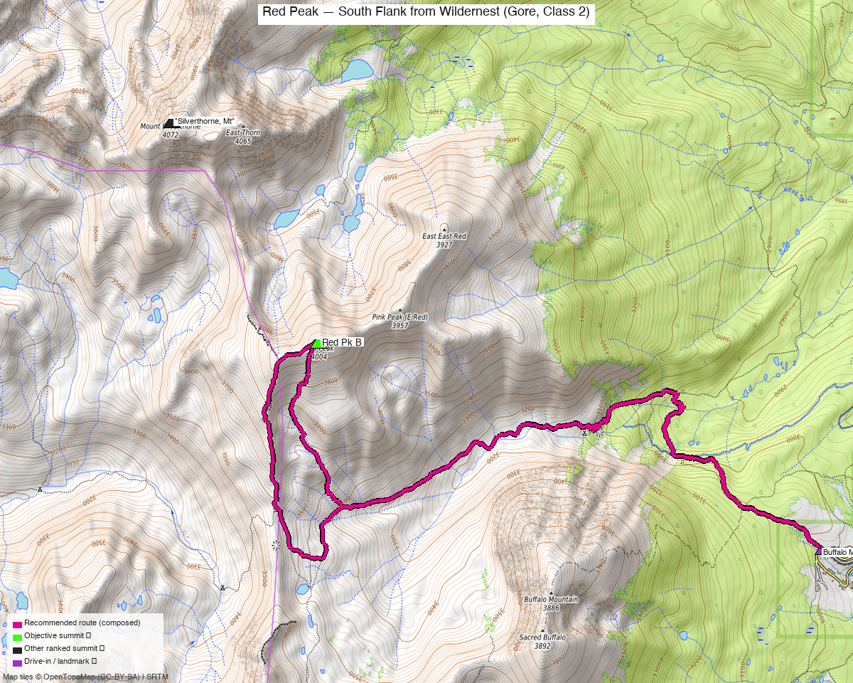
Note: the recommended route was distilled from 13 recorded GPS tracks of real trips (14ers.com · ListsofJohn · peakbagger) — all layered on the interactive CalTopo research map.
Peaks covered
Red Peak sits on the main crest of the Gore Range above South Willow Creek and the Willow Lakes basin, inside the Eagles Nest Wilderness of the White River National Forest (Summit County, Willow Lakes USGS quad). LiDAR shaved 3' off the map figure (13,189' → 13,186') but its Colorado rank held at #494. Line-parent and proximate parent per LoJ is Mt Silverthorne, 1.54 mi north on the same ridge; prominence is 932' and LoJ/peakbagger isolation is 1.25–1.55 mi — small numbers reflecting how tightly this summit is packed against Silverthorne. No permits or fees are required, dogs allowed, standard Eagles Nest Wilderness rules apply (leashes advised, no mechanized travel, respect wilderness camping regs off-trail).
| Peak | Elev | Class | CO rank | Status |
|---|---|---|---|---|
| Red Pk B | 13,186' | 2 | 494 | unclimbed |
Recommended route — the recommended line ⭐
11.8 mi · ~3,986 ft, Class 2 — an honest out-and-back from the Buffalo Cabin TH: maintained trail (Buffalo Mountain Trail → South Willow Creek → Gore Range Trail) for the majority of the distance, then off-trail up an open drainage into the basin south of Red Peak and up the south flank on tundra and boulder talus to the summit. No exposure, no scrambling, no routefinding on the standard line. The one thing to plan for is a ~400' descent from the Buffalo Mtn Trail junction down into South Willow Creek that you have to re-climb on the return — this day is not a downhill finish. climb13ers offers an optional west-then-south descent variant off the summit ridge down to Red Buffalo Pass, same Class 2, that closes a small summit-end loop. Recorded RTs at this TH cluster 12.0–14.2 mi (seven usable summer/shoulder recordings across the three sources); the composed 11.8 mi line sits at the shortest end.
Route sequence
- Buffalo Cabin TH (9,775') — signed as the northern of two THs at the top-of-Wildernest lot. Head WNW on the Buffalo Mountain Trail through beetle-kill lodgepole, gaining ~200' in the first ~0.75 mi.
- Buffalo Mtn junction (~10,000') — a signed left goes up Buffalo; stay straight. The trail levels, then drops NW toward South Willow Creek along an old ditch line (steep in places, can be muddy).
- South Willow Creek bridge (~9,600') — solid crossing at the low point; climb briefly to meet the Gore Range Trail heading west up-valley.
- Waterfall switchbacks (~10,400') — first ~1 mi of the Gore Range Trail is rocky and steady, switchbacking above a waterfall before easing into the upper basin at treeline.
- Leave the trail (~11,500') — as the Gore Range Trail begins to swing SW toward Red Buffalo Pass, break off northwest up an open drainage on the east side of Red Peak's south ridge. Expect snow patches into mid-July.
- South-flank bench (~12,200') — a broad tundra bench under the summit block; earlier-season snow shows here.
- Red Peak summit (13,186') — ~1,000' of boulder-talus ascent directly up the south flank. No register, small rock shelter, big views south down to Dillon and along the Gore crest.
- Return — reverse the line back to the TH (about 5.9 mi), or drop the west-then-south descent ridge to Red Buffalo Pass, pick up the Gore Range Trail, and rejoin the ascent line above the waterfall. Either way, budget the ~400' re-climb out of South Willow Creek back up to the Buffalo Mtn Trail on the way home.
Getting there — Buffalo Mtn - Lily Pad Lake TH (Buffalo Cabin TH) (9,775')
| Drive from Boulder | ~2h 35m via Google Maps |
| Trailhead | Buffalo Mtn - Lily Pad Lake TH (Buffalo Cabin TH), 39.62022, -106.10983, 9,775' |
| Road | Paved neighborhood streets the whole way — I-70 Exit 205 (Silverthorne/Dillon), N on HWY 9 to the first light, W on Rainbow Dr/Wildernest Rd → Ryan Gulch Rd for 3.6 mi to the lot at the top. climb13ers rates it "Passenger Car Accessible." Popular TH; lot can fill on summer weekends — arrive early. No restrooms at the TH; no overnight camping in vehicles (condos immediately adjacent). |
| Land | White River National Forest / Eagles Nest Wilderness. No permits or fees for day use; standard wilderness rules (leashed dogs, no wheels, LNT). Nearest developed camping is on HWY 9 north — Blue River CG, then Green Mtn Reservoir. |
Gear & season
- Prime window: late July through late September. Recorded summer/shoulder tracks at this TH cluster in July–early October (five of seven usable recordings are July–September); the south-facing 12,200' bench holds snow into mid-July and the upper basin holds it later. climb13ers' own photos are from July 23 with large snowfields still in the basin.
- Off-season: May–June is a snowshoe/ski undertaking, not a walk-up. Two winter tracks in the sweep (a ski line from Willowbrook 2019-04 and a 2020-04 ascent from Buffalo TH) confirm the season, and both were rejected from the recipe on that basis.
- Gear: ordinary hiking kit for peak season — poles help on the ~400' re-climb out of South Willow Creek. Ice axe recommended by climb13ers for the upper basin/south-flank snow in earlier season; carry it if you're going before late July. Traction (microspikes) is worth having through mid-July.
- Storms: standard Colorado summer pattern — off the summit by noon. The last 1,000' on the south flank is fully exposed boulder-talus with nowhere to shelter, and the return crosses a broad tundra bench before dropping back to trail.
- Cell: decent LTE at the TH (Wildernest neighborhood); expect to lose it once you drop into South Willow Creek and again in the upper basin. Summit is line-of-sight to Dillon and often gets a weak signal.
Other considerations
- Same-TH combo option: Mt Silverthorne (13,361', Class 2, 1.54 mi N on the same ridge) is Kyle's other unclimbed 13er reachable directly from this lot — the Buffalo Cabin TH accesses both. A two-day car camp (or two separate day trips, drive is only ~2.5 h) could take both back-to-back. Not a linkup on the same day: the connecting Zodiac Ridge and the Red–Silverthorne traverse are not on any candidate recorded segment, and climb13ers explicitly flags the Red→"Pink Peak" (unranked, 12,983') connect east as "possibly 4th class or higher" — so plan them as separate one-per-day objectives.
- Do NOT try to link Red → Pink on the summit: climb13ers describes the connecting ridge east to Pink as "daunting - possibly 4th class or higher" and did not attempt it. Anyone wanting Pink is told to drop back down to the trail and re-ascend — Red Peak itself stays Class 2 for that reason.
- Alternate approaches, all longer / non-standard: Gore Creek Campground on the Vail side is a ~5–6 mi-longer day up Gore Creek Trail (one 18.9 mi shoulder-season track in the sweep makes the summit; a 16.8 mi summer track does not). Meadow Creek TH on the Frisco side yields only a one-way car-shuttle line. Willowbrook TH N of Silverthorne is a winter ski line. None of these are standard summer routes to Red Peak; the Buffalo Cabin TH is the pick.
- Descent variant vs straight out-and-back: climb13ers' west-then-south descent ridge back to Red Buffalo Pass adds interest and is the same Class 2; either is fine. The variant closes a small summit-end loop; the true main-day shape is out-and-back regardless.
- Not a far-from-home report: drive is ~2.5 h from Boulder — well under the 4 h combined-trip trigger. No need to pair with anything outside the area to justify the drive.
Trip reports & GPX (all three sources)
Sources confirmed logged in: 14ers.com ("Basin"), listsofjohn.com ("letsgocu"), peakbagger.com ("Kyle Knutson"). All three swept fresh for this build, plus the mapped OSM trails in the bbox — all layered on the research map.
-
14ers.com: 4 track(s) harvested from the Red Pk B gpxlib page — three summer/shoulder RTs from Buffalo Cabin TH (2022-07, 2024-10, 2025-09; the 2025-09 file
trk_14ers_3at 12.0 mi is the shortest and densest and became the recipe base) plus one 2020-04 winter ski line rejected on season. -
listsofjohn.com: 5 track(s) harvested from peak/618 trip reports — two clean summer RTs from Buffalo TH (2019-07, 2025-07, both kept as per-leg candidates), a 2016-10 shoulder-season RT from Gore Creek Campground on the Vail side (18.9 mi, alternate approach for Vail-side climbers), a 2019-04 winter/ski line from Willowbrook (rejected on season), and one undated drawn CalTopo trace of the standard line (rejected — no per-point timestamps;
check_route_sourcesfails drawn lines). -
peakbagger.com: 5 unique tracks harvested from pid 5775 ascents (+5 more deduped as duplicates of 14ers/LoJ files) — one long summer RT from Buffalo TH (2024-07, 18.4 mi with extra exploration), one summer Vail-side attempt that did not summit (2022-07), a 2025-09 Frisco-side one-way car-shuttle line, an undated drawn Willow Lakes/Silverthorne link (rejected — drawn, one-way), and a 2021-08 descent-only fragment starting mid-mountain at Red Buffalo Pass (unusable as a base). Buffalo TH remains the standard summer approach across all three sources.
Sources checked: 14ers.com ✓ (logged in, "Basin") · listsofjohn.com ✓ (logged in, "letsgocu") · peakbagger.com ✓ (logged in, "Kyle Knutson")