Keller Mountain (13,080', Rock Creek, Gore) — East Ridge
Other climbers: Emily Sharpe — not yet · Shawn D Keil — ✓ climbed
At a glance — recommended day
9.3 mi · 3,836 ft gain · Class 2 · 1 peak · ~2.77 h drive
NOAA weather link: Keller Mountain (13,080', Rock Creek, Gore) — East Ridge Weather
Drive from Boulder: ~2h 50m via Google Maps
CalTopo research map: https://caltopo.com/m/CP10183
Researched: 2026-08-06
Status in Peak Checklist: unclimbed. Keller anchors the Rock Creek pocket of the Gore list — one of 15 unclimbed 13ers within six miles — and at under 3 hours from Boulder with a 9-mile Class 2+ day, it's one of the easiest remaining Gore ticks to bag on short notice.
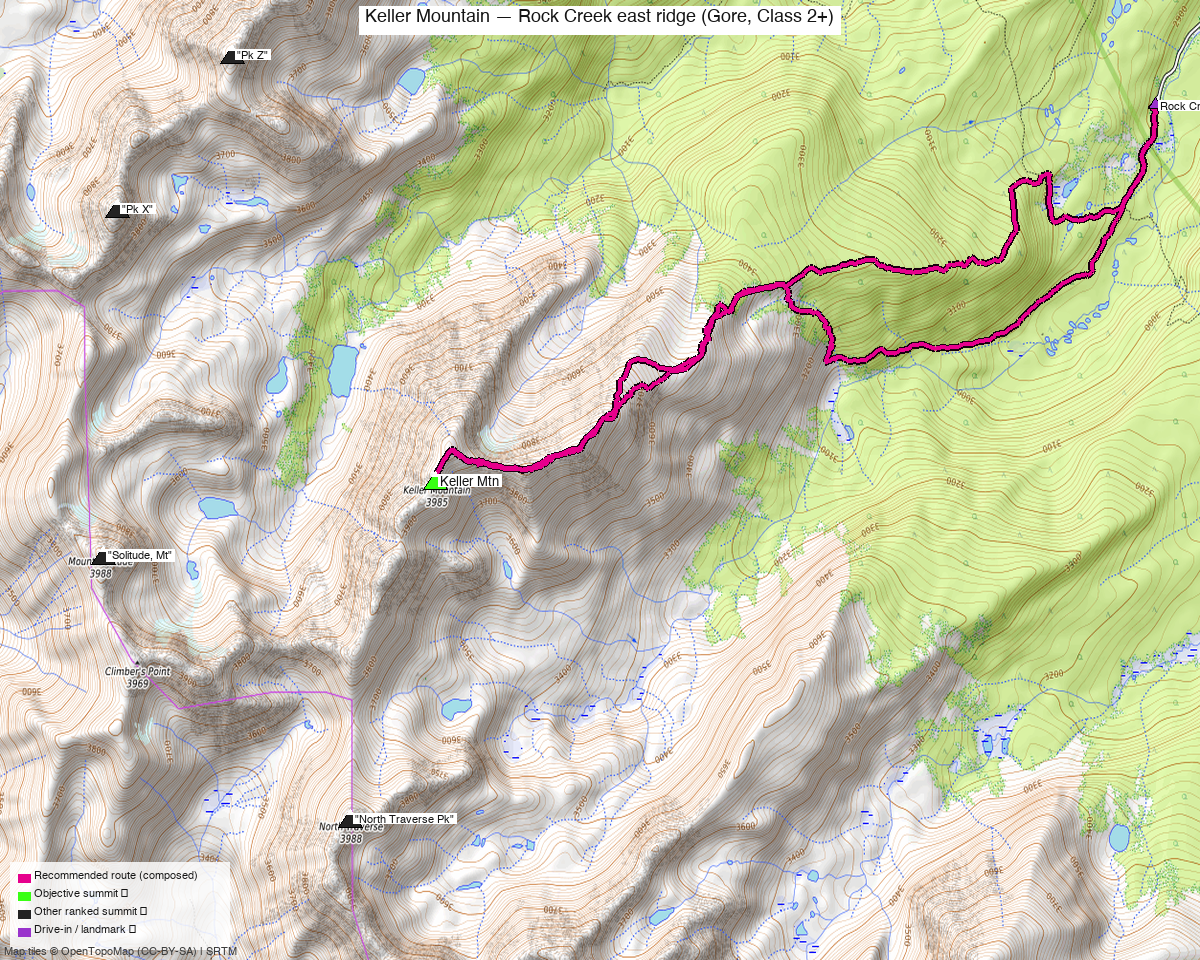
Note: the recommended route was distilled from 8 recorded GPS tracks of real trips (14ers.com · ListsofJohn · peakbagger) — all layered on the interactive CalTopo research map.
Peaks covered
Keller Mountain stands at the head of Rock Creek on the east side of the Gore Range, inside the Eagles Nest Wilderness (White River National Forest, Dillon Ranger District). LiDAR shaved five feet off the old 13,085' figure. No permits or fees — just the standard wilderness self-registration at the trailhead. Its neighbors on the map (Pk Z, Pk X, Mt Solitude, North Traverse Pk) are climbed from other drainages and have their own reports; from Rock Creek, Keller is the objective.
| Peak | Elev | Class | CO rank | Status |
|---|---|---|---|---|
| Keller Mtn | 13,080' | 2+ | 584 | unclimbed |
Recommended route — the recommended line ⭐
9.3 mi · ~3,836 ft, Class 2+ — the East Ridge from Rock Creek, the beta-standard day and the shape every recorded party used: trail up the Rock Creek drainage for the first two miles, then a rising line onto the broad east ridge and a long ridge walk west to the summit. The line is composed from the freshest summer recording (August 2025, LoJ) with its side-spurs trimmed, out and back on the same ground — climb13ers calls this route 9 mi / 3,610', and the composed line lands at 9.3 / 3,836. Stay on the ridge for the descent: dropping off it early means a genuinely bad bushwhack through beetle-kill deadfall.
Route sequence
- Rock Creek TH (9,465') — end of Rock Creek Road north of Silverthorne; parking is extremely limited, so arrive early.
- Rock Creek Trail, ~2 mi — good trail southwest through forest up the drainage (old Boss Mine corridor), to ~10,500' where the recordings leave the trail near the trail's bend.
- Gain the east ridge (~11,500') — climb southwest out of the drainage onto the broad ridge crest; the forest thins quickly and the rest of the day is open.
- East ridge to the summit (13,080') — a long, gradually steepening ridge walk west on tundra then blocky Gore talus; the recordings hold the crest the whole way. Class 2+, with harder scrambling available but avoidable.
- Return — retrace the ridge and trail. Resist any shortcut down into Rock Creek before the trail junction — the beetle-kill bushwhack below the ridge is the route's one real trap.
Getting there — Rock Creek TH (N of Silverthorne) (9,465')
| Drive from Boulder | ~2h 50m via Google Maps |
| Trailhead | Rock Creek TH (N of Silverthorne), 39.71115, -106.16705, 9,465' |
| Road | CO-9 north of Silverthorne to Rock Creek Road (OSM: unpaved) — ~1 mi of dirt to the parking pull-off; climb13ers rates it passenger-car accessible. Parking is extremely limited — a handful of spots at the road end. |
| Land | White River National Forest (Dillon RD); the route enters the Eagles Nest Wilderness on the trail. No permits or fees; wilderness self-registration at the TH. |
Gear & season
- Window: July–September, with a real October shoulder. The library splits cleanly: three August recordings (2014, 2020, 2025 — the route source), two October lines (2011, 2020) showing the ridge stays feasible late, and one February ski line that is a different objective entirely.
- Class 2+ ridge — tundra then blocky Gore talus; no exposure that demands a helmet or rope, but the "2+" is honest talus work, and harder scrambling is there if you want it.
- The bushwhack trap, not the ridge, is the hazard. Every source repeats it: leave the east ridge early on the descent and you're in beetle-kill deadfall. Stay on the crest to the trail.
- Standard Gore storm rules — the last 2.5 miles are open ridge with no bail options except back the way you came; be off the crest by early afternoon in monsoon season.
- Cell service is intermittent this close to Silverthorne but don't count on it in the drainage.
Other considerations
- Same trailhead as Pk Q + Peak R. The Pk Q + Peak R report starts from this exact TH — a different, much harder (Class 4) day deeper up the drainage. Keller is the short companion objective out of Rock Creek; two separate visits, not one push.
- The North Traverse Peak combo is moot — climb13ers suggests pairing Keller with North Traverse, but that one's already climbed; the connecting ridge adds nothing to the list.
- The Bighorn Creek (Vail) approach is the other standard line — 13.2 mi / 4,975' Class 2+ via the south ridge, longer and from the wrong side for a Boulder start. Rock Creek is the right answer.
- The 15.8-mi one-way traverse recording (Aug 2025) exits over the range to the Vail side — evidence the bigger link-up exists, but it needs a shuttle and buys no unclimbed peaks.
Trip reports & GPX (all three sources)
Sources confirmed logged in: 14ers.com ("Basin"), listsofjohn.com ("letsgocu"), peakbagger.com ("Kyle Knutson"). All three swept fresh for this build, plus the mapped OSM trails in the bbox — all layered on the research map.
-
14ers.com: 2 track(s) harvested. Peak page (peakid 10240) GPX library gave an October 2011 shoulder line and a February 2021 winter/ski line — neither used for the summer route, both useful season evidence.
-
listsofjohn.com: 3 track(s) harvested from 4 trip reports checked. The August 2025 recording (gpx 18015) is the recommended line's source; the others are an August 2014 round trip (gpx 966) and an undated round trip (gpx 2915). LoJ's peak page also cross-confirmed the peakbagger pid (33066) — no Gladstone-style id mismatch.
-
peakbagger.com: 3 track(s) harvested (pid 33066, cleared Cloudflare without a manual click). An August 2025 round trip, an October 2020 shoulder round trip, and a partial descent recording starting on the summit ridge.
Sources checked: 14ers.com ✓ (logged in, "Basin") · listsofjohn.com ✓ (logged in, "letsgocu") · peakbagger.com ✓ (logged in, "Kyle Knutson")