Pk Q + Peak R — Rock Creek (Gore, Class 4)
Other climbers: Emily Sharpe — not yet · Shawn D Keil — not yet
At a glance — recommended day
19.89 mi · 6,232 ft gain · Class 4 · 2 peaks · ~2.52 h drive
NOAA weather link: Pk Q + Peak R Weather
Drive from Boulder: ~2h 31m via Google Maps
CalTopo research map: https://caltopo.com/m/KUA0VBJ
Researched: 2026-07-27
Status in Peak Checklist: both unclimbed. Pk Q (13,239', "Prisoner Peak") is the hardest and most remote objective in the remaining Gore set, paired here with its neighbour Peak R (13,000') 0.49 mi away. This is the one report of the seven that is genuinely serious — read the danger box before committing.
Combination Options: - This report IS the combination, and both the beta and the tracks agree. climb13ers: "Climbing Peak Q from the Slate Creek side will also present an opportunity to climb Peak R." 3 of the 7 swept tracks bag both peaks, and Peak R's only recorded track is one of them — nobody goes there on its own. - Same trailhead as Keller Mtn (Rock Creek) — two reports from one parking lot, though these are opposite ends of the effort scale. - The backpack is a legitimate alternative, not a cop-out. climb13ers considers Pk Q a backpack objective: either "into the Slate Creek area from the east side of the Gore, a lengthy pack trip of three days minimum," or from Pitkin Lake. One swept track does both peaks in just 8.1 mi from a 10,904' camp — so if you'd rather not do a 20 mi day with Class 4 in the middle of it, camping high turns this into a short, focused summit day. - Pitkin Creek is the other trailhead — the west-side approach, 20.0 mi for both peaks (essentially the same as Rock Creek) and the side climb13ers used for Pk Q alone (17.4 mi / 6,760'). It's also the trailhead for The Partners and Pk Z + Pk X + Mt Solitude.
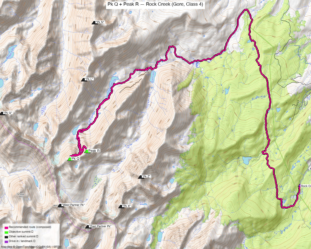
Note: the recommended route was distilled from 6 recorded GPS tracks of real trips (14ers.com · ListsofJohn · peakbagger) — all layered on the interactive CalTopo research map.
Peaks covered
Pk Q is Class 4 — possibly low 5th — remote, loose, and hard to find help on
climb13ers on the NE Face: "a rugged Class 4 (some, desiring rope, may consider as low Class 5) ascent with some exposure." Exposure moderate in short sections, steepness rated "Don't Look Down!", terrain listed as boulder talus, rubble, stacked boulders and "Watch for Falling Mountains" (i.e. genuinely loose), routefinding Difficult, ice axe recommended. It is "one of the most remote of all the Gore summits" and they warn: "if you are injured, someone else finding you may take days."
They also say outright: "Do your homework before attempting this summit by consulting other reports besides ours." Treat that as instruction, not boilerplate — helmet mandatory, partner strongly advised, InReach non-negotiable, and be willing to turn around.
| Peak | Elev | Class (route) | Notes | peak_db |
|---|---|---|---|---|
| "Pk Q" / "Prisoner Peak" | 13,239' | 4 (NE Face) | the crux of the day; LiDAR added 9 ft | 563 |
| Peak R | 13,000' | 2 | climb13ers: "just 5 feet short of being a 13er" — LiDAR/peak_db rank it 637, so it counts | 819 |
Both sit in the Eagles Nest Wilderness (White River NF) — no permits or fees, standard wilderness rules. Peak R is the consolation prize: an easy walk once you're up there, which is exactly why every party that gets Q takes it too.
Getting there — Rock Creek (north of Silverthorne)
Drive from Boulder: ~2h 31m via Google Maps (origin: 1162 Peakview Circle) — I-70 W to Silverthorne (exit 205), north on CO-9, then west on Rock Creek Road. 97.6 mi.
| Trailhead — Rock Creek | ~39.71115,-106.16705, 9,465'. Passenger-car accessible; the last stretch of Rock Creek Road is unpaved. Same trailhead as the Keller Mtn report. |
| Trail | Rock Creek / Gore Range Trail system, then up into the Slate Creek drainage side toward Pk Q's north-east flank. |
| Alternative TH | Pitkin Creek (East Vail), ~39.64288,-106.30318, ~8,430' — 20.0 mi for both peaks, and climb13ers' choice for Pk Q alone. |
Route — Rock Creek to Pk Q's NE face, then Peak R (Class 4)
~19.9 mi · ~6,232 ft round trip — the recommended line follows an October 2025 recording verbatim, the east-side both-peaks day: it starts 30 m from the researched trailhead, is essentially gap-free (max-gap 0.03 mi), and takes Pk Q first, then Peak R:
- Rock Creek trail system from 9,465' — the long approach in. This is the bulk of the mileage and the reason the day is 20 mi.
- Into the upper basin below Pk Q's north-east side — off trail, on talus and rubble.
- Pk Q's NE Face — the crux (Class 4). Rugged, loose, moderately exposed in short sections, with difficult routefinding. Beta is thin; expect to choose your own line and to downclimb what you climbed. This is where the day is won or abandoned.
- Peak R (Class 2) — 0.49 mi away and easy by comparison. Cheap to add once Q is done, which is why all three both-peaks parties did exactly this.
- Reverse the approach back down Rock Creek.
Order matters: Q first, while fresh and with the whole day in hand. The one recorded party that did R first was working from a high camp, not a trailhead.
Gear & season
- Best window: mid-July through September. climb13ers recommends an ice axe; the NE face is a north-ish aspect that holds snow late.
- Gear: helmet mandatory ("Watch for Falling Mountains"). Ice axe in early season. climb13ers notes some parties want a rope on Pk Q and would call it low Class 5 — if you're not comfortable soloing sustained Class 4 downclimbing on loose rock, bring one.
- Season caveat, stated plainly: there is no summer trailhead-to-summit recording in the pool for the pair. Both trailhead-based both-peaks tracks are October shoulder-season (this route's is October 2025; the Pitkin one is October 2024), and the only July track starts from a 10,904' camp. The line itself is a walking/scrambling route rather than a snow-dependent one, so it holds up as a summer route — but you'd be the one verifying summer conditions on the NE face rather than following a summer track.
- Remoteness is the real hazard. Days-to-rescue territory per climb13ers. InReach, a partner, and a hard turnaround time.
- Cell: assume none.
Other considerations
This is a 20 mi day with Class 4 in the middle of it. Two recorded parties have done exactly that from a trailhead, so it goes — but the honest framing is that the approach eats most of your energy before the hard climbing starts. Of the seven remaining Gore reports this is by far the most committing.
If any of the seven deserves the backpack treatment, it's this one. 8.1 mi for both peaks from a 10,904' camp versus 19.9 mi from the road. Camping high means arriving at the Class 4 fresh, with daylight in reserve and a shorter retreat if the face doesn't feel right. climb13ers frames Pk Q as a backpack objective for precisely this reason (Slate Creek, three days minimum, or Pitkin Lake). Say the word and this can be rebuilt as a multi-day trip.
Peak R is a bookkeeping peak, and that's fine. climb13ers barely covers it — "just 5 feet short of being a 13er" — but LiDAR and peak_db rank it at 13,000', so it's on your list, and its only recorded track is a Pk Q day. There is no reason to ever visit it separately.
You've already scouted this face — your own lines are on the map. Six tracks pulled from
your regional CalTopo map are drawn here in blue, and their names are the giveaway:
potential-route-to-peak-q, better-ascent-gully, notch-1-gully,
actual-route, rockinghorse-ridge and rockinghorse-ridge-with-corey. On a peak where
climb13ers says beta is thin and to consult other sources, your own gully options are the most
specific information available — start there rather than from scratch.
Do the homework climb13ers asks for. Thin beta on a loose, remote Class 4 face is the combination that turns into an epic. The CalTopo map has all 7 swept tracks layered on it — including the three both-peaks lines from three different starts — which is the most useful thing here: compare how different parties actually tackled the face.
Trip reports & GPX (all three sources)
Sources confirmed logged in: 14ers.com ("letsgocu"), listsofjohn.com ("letsgocu"), peakbagger.com ("Kyle Knutson"). Both peaks' libraries were swept across all three sources and deduped — 7 recorded tracks — plus 6 of your own CalTopo lines for this terrain (see below) and the full OSM trail network (33 mapped ways in the Rock Creek / Slate Creek / Pitkin drainages). All 13 tracks are layered on the CalTopo map.
- 14ers.com: peak pages "Peak Q" (10224), Peak R (10874) — 3 tracks (one trip-report attachment, two GPX-Library uploads), including the 20.0 mi Pitkin-side both-peaks day.
- listsofjohn.com: Pk Q (563), Peak R (819) — 7 trip reports between them, 3 with downloadable GPX (one is a March winter line on Pk Q, not used); both cross-link the correct peakbagger pids.
- peakbagger.com: Pk Q pid 59110 (3 ascents), Peak R pid 19761 (2 ascents) — 1 GPX track after dedup: the same party logged both summits from one outing, which is the October 2025 recording the route is built from.
- climb13ers.com: Peak Q NE Face (Class 4, the danger-box source, and the Slate-Creek Q+R pairing note).
- Your own prior lines (pulled from the regional CalTopo map, drawn in blue):
potential-route-to-peak-q,better-ascent-gully,notch-1-gully,actual-route,rockinghorse-ridge,rockinghorse-ridge-with-corey. You have clearly scouted this face before — those gully options are the most specific beta on the map.
Sources checked: 14ers.com ✓ (logged in, "letsgocu") · listsofjohn.com ✓ (logged in, "letsgocu") · peakbagger.com ✓ (logged in, "Kyle Knutson")