Pk Z + Pk X + Mt Solitude — Pitkin Lake basin (Gore, Class 2+)
Other climbers: Emily Sharpe — not yet · Shawn D Keil — 1 of 3 (Mount Solitude)
At a glance — recommended day
15.53 mi · 7,446 ft gain · Class 2+ · 3 peaks · ~2.67 h drive
NOAA weather link: Pitkin Lake basin Weather
Drive from Boulder: ~2h 40m via Google Maps
CalTopo research map: https://caltopo.com/m/TK294GM
Researched: 2026-07-27
Status in Peak Checklist: all three unclimbed. Three ranked 13ers ringing the Pitkin Lake basin in the Eagles Nest Wilderness above East Vail — Pk Z (13,227', aka "Gorgeous Peak"), Pk X (13,094') and Mt Solitude (13,085'). No exposure to speak of, but a big day: 7,446 ft of gain, the most of any single-day Gore report here.
Combination Options: - This report IS the combination — one clean recorded track (Sept 2024, max-gap 0.03 mi) bags all three in a single 15.5 mi push, and climb13ers documents Pk Z "CLIMBED WITH PEAK X" via Usable Pass. Adding Solitude costs surprisingly little extra distance. - Same trailhead as The Partners (Pitkin Creek) — so these two reports together cover 5 ranked 13ers from one parking lot on separate days. - Pitkin Lake basecamp → six 13ers. climb13ers recommends camping either at the lower Pitkin Creek campsite or up at Pitkin Lake to collect these three plus both Partners and Pk Q "in just a few days." As day trips (your preference) this is one outing; as a backpack it merges with the Partners report.
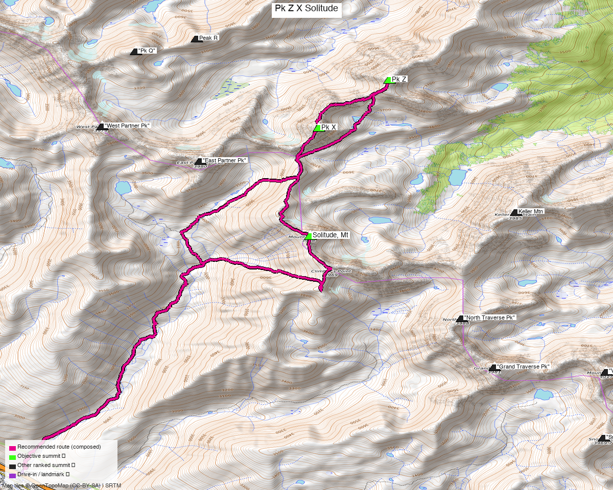
Note: the recommended route was distilled from 11 recorded GPS tracks of real trips (14ers.com · ListsofJohn · peakbagger) — all layered on the interactive CalTopo research map.
Peaks covered
Three Class 2+ Gore summits — tundra, boulder talus, scree and (on Solitude) some willow-bashing. The difficulty here is volume, not terrain: minimal exposure and easy routefinding on all three, but ~15.5 mi with ~7,450 ft of gain.
| Peak | Elev | Class (route) | Solo/pair from TH (climb13ers) | peak_db |
|---|---|---|---|---|
| "Pk Z" / "Gorgeous Peak" | 13,227' | 2+ (South Ridge) | 15.2 mi / 6,285' with Pk X | 548 |
| "Pk X" | 13,094' | 2+ | (climbed with Pk Z) | 733 |
| "Mt Solitude" | 13,085' | 2+ (West Slopes) | 10.85 mi / 4,640' | 727 |
All three sit in the Eagles Nest Wilderness (White River NF), Vail East / Willow Lakes quads — no permits/fees, standard wilderness rules. LiDAR subtracted 18 ft from Pk Z. Pk X and Mt Solitude are both children of Pk Z; Pk Z's parent is Pk Q.
Getting there — Pitkin Creek (East Vail)
Drive from Boulder: ~2h 40m via Google Maps (origin: 1162 Peakview Circle) — I-70 W to East Vail (exit 180), then the frontage/Bighorn Rd to the Pitkin Creek trailhead.
| Trailhead — Pitkin Lake / Pitkin Creek | ~39.64288,-106.30318, ~8,430'. All paved, any passenger car. Small East Vail lot right off I-70 — fills early on summer weekends. |
| Trail | Pitkin Creek Trail up the drainage; the lower campsite sits ~3.75 mi in where the two branches of Pitkin Creek divide, Pitkin Lake ~4.5 mi in. |
| Note | Reaching these peaks from the east side of the range means long mileage and probably a backpack (climb13ers) — the Pitkin/west approach is the efficient way. |
Route — Pitkin Creek, Usable Pass, then the three summits (Class 2+)
~15.5 mi · ~7,450 ft round trip — the recommended line follows the one recorded September 2024 track that bags all three, verbatim (the only other multi-peak candidate in the pool was a March 2015 winter/ski line, which is the wrong terrain for a summer day):
- Pitkin Creek Trail from the trailhead up the drainage — the long approach grind past the lower campsite toward the basin.
- Over "Usable Pass" (climb13ers' name) into the upper basin.
- Pk X — talus and tundra to the 13,094' summit, minimal exposure.
- Pk Z ("Gorgeous Peak") via the connecting South Ridge — "crossing superb alpine country," Class 2+, easy routefinding; the high point of the day at 13,227'.
- Mt Solitude — back south and up its West Slopes (Class 2+, exposure None, some willow-bashing low down) to 13,085'.
- Out via the Pitkin Creek Trail.
climb13ers pairs Z+X at 15.2 mi / 6,285' and Solitude separately at 10.85 mi / 4,640' — so getting all three in 15.5 mi is an efficient line, at the cost of a lot of vertical.
Gear & season
- Best window: mid-July through September — the basin melts out late; climb13ers flags an ice axe for Pk Z in early season.
- Gear: Class 2+ — no rope or helmet demands in season. Poles are worth it: lots of talus and ~7,450 ft of up-and-down. Willows on the Solitude approach are a known nuisance — long pants earn their keep.
- Fitness, not technique, is the gate. Minimal exposure and easy routefinding, but this is among the biggest vertical days in the Gore set. Budget accordingly, or split it (Solitude alone is a 10.85 mi day; Z+X is 15.2 mi).
- Terrain: above treeline for the upper two-thirds — early start, off the ridges before the afternoon monsoon.
- Cell: patchy in the basin. Carry an InReach.
Other considerations
Three peaks for one approach. The ~4 mi of Pitkin Creek trail is the price of admission to this basin, so collecting three summits per trip is the efficient play — doing them individually would mean walking that approach three times.
Pk Q is the fourth peak in this basin, and it's covered in its own report from the Rock Creek side (the one clean recorded track pairs it with Peak R). climb13ers reaches it from Pitkin Lake instead — so if you ever do the backpack, Q folds in naturally here.
The vertical is the story. ~7,450 ft is a Nolan's-grade day of climbing for three mid-13ers. If the forecast is marginal, Solitude alone (10.85 mi / 4,640') is the natural bail-down objective.
Trip reports & GPX (all three sources)
Sources confirmed logged in: 14ers.com ("Basin"), listsofjohn.com ("letsgocu"), peakbagger.com ("Kyle Knutson"). All three peaks' libraries were swept across all three sources and deduped, plus the full OSM trail network (69 mapped ways) — layered on the CalTopo map.
- 14ers.com: peak pages "Peak Z" (10223), "Peak X" (10241), "Mount Solitude" (10239) — 2 GPX-library tracks (one is a March winter line, not used).
- listsofjohn.com: Pk Z (548), Pk X (733), Mt Solitude (727) — 15 trip reports, text only (no downloadable GPX); LoJ grades Z and X 2+.
- peakbagger.com: Pk Z pid 33060, Pk X pid 33059, Mt Solitude pid 39859 — 1 ascent GPX pulled, and it's the all-three day the route is built from.
- climb13ers.com: Peak Z South Ridge (Class 2+, climbed with Peak X) · Mt. Solitude West Slopes (Class 2+) — route + TH beta.
Sources checked: 14ers.com ✓ (logged in, "Basin") · listsofjohn.com ✓ (logged in, "letsgocu") · peakbagger.com ✓ (logged in, "Kyle Knutson")