Hunts Peak — northernmost Sangre 13er via the West Ridge (Class 2)
Other climbers: Emily Sharpe — not yet · Shawn D Keil — ✓ climbed
At a glance — recommended day
7 mi · 3,425 ft gain · Class 2 · 1 peak · ~5.05 h drive
NOAA weather link: Hunts Peak Weather
Drive from Boulder: ~5h 05m via Google Maps
CalTopo research map: https://caltopo.com/m/RNN7250
Researched: 2026-08-05
Status in Peak Checklist: climbed (2019-11-13, a November snow ascent). This rebuilt report documents the summer standard route — useful for a repeat in season, or for pointing partners at the northernmost 13er in the Sangre de Cristo.
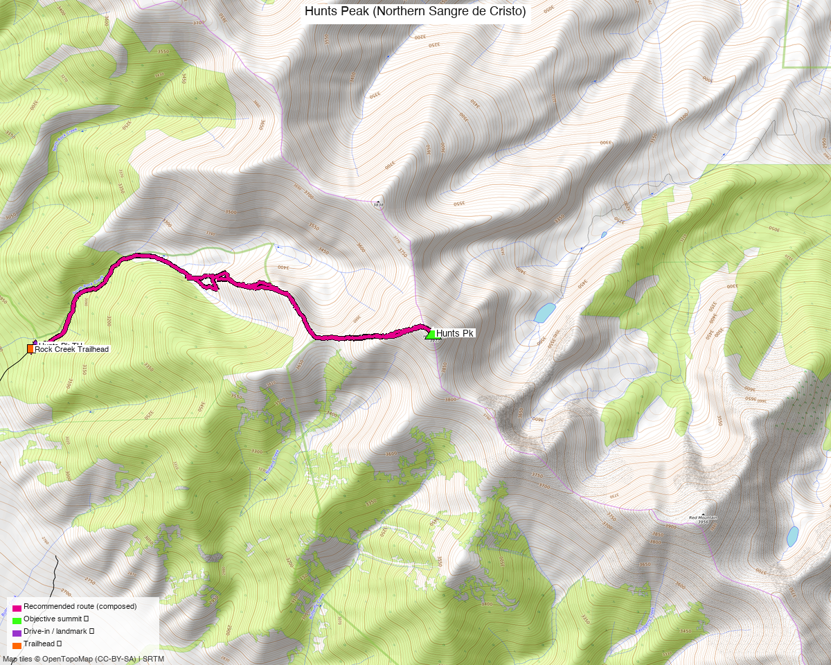
Note: the recommended route was distilled from 10 recorded GPS tracks of real trips (14ers.com · ListsofJohn · peakbagger) — all layered on the interactive CalTopo research map.
Peaks covered
One Class 2 peak — the northernmost 13er in the Sangre de Cristo Range, standing over the Arkansas Valley south of Salida.
| Peak | Elev | Class | CO rank | Status |
|---|---|---|---|---|
| Hunts Peak | 13,061' (LiDAR; pre-LiDAR 13,071') | 2 | 599 | climbed (2019-11-13) |
Fremont County, Wellsville quad — San Isabel NF on the summit, approach from the Rio Grande NF (Saguache District) side. No permits or fees.
Recommended route — West Ridge from S. Rock Creek ⭐
~7.0 mi · ~3,425 ft round trip, Class 2, up and back from the S. Rock Creek TH (9,700') on the west side of the range — composed from the one clean summer recording (July 2022); every round-trip recording in the library is a Nov–May snow line and was deliberately not used.
The line follows an old roadbed east from South Rock Creek (blocked to vehicles by a log fence; boggy in places, grasses overtaking it) that climbs steadily into a forest-fire burn area — standing bare-wood snags for much of the approach. Around 10,800' the roadbed switchbacks and fades; from there the route gains the NW/west ridge of Hunts and follows Class 2 tundra, embedded rock and rubble to the 13,061' summit. Return the same way.
Why this line: climb13ers rates the west-side day at 6.4 mi / 3,375' from this TH — our DEM-measured 7.0 mi / 3,425 ft from the recorded July line agrees closely. The east-side approaches out of the Arkansas Valley are blocked up by private property, making the nearest east trailheads 20+ mile days.
Route sequence
- From the S. Rock Creek TH (9,700'), walk down the road, cross the creek, and pick up the old roadbed climbing east (log fence across it — on foot only).
- Follow the roadbed ~1.5 mi up through the burn to its switchback near 10,800'.
- Leave the road and work up the steep embankment onto Hunts' west ridge — burned, eroding soil at first, then open tundra.
- Follow the broad Class 2 ridge east to the 13,061' summit.
- Descend the same way — the roadbed makes the burn-area forest easy to navigate on the way out.
Getting there — S. Rock Creek TH (9,700')
| Drive from Boulder | ~5h 05m via Google Maps — over Poncha Pass and up the west side of the range |
| Trailhead | S. Rock Creek TH, 38.38225, −105.98306, 9,700' (climb13ers "S. Rock Creek - SdC"; 4 recorded tracks start here) |
| Road | 4×4 with high clearance recommended (climb13ers). OSM maps the corridor (Ditch Rd / Rock Gulch Rd) as surface=unpaved, smoothness=very_bad. Without 4WD it is still doable as a longer day — one recorded party marked "drove this far" ~0.5 mi short of the TH. |
| Camping | Yes — dispersed camping near the TH (climb13ers). |
Gear & season
- Best window: July through September. ⚠️ 7 of the 10 swept recordings are Nov–May snow lines (including three complete May round trips) — those are snowshoe/ski days, not the summer route, and were deliberately excluded from the recommendation.
- Terrain: Class 2 — no exposure; tundra, embedded rock, rubble. No rope or helmet in season.
- Burn area: much of the approach is through a fire burn — expect deadfall across the old roadbed and no shade; the snags also make wind more noticeable.
- Vehicle: high-clearance 4×4 recommended for the last stretch of road.
- Storms: the ridge is open above ~11,500' — normal early start applies.
- Cell: spotty over the Arkansas Valley side; carry an InReach out of habit.
Other considerations
Nothing natural to combine from this trailhead. Hunts is the range's northern bookend — Twin Sisters North and Bushnell Peak are the next ranked summits down the crest (Kyle traversed that section over 2019-11-11/13), but they are climbed from other starts; see the Twin Sisters + "V 7" report for the South Mineral pair of the same name and the checklist for the Sangre crest neighbors. A fit party wanting more from this TH extends south along the crest toward Twin Sisters North — recorded one-way traverses exist (July 2015, 27.6 mi Hayden Pass → Salida) but they are shuttle days, not loops.
Already climbed — so why this report? The 2019 ascent was a November snow day. The rebuilt summer line is materially different (bare roadbed vs. snowshoes), and this page now carries the verified summer stats for partners or a repeat.
Trip reports & GPX (all three sources)
Sources confirmed logged in: 14ers.com ("Basin"), listsofjohn.com ("letsgocu"), peakbagger.com ("Kyle Knutson"). All three swept fresh for this rebuild, plus the 14 mapped OSM trails/roads in the bbox — all layered on the research map.
- 14ers.com: peak page 10684 — 5 GPX-library tracks (July 2022 and July 2015 summer lines; Nov 2019, Dec 2010, May 2020 snow lines).
- listsofjohn.com: peak 748 — 6 trip reports seen, 2 member tracks harvested (June 2024, July 2023) plus 1 duplicate of another source; LoJ cross-verified the peakbagger pid (5892).
- peakbagger.com: peak 5892 — 3 ascent tracks with GPS (all May snow climbs, incl. a 6.2 mi round trip on this exact route corridor).
Sources checked: 14ers.com ✓ (logged in, "Basin") · listsofjohn.com ✓ (logged in, "letsgocu") · peakbagger.com ✓ (logged in, "Kyle Knutson")