Bonita Peak + "Proposal Peak" — a short loop above Eureka Gulch (Class 2)
Other climbers: Emily Sharpe — not yet · Shawn D Keil — ✓ all
At a glance — recommended day
4.2 mi · 2,185 ft gain · Class 2 · 2 peaks · ~9.3 h drive
NOAA weather link: Eureka Gulch Weather
CalTopo research map: https://caltopo.com/m/1D180E0
Researched: 2026-08-02
Status in Peak Checklist: both unclimbed.
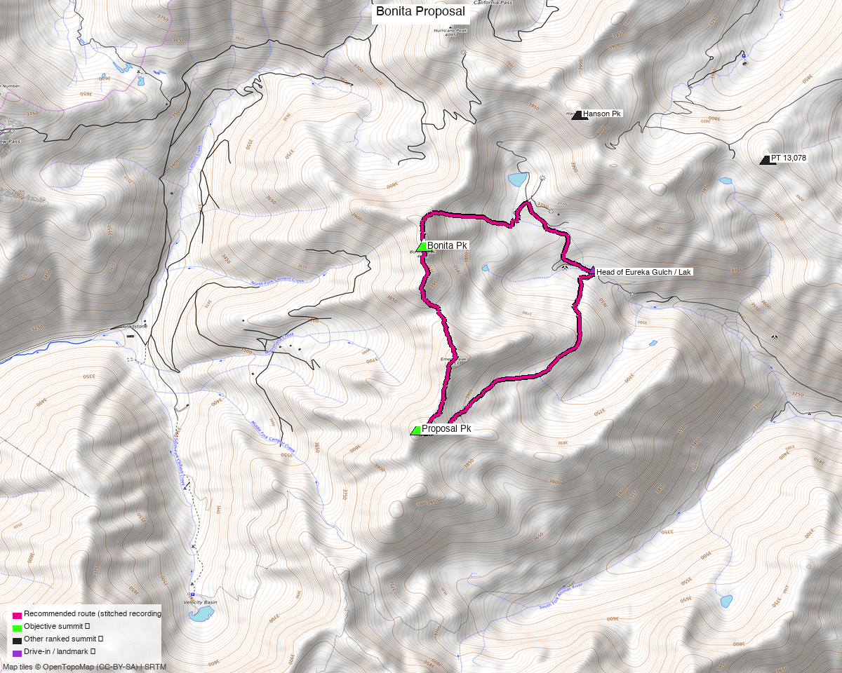
Note: the recommended route was distilled from 10 recorded GPS tracks of real trips (14ers.com · ListsofJohn · peakbagger) — all layered on the interactive CalTopo research map.
Peaks covered
| Peak | Elev | Class |
|---|---|---|
| "Proposal Pk" | 13,339' | 2 |
| Bonita Pk | 13,286' | 2 |
San Juan County — San Juan National Forest, the ridge above the head of Eureka Gulch.
The map calls this area 'Emery Peak' — that is a different summit
Between these two sits Emery Peak, 13,321', which is what most topos label here. Emery has 165 ft of prominence, below the 300 ft cut, so it is unranked and does not count toward the list. The ranked peak beside that label is "Proposal Pk".
Emery is directly on the connecting ridge and costs essentially nothing — the trip reports that do these two almost always pick it up in passing.
The recommended route — 4.2 mi / 2,185 ft
A short day, and that is the whole point of driving to 11,914 ft. Both summits sit barely a mile from the road's end, and the loop is Class 2 throughout.
Composed per leg from three different summer recordings:
| Leg | Distance | Gain | Source |
|---|---|---|---|
| TH → Proposal Pk | 1.49 mi | 1,423 ft | trk_loj_1077 |
| Proposal → Bonita | 1.28 mi | 751 ft | trk_pb_2 |
| Bonita → TH | 1.39 mi | 69 ft | trk_loj_1076 |
The descent leg is 56% on trail and gives back almost no elevation — it follows the old mining road system out of the basin rather than retracing the ascent line.
The pool ranges from 4.2 to 20.3 miles for these two summits, and the difference is entirely how far up you drive and how many other peaks the party was collecting. Several recordings link Bonita and Proposal into eight-peak Silverton mega-days; those are not this route.
Getting there — head of Eureka Gulch
| Drive from Boulder | ~9h 20m via Google Maps |
| Trailhead | Head of Eureka Gulch / Lake Emma basin, 37.89510, −107.60869, 11,914'. From Silverton take the Alpine Loop Road (CR 2), then CR 25 up the gulch. |
| Road | 4WD / high clearance, described in the beta as a standard one for this area. OSM tags the upper section surface=gravel, tracktype=grade4. No mapped trailhead or parking node — you park where the road tops out. |
| Land | San Juan NF. The access sweep found three small access=private parcels in the wider box; none touch the route. |
Gear & season
- Best window: July through September. Every recording used in this route is July or August; the two June tracks in the pool were not needed.
- Terrain: Class 2 on both summits and on the connecting ridge. Loose volcanic San Juan rock.
- Altitude: the day starts at 11,914 ft and tops out at 13,339 — there is no warm-up.
Other considerations
Emery Peak is free. 13,321', unranked, sitting on the ridge between the two objectives.
The rest of this group is deliberately unwritten. Storm Peak, "East Storm", Tower Mtn and Dome Mtn A sit on the same ridge system a few miles south and were researched alongside these two, but they do not share a trailhead with Bonita and Proposal — the sensible groupings there are still open. Nothing is published for them yet.
Two other Silverton reports exist: the Silverton five (15.8 mi, five peaks) and Little Giant (4.2 mi). At 4.2 miles this one pairs naturally with either — it is a half-day at most.
Trip reports & GPX (all three sources)
All three sources swept across both objective peaks and deduped, plus the mapped OSM trail network — all layered on the research map.
- 14ers.com: peaks 10471, 10443 — 7 GPX-library tracks (plus 1 duplicate).
- listsofjohn.com: peaks 509, 460 — 2 tracks from 11 trip reports (plus 3 duplicates). LoJ cross-verified the peakbagger ids: 19746 / 85943.
- peakbagger.com: peaks 19746, 85943 — 2 ascent tracks with GPS (plus 4 duplicates).
Sources checked: 14ers.com ✓ · listsofjohn.com ✓ · peakbagger.com ✓