Williams Mountains Traverse — 5 ranked 13ers above Lost Man Creek (Class 3)
Other climbers: Emily Sharpe — not yet · Shawn D Keil — not yet
At a glance — recommended day
13.8 mi · 5,384 ft gain · Class 3 · 5 peaks · ~4.48 h drive
NOAA weather link: Williams Mountains Weather
Drive from Boulder: ~4h 30m via Google Maps
CalTopo research map: https://caltopo.com/m/1DTDU9A
Researched: 2026-08-05
Status in Peak Checklist: all five unclimbed — this single loop clears five ranked 13ers in one push, squarely inside the 4+-peak days that make up a quarter of the log.
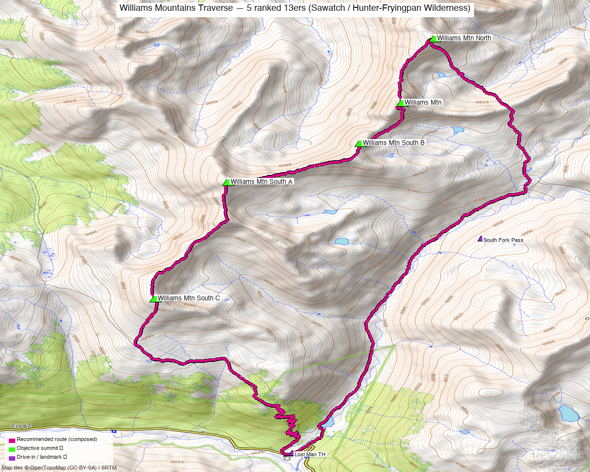
Note: the recommended route was distilled from 6 recorded GPS tracks of real trips (14ers.com · ListsofJohn · peakbagger) — all layered on the interactive CalTopo research map.
Peaks covered
Five ranked 13ers on one ridge — the Williams Mountains, the quiet crest east of Aspen in the Hunter-Fryingpan Wilderness, White River NF. No permits or fees.
| Peak | Elev | Class | CO rank | Status |
|---|---|---|---|---|
| Williams Mtn (Williams Mountains HP) | 13,390' | 3 | 329 | unclimbed |
| Williams Mtn South A (William BM) | 13,321' | 2 | 377 | unclimbed |
| Williams Mtn South B | 13,204' | 3 | 489 | unclimbed |
| Williams Mtn North | 13,139' | 2 | 538 | unclimbed |
| Williams Mtn South C | 13,039' | 2 | 614 | unclimbed |
Recommended route — the full five-summit loop ⭐
~13.8 mi · ~5,384 ft, Class 3, a loop from the Lost Man TH (10,500') on Hwy 82 — composed from two summer recordings (July 2024 + August 2017) of the same traverse. Every full-coverage recording in the library walks this exact crest; four independent parties, identical summit-to-summit line, all in summer or early fall.
From the TH the route climbs out of the Lost Man valley to gain the ridge, then works the crest over all five summits, with the Class 3 ground concentrated on the HP block (13,390') and the 13,204' (South B) block — the rest is Class 2 tundra and talus walking. The line as drawn runs the loop north-first (North → HP → South B → South A → South C); the recorded parties all walked it south-first (South C up first, North last). It is the same recorded ground in either direction — pick south-first if you'd rather take the Class 3 blocks on ascent the way every recorded party did, and treat the drawn direction as the mirror of the same day.
Route sequence (as drawn; reverse for the recorded direction)
- From the Lost Man TH (10,500'), head up the Lost Man drainage and gain the north end of the crest.
- Williams Mtn North (13,139') — Class 2.
- South along the crest to the Williams Mountains HP (13,390') — the first Class 3 block.
- Continue to South B (13,204') — the second Class 3 block.
- South A / William BM (13,321') — Class 2.
- South C (13,039'), then descend back into the valley and close the loop at the TH.
Recorded whole-days on this traverse ran 13.6–18.1 mi depending on line choices; the composed 13.8 mi sits at the efficient end of that band, on recorded ground throughout.
Getting there — Lost Man TH (10,500')
| Drive from Boulder | ~4h 30m via Google Maps — over Independence Pass |
| Trailhead | Lost Man TH, 39.12189, −106.62414, ~10,500' — a named, OSM-mapped paved-highway parking area on Hwy 82; all six recorded tracks start here |
| Road | Paved (Hwy 82) — no clearance question at all. The catch is seasonal: Independence Pass closes in winter (typically Nov–May), and the TH is on the pass road — this is a summer/fall objective by access, not just by conditions. |
| Wilderness | Hunter-Fryingpan Wilderness (White River NF) — no permits/fees; standard LNT. |
Gear & season
- Best window: July through September — 5 of the 6 recordings are July/August; one October day shows the shoulder works in a dry year. Hwy 82 closure brackets the season regardless of snowpack.
- Terrain: Class 3 on the HP and South B blocks; Class 2 ridge otherwise. Helmet sensible for the scrambling; no rope.
- Direction: both directions are recorded ground; all four full-traverse parties went south-first. See the route note above.
- Storms: ~14 mi with the whole midday on an exposed crest — start early; the ridge has few quick escapes back into the Lost Man drainage once you're on the northern blocks.
- Cell: assume dead behind the Continental Divide side; carry an InReach.
Other considerations
Five ranked peaks, one push — that's the whole pitch. All five are unclimbed, the loop is 13.8 mi from a paved trailhead 4½ hours away, and there is no shorter way to any of them that doesn't leave the rest stranded: parties who did one-peak days out of this valley each drove back for the rest. Do it once, do it whole.
Nearby but separate: the Lost Man valley also accesses the Independence Pass area 13ers to the south and east, but nothing links to this crest at ridge level — the Williams group stands alone across the Lost Man drainage.
Trip reports & GPX (all three sources)
Sources confirmed logged in: 14ers.com ("Basin"), listsofjohn.com ("letsgocu"), peakbagger.com ("Kyle Knutson"). All three swept fresh for this rebuild, plus the 19 mapped OSM trails in the bbox — all layered on the research map.
- 14ers.com: peak page 10756 (+ the four sub-peak pages) — 2 GPX-library tracks: a full-traverse October 2022 day and a sparse-but-complete August 2017 recording.
- listsofjohn.com: peaks 411 / 474 / 609 / 705 / 789 — 12 trip reports seen, 3 member tracks harvested (incl. the July 2024 full traverse the route is built from); LoJ cross-verified all five peakbagger pids.
- peakbagger.com: peaks 16642 / 16235 / 15859 / 84726 / 84732 — 1 ascent track with GPS (July 2024, full traverse).
Sources checked: 14ers.com ✓ (logged in, "Basin") · listsofjohn.com ✓ (logged in, "letsgocu") · peakbagger.com ✓ (logged in, "Kyle Knutson")