Treasure + Treasury Mountain — a Paradise Divide loop (Class 2)
Other climbers: Emily Sharpe — not yet · Shawn D Keil — not yet
At a glance — recommended day
10.1 mi · 4,113 ft gain · Class 2 · 2 peaks · ~6.65 h drive
NOAA weather link: Paradise Divide Weather
CalTopo research map: https://caltopo.com/m/KGFPN5H
Researched: 2026-08-02
Status in Peak Checklist: both unclimbed.
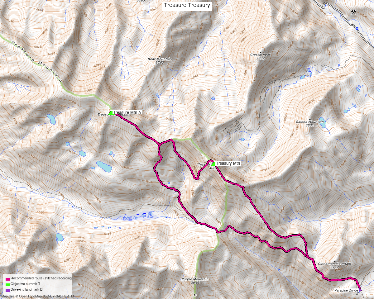
Note: the recommended route was distilled from 14 recorded GPS tracks of real trips (14ers.com · ListsofJohn · peakbagger) — all layered on the interactive CalTopo research map.
Peaks covered
| Peak | Elev | Class |
|---|---|---|
| Treasure Mtn A | 13,535' | 2 |
| Treasury Mtn | 13,469' | 2 |
Gunnison County — the Elk Mountains, on the ridge north of Paradise Divide between Crested Butte and Marble.
Treasure Mountain carries 2,818 ft of prominence — it is the dominant summit of this group, and one of the more prominent 13ers in the range. Treasury, 1.5 mi east along the ridge, has 510 ft.
The recommended route — 10.1 mi / 4,113 ft
A loop from Paradise Divide, composed per leg from three different summer recordings:
| Leg | Distance | Gain | Source |
|---|---|---|---|
| TH → Treasure Mtn | 4.94 mi | 2,657 ft | trk_loj_13211 |
| Treasure → Treasury | 2.24 mi | 1,485 ft | trk_14ers_6 |
| Treasury → TH | 2.97 mi | 40 ft | trk_loj_16219 |
A genuine loop, not an out-and-back. The ascent is 47% on trail, and the descent leg gives back essentially no elevation over 3 miles — it drops off Treasury on a different line rather than reversing the connecting ridge.
The pool ranges from 11.1 to 25.4 miles for these two, and the long end is parties linking them with Mount Baldy, Cinnamon Mountain, Crystal Peak and Galena Mountain, or approaching from Marble instead. This route is the direct pair.
Getting there — Paradise Divide
| Drive from Boulder | ~6h 40m via Google Maps — one of the shorter drives on this site for a San Juan-grade objective. |
| Trailhead | Paradise Divide, 38.98903, −107.06481, 11,284'. From Crested Butte take Gothic Road to Schofield Pass, then CR 317 to the Divide. |
| Road | The last 2.5 miles past Schofield Pass are the crux of the drive — the beta calls it "rough 2wd, mid-clearance needed". Everything below that is straightforward. |
| Land | Gunnison NF / Elk Mountains. The access sweep found the Rocky Mountain Biological Laboratory (access=private) at Gothic in the wider box, on the drive in but nowhere near the route. |
Gear & season
- Best window: July through September. Every recording used in this route is July or August; the pool's May track was not needed.
- Terrain: Class 2 on both summits and the connecting ridge.
- Marble scree: John Kirk's report on the alternative Yule Pass / Bear Basin approach warns of "an incredible assortment of marble scree and boulders" — this is the Marble quarry side of the range, and the rock is loose.
Other considerations
An alternative approach exists from Yule Pass via Paradise Basin (John Kirk did the pair that way in 2008). It is not the recorded majority line and is not costed here, but it is the way in from the Marble side if you are approaching from the north.
Cheap add-ons. Parties in this pool routinely pick up Mount Baldy (12,803', 1,517 ft of prominence), Cinnamon Mountain (12,299'), Crystal Peak and Galena Mountain on the same outing. All unranked, none counting toward the list, but they explain the 25 mi tracks.
Mount Owen is 8 miles south in the Ruby Range, off the same Crested Butte approach — a 5.7 mi day. The two make a natural weekend.
Trip reports & GPX (all three sources)
All three sources swept across both objective peaks and deduped, plus the mapped OSM trail network — all layered on the research map.
- 14ers.com: peaks 10098, 10102 — 6 GPX-library tracks.
- listsofjohn.com: peaks 292, 348 — 5 tracks from 8 trip reports. LoJ cross-verified the peakbagger ids: 5707 / 15586.
- peakbagger.com: peaks 5707, 15586 — 3 ascent tracks with GPS (plus 2 duplicates).
Sources checked: 14ers.com ✓ · listsofjohn.com ✓ · peakbagger.com ✓