Trico Peak + "T 10" + Three Needles + Telluride Peak — a Red Mountain Pass loop (Class 3)
Other climbers: Emily Sharpe — not yet · Shawn D Keil — ✓ all
At a glance — recommended day
12.3 mi · 5,572 ft gain · Class 3 · 4 peaks · ~8.15 h drive
NOAA weather link: Red Mountain Pass Weather
CalTopo research map: https://caltopo.com/m/TM4CTDA
Researched: 2026-08-01
Status in Peak Checklist: all four unclimbed.
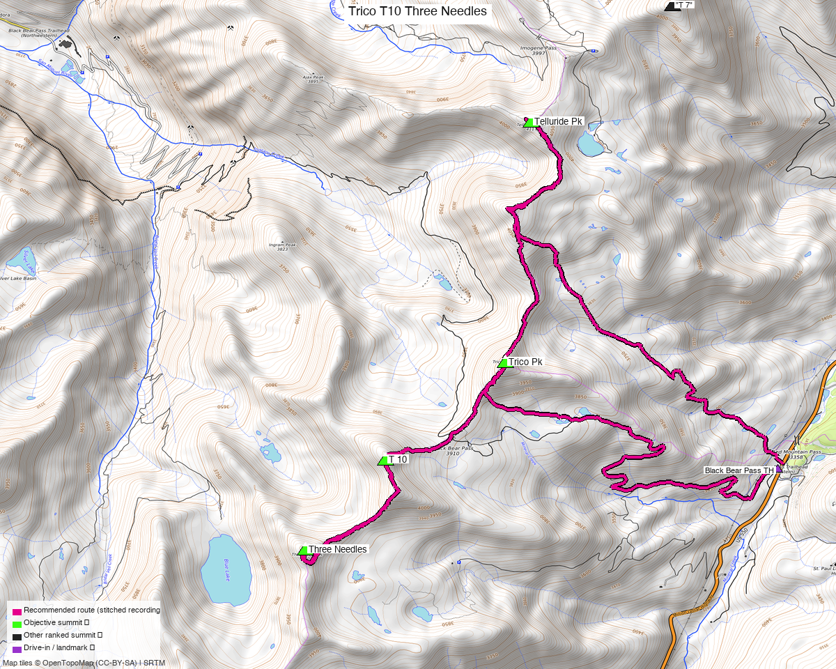
Note: the recommended route was distilled from 21 recorded GPS tracks of real trips (14ers.com · ListsofJohn · peakbagger · Kyle's recordings) — all layered on the interactive CalTopo research map.
Four peaks, not three
This started as a three-peak group — Trico, "T 10", Three Needles. Telluride Peak came along
for free. The cleanest recorded line through the other three, trk_14ers_1, is a 9.8 mi round
trip that passes 22 ft from Telluride Peak's summit. It is not a detour and not a variation;
that party walked over it on the way round. Since it is ranked, 13,514', and unclimbed, leaving
it out would have meant recording a deliberate decision to cross a summit and decline to count
it. So it is the fourth objective.
| Peak | Elev | LoJ class |
|---|---|---|
| Telluride Peak | 13,514' | 2 |
| Three Needles | 13,494' | 3 |
| "T 10" | 13,484' | 2 |
| Trico Peak | 13,329' | 2 |
Ouray / San Juan counties — Uncompahgre National Forest, the ridge west of Red Mountain Pass.
The trailhead decision — and what a 4WD saves
The recorded tracks split into two groups, and the difference is entirely about how far you drive.
Three parties drove up Black Bear Pass Road and started at 11,743–11,848'. trk_14ers_1,
the tidy 9.8 mi four-peak loop, is one of them. That road is OSM surface=unpaved,
smoothness=horrible, tracktype=grade2 — Black Bear is a famously committing shelf road.
The route here starts lower, at the mapped Black Bear Pass Trailhead on US 550 at
11,071', which has a highway=trailhead node and mapped parking, and where two other recorded
parties began. That costs about 2.5 mi and 700 ft over the high starts — the difference
between the 9.8 mi recording and the 12.3 mi here.
If you have the vehicle and the nerve for Black Bear Pass Road, drive to ~11,750' and the day becomes roughly the recorded 9.8 mi. The published figure assumes you did not, because a report that quietly bakes in a horrible-grade 4WD ascent is a report that lies to anyone without one.
The recommended route — 12.3 mi / 5,572 ft
A loop from the trailhead over all four, stitched from the best recorded segment per leg:
| Leg | Distance | Source |
|---|---|---|
| TH → Telluride Peak | 3.68 mi | trk_14ers_3 |
| Telluride → "T 10" | 2.62 mi | trk_14ers_1 |
| "T 10" → Three Needles | 0.78 mi | trk_pb_2 |
| Three Needles → Trico | 2.07 mi | trk_14ers_1 |
| Trico → TH | 3.12 mi | trk_pb_1 |
Three Needles is the Class 3 summit and the crux of the day; the other three are Class 2.
One leg comes from a May recording
The trailhead-to-Telluride leg is drawn from trk_14ers_3, dated May 2017 — the only
recording in the pool that links this trailhead to Telluride Peak at all. Every other leg is
from a July/August track. The route composer scores distance, gain and on-trail fraction but
has no notion of season, so it cannot prefer a summer line on its own (a known, open
tooling gap). In May that corridor would have held snow; treat that leg's exact line as the
weakest beta in the route and expect the summer path to differ in detail.
Getting there
| Drive from Boulder | ~8h 10m via Google Maps — 366 mi |
| Trailhead | Black Bear Pass TH, 37.89662, −107.71364, 11,071' — mapped highway=trailhead with parking, off US 550 just north of Red Mountain Pass. Any vehicle. |
| Going higher | Black Bear Pass Road — smoothness=horrible, tracktype=grade2. Saves ~2.5 mi and ~700 ft. Serious 4WD only. |
| Land | Uncompahgre NF. The access sweep found three access=private parcels plus the Telluride, Silverton Mountain and Ironton Park ski areas in the wider box; none touch the route. |
Gear & season
- Best window: July through September.
- Terrain: Class 3 on Three Needles, Class 2 elsewhere; loose San Juan rock throughout.
- Helmet: yes, for Three Needles.
- Storms: the whole loop is above treeline — early start.
Other considerations
The south pair — Bridal Peak + PT 13,145 — sits on the same ridge system, and Three Needles is only ~0.95 mi from Bridal Peak. They are split into their own report because the sensible access differs, but if you are making the 8-hour drive, the two reports together are a strong two-day pairing out of Ouray or Telluride.
Trip reports & GPX (all three sources)
All three sources swept across all four objective peaks and deduped, plus the mapped OSM trail network — all layered on the research map.
- 14ers.com: peaks 10447, 10387, 10384, 10375 — 4 GPX-library tracks (plus 2 duplicates).
- listsofjohn.com: peaks 469, 334, 331, 311 — 7 tracks from 28 trip reports (plus 5 duplicates). LoJ cross-verified the peakbagger ids: 15985 / 64569 / 15588 / 14672.
- peakbagger.com: peaks 15985, 64569, 15588, 14672 — 6 ascent tracks with GPS (plus 4 duplicates).
Sources checked: 14ers.com ✓ · listsofjohn.com ✓ · peakbagger.com ✓