Other climbers: Emily Sharpe — not yet · Shawn D Keil — not yet
Henry Mountain — 13,272' (Sawatch / Gold Basin)
At a glance — recommended day
9.3 mi · 3,666 ft gain · Class 2 · 1 peak · ~5 h drive
NOAA weather link: Henry Mountain Weather
Drive from Boulder: ~5h via Google Maps
CalTopo research map: https://caltopo.com/m/8C0G05A
Researched: 2026-07-22
Status in Peak Checklist: unclimbed. A ranked (CO #424), Class 2 summit at the head of the Gold Creek drainage NE of Gunnison. A moderate day via Gunsight Pass — no technical terrain, just distance. Natural pair with nearby Fairview Peak.
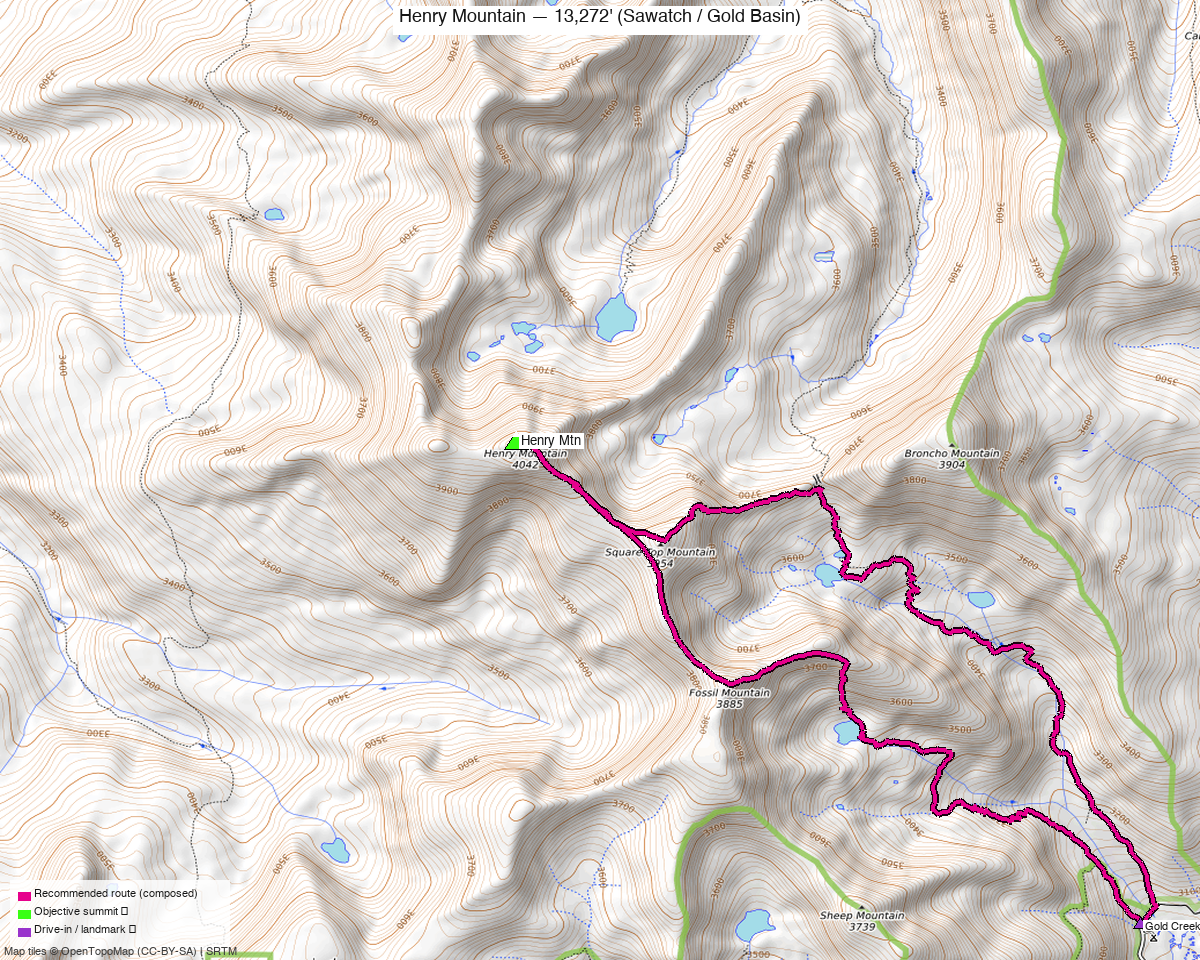
Note: the recommended route was distilled from 7 recorded GPS tracks of real trips (14ers.com · ListsofJohn · peakbagger) — all layered on the interactive CalTopo research map.
The peak
A Class 2 tundra-and-talus day from the Gold Creek trailhead, climbing over Gunsight Pass into the upper basin below Henry — ~9.3 mi / ~3,670 ft round trip. The distance and altitude are the work; there's no scrambling.
| Henry Mtn | |
|---|---|
| Elevation | 13,272' |
| Lat / Lon | 38.6856, −106.6211 |
| Route | Gold Creek → Gunsight Pass → E slopes |
| Class | 2 |
| CO rank | #424 |
| listsofjohn.com | 541 |
| peakbagger.com | 5758 |
Recommended route — Gold Creek + Gunsight Pass ⭐
The composed line follows a recorded track from the Gold Creek trailhead over Gunsight Pass to the summit — ~9.3 mi · ~3,670 ft, Class 2.
Route sequence
- From the Gold Creek / Gold Basin SE TH (~10,060'), follow the trail up the Gold Creek drainage toward Gunsight Pass (~12,100').
- From the pass, contour/climb west into Henry's upper basin and up grass and talus slopes to the summit (13,272') — Class 2, straightforward.
- Reverse the route.
Getting there — Gold Creek / Gold Basin TH
| Drive from Boulder | ~5h via Google Maps — via US-285 / US-50 to Gunnison, then up the Gold Creek Rd (FR 771) system to the SE trailhead. |
| Trailhead | Gold Creek / Gold Basin SE TH, ~10,060'. The access road is unpaved; high-clearance helps but the trailhead is more accessible than Fairview's upper-basin start. |
| Land | GMUG NF — no permits/fees; not designated wilderness. |
Gear & season
- Best window: July–September — Gunsight Pass and the upper basin hold snow into early summer.
- Terrain: Class 2 trail, tundra, and talus — no scrambling; the day is about distance and altitude.
- Storms: a long day with sustained time above treeline over Gunsight Pass — start early, turn around for weather.
- Cell: unreliable in the Gold Creek drainage; carry an InReach.
Other considerations
- Longer northern approaches exist (~17 mi from the Henry Lake / north side) — the Gold Creek / Gunsight Pass line is much shorter and the standard way.
- Pair with Fairview Peak: Fairview is ~4.6 mi east in the same Gold Basin / Gold Creek system — an easy two-summit weekend, though each has its own trailhead and this report keeps them separate.
Trip reports & GPX (all three sources swept)
Sources confirmed logged in: 14ers.com ("Basin"), listsofjohn.com ("letsgocu"), peakbagger.com ("Kyle Knutson"). 6 tracks — 5 from listsofjohn TRs, 1 from a peakbagger ascent (14ers-library tracks deduped against these). All layered on the research map; recommended route magenta.
listsofjohn.com — Henry (peak 541) trip reports: the Gold Creek / Gunsight Pass line (~9–10 mi) plus longer ~17-mi northern approaches.
peakbagger.com — 1 ascent track via Gold Creek (the recommended line).
14ers.com — library tracks (deduped against the LoJ/peakbagger set).
Sources checked: 14ers.com · listsofjohn.com · peakbagger.com · climb13ers.com