"V 3" — the last one in the Ice Lake / Ophir basin (Class 3, best on snow)
Other climbers: Emily Sharpe — not yet · Shawn D Keil — not yet
At a glance — recommended day
6.7 mi · 3,472 ft gain · Class 3 · 1 peak · ~8.77 h drive
NOAA weather link: Ophir / V 3 Weather
CalTopo research map: https://caltopo.com/m/Q7PSNV7
Researched: 2026-08-04
Status in Peak Checklist: unclimbed — and it is the only thing left here.
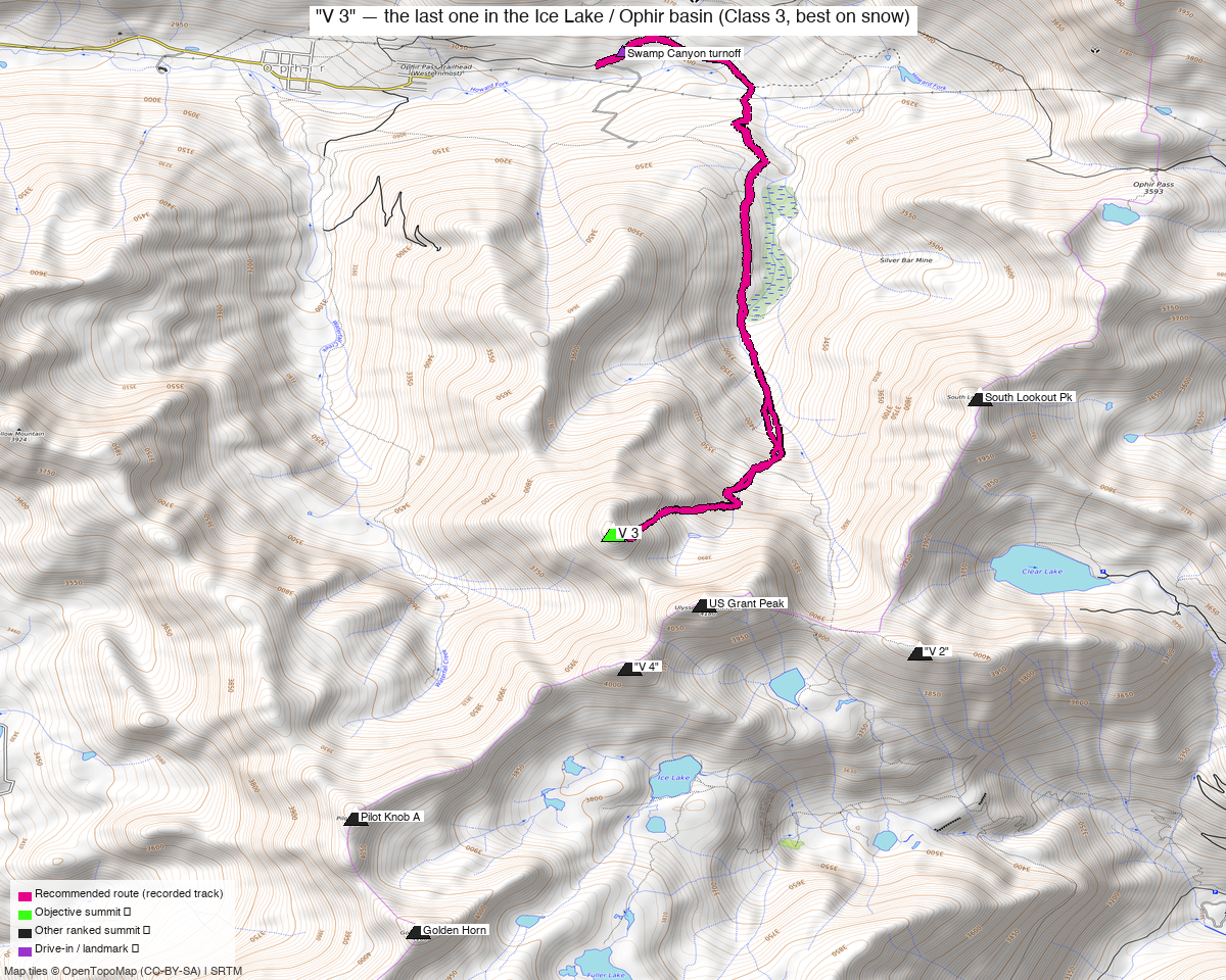
Note: the recommended route was distilled from 3 recorded GPS tracks of real trips (14ers.com · ListsofJohn) — all layered on the interactive CalTopo research map.
Go on snow. Dry, this gully is the crux; frozen, it is a moderate climb
Both parties who have written this peak up reach the same conclusion independently, and the reason is specific: the problem is not loose talus, it is hard-packed dirt that will not take an edge.
"The next 300-500 feet to the gully really sucked. Compact, dried, San Juan mud rock made things hard. The climbing, although not very steep, was very challenging. I think this section would be much easier after a rain storm as it would soften the mud, actually making suitable foot holds." — Furthermore, 2011
"Talk about sketchy! I agree with Furthermore that this would be best done after a rain or snowmelt — the hard-packed dirt and scree is what made the gully so treacherous." — whileyh, 2020
Dry, the gully holds a few very short Class 3 moves to bypass a short cliff, on ground that does not accept a boot. That is what sets the Class 3 grade, and it is why the recommended route here is the spring snow ascent rather than the summer walk-up.
Helmet either way — the gully is a fall line.
The peak
| Peak | Elev | Class | CO rank | Rise |
|---|---|---|---|---|
| "V 3" | 13,545' (LiDAR) | 3 | 224 | 400' |
San Miguel County, Ophir quad, Uncompahgre National Forest — public land the whole way, which after the Culebra Range reports is worth saying out loud.
Line parent is Ulysses S. Grant Peak, just 0.42 mi away.
This is the last unclimbed ranked peak in the basin for you. US Grant, "V 2", "V 4", "V 5", South Lookout, Pilot Knob A, Golden Horn, Vermilion, Beattie and Lookout are all done. That is also why this is a single-peak report rather than a combination — everything V 3 naturally links to, you have already climbed.
The recommended route — 6.7 mi / 3,472 ft, out and back, on spring snow
Swamp Canyon turnoff → old Swamp Canyon road → upper basin → 12,348' saddle → west slopes → summit gully → "V 3".
This follows trk_14ers_1, a May ascent of exactly that line. It is the same ground the
summer parties walk — what changes is the surface, and the surface is the whole story on this
peak:
"This route would make an excellent spring snow climb since the approach would be short from Ophir and the angle of the gully moderate. It also tops you out right there by the summit." — whileyh
Three things that recommendation is buying you: the gully's dried mud is replaced by something that takes a boot or a crampon, the moderate angle means it is a climb rather than a scramble, and it tops out at the summit instead of on the ridge short of it.
The measured line agrees with the summer beta on effort — Furthermore called the day "~5.8 Miles, ~3,400 Gain" in 2011, and the DEM profile here gives 3,472 ft. You are not taking on extra ground by going in spring; you are taking on the same ground in better condition.
The one navigational catch, from the party who got it wrong:
"The road was easy to follow but I completely missed the trail turn off to the upper basin just north of 'V 3.' There was a large cairn marking the junction (found on the way down) which I somehow missed."
Watch for that cairn. Above it the trail is good — "delightfully, the trail was excellent as it took me into the upper basin" at about 11,500 ft — and it runs out where the grass does. From there it is slopes on the south side of the basin to the 12,348' saddle, then north up onto the mellow west slopes and into the gully.
On snow that junction is a navigation problem, not a spotting problem — the cairn and the trail will both be buried. Carry the GPX and follow it up the drainage; the line is the same either way, and under snow the basin travel gets easier rather than harder.
If you go in summer instead
The July line is on the research map (trk_loj_14562, 6.6 mi / 3,423 ft, about 57% on mapped
trail) and it is a perfectly reasonable day — it is simply the worse version of it. Expect the
last 300–500 ft below the gully to be the hardest part of the outing, and expect it to feel out
of proportion to the grade.
If you do go dry, go after rain. That is the one conditions call both parties make, and they agree on it: wet mud holds a boot, dry mud does not.
Getting there — Swamp Canyon turnoff
| Drive from Boulder | ~8h 50m via Google Maps — to 37.85780, −107.81234, 10,091'. |
| The road | East out of Ophir on the Ophir Pass Road. Furthermore rated the drive to the turnoff 2WD with high clearance recommended; OSM tags the way 4wd_only + smoothness=very_bad, but that tag covers the whole road including the pass itself far above. Treat high clearance as the requirement and expect the surface to get worse if you continue up. |
| If you would rather not drive it | The mapped Ophir Pass Trailhead (Westernmost) sits 0.63 mi west at the edge of Ophir town. Starting there adds about 1.3 mi round trip on road. |
| Parking | A turnoff pullout, not a developed trailhead. No facilities. |
Gear & season
Target May. The recorded snow ascent is 2022-05-15; the recorded dry ascents are July and August. That May track also settles the access question — the Swamp Canyon turnoff was drivable then, which is the part of a spring plan most likely to fail. Ophir Pass itself opens much later, but you are nowhere near the pass.
- Axe and crampons. whileyh calls the gully angle "moderate" under snow — moderate is still a snow climb, and it runs straight to the summit with no bench to stop on.
- Helmet. In spring for what comes down the gully; in summer for what you knock down yourself.
- Start early and get off it. A south- and west-facing gully at 13,000 ft in May is a refreeze-dependent climb — it is good at dawn and rotten by midday.
- Check the avalanche forecast (CAIC, Northern San Juan). This is a confined gully below a steep face, which is exactly the terrain that keeps a load.
- Poles for the road and basin approach, which is snow-covered but low-angle.
- No water on the upper slopes; carry the day's supply from low down.
Other considerations
Nothing here pairs with it. Normally an 8h 50m drive would argue for stacking peaks, but you have already climbed every ranked summit within 3.5 miles. V 3 is genuinely a one-peak errand.
The nearest unclimbed thing is PT 13,145, 3.8 mi away — and 72 road miles. They sit on opposite sides of the divide: V 3 off Ophir Pass Road, PT 13,145 off the Columbine Lake Trail near CR 820. Straight-line proximity is a trap here. They are worth planning into the same San Juan trip, on different days, but not the same drive.
Trip reports & GPX (all three sources)
All three sources swept for this peak and deduped, plus the mapped OSM trail network — all layered on the research map.
- 14ers.com: peak 10370 — 2 GPX-library tracks: the 6.7 mi May snow line this route follows, and a 14.5 mi US Grant + V-peaks day. No formal route description.
- listsofjohn.com: peak 295 — 1 track
(
trk_loj_14562, the July day described above as the summer alternative) plus 1 duplicate of another source. Three trip reports, 67 recorded ascents. LoJ cross-verified the peakbagger id as 14661, matching peak_db. - peakbagger.com: peak 14661 — the ascent track found is a duplicate of another source.
Sources checked: 14ers.com ✓ · listsofjohn.com ✓ · peakbagger.com ✓