Belleview Mountain — a Maroon Bells 13er without the Maroon Bells (Class 2+)
Other climbers: Emily Sharpe — not yet · Shawn D Keil — ✓ climbed
At a glance — recommended day
8.6 mi · 3,068 ft gain · Class 2+ · 1 peak · ~6.77 h drive
NOAA weather link: Belleview Mountain Weather
CalTopo research map: https://caltopo.com/m/B4MSNL0
Researched: 2026-08-02
Status in Peak Checklist: unclimbed.
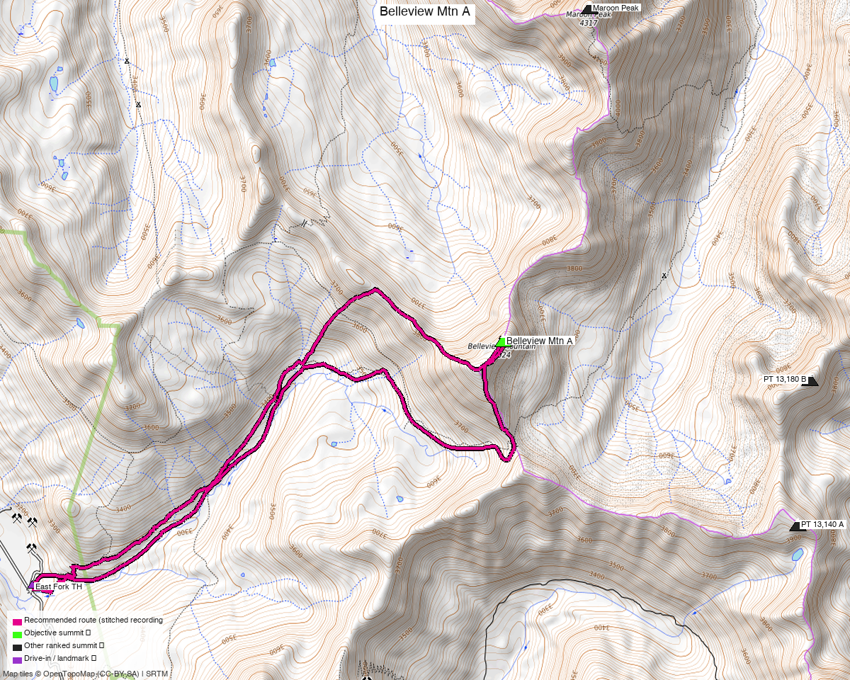
Note: the recommended route was distilled from 8 recorded GPS tracks of real trips (14ers.com · ListsofJohn · peakbagger) — all layered on the interactive CalTopo research map.
The peak
Belleview Mountain, 13,248' (LiDAR) — Colorado rank 441, and the 388th-highest of the state's 582 ranked 13ers. It sits on the Gunnison / Pitkin county line in the Maroon Bells–Snowmass Wilderness, White River National Forest, on the Maroon Bells quad.
Its line parent is Maroon Peak, 1.89 miles away, and that proximity is the whole point of this peak: Belleview looks straight across Fravert Basin at the Bells, Pyramid and the Thunder / Lightning Pyramid ridge, from a summit that asks for none of their commitment. It carries 705 ft of rise.
The interesting thing about Belleview is how few people bother. One trip-report author counted 110 recorded summits and concluded it is "the perfect peak to begin your Elk Range mountains." The Elks' reputation for rotten rock is earned, but it is earned mostly on the peaks around this one, not on this one.
The recommended route — 8.6 mi / 3,068 ft, a loop
From the East Fork Trailhead, composed per leg from two different summer recordings:
| Leg | Distance | Gain | On trail | Source |
|---|---|---|---|---|
| TH → Belleview (grassy rib) | 4.12 mi | 3,034 ft | 50% | trk_14ers_5 |
| Belleview → TH | 4.47 mi | 119 ft | 20% | trk_loj_901 |
This is a loop, not an out-and-back — the two legs share only 26% of their ground, and the descent gives back 119 ft over four and a half miles rather than reversing the climb. Start and finish are 95 ft apart.
The ascent deliberately skips West Maroon Pass. The obvious-looking line is to follow the West Maroon Trail all the way to the pass and turn up the ridge, and two independent parties report that it is the worse choice. bergsteigen went up to the pass, spent an hour looking at the scree, went home, and came back for the ridge instead:
"I spent an hour a little above the chaos of the pass, staring at this ridge… It just didn't look like fun." — 14ers TR 20818
The composed line matches what both of them settled on: follow the West Maroon Trail for about 2.4 miles, then leave it for the grassy rib that gains the northwest ridge directly. Steep grass with a few willows instead of loose scree, and a faint use trail once you are on it.
From the ridge it is a walk over the false summit (Pt 13,180-ish) — Class 2 the whole way — and then the ridge turns northeast for the summit block.
The summit block is the crux, and you get to choose your grade
Everything below the block is Class 2. The block itself is what the three trip reports disagree about, mildly:
- Around it (recommended, Class 2+). Stay right / east of the block and there are several ways up. whileyh: "intimidating but has numerous options that can be kept at C2+." JQDivide went around the NE side and found "maybe a C3 move, but we never put away our trekking poles."
- Straight up it (Class 3). bergsteigen took the first gully to a mini saddle and then "a classic Bells class 3 blocky route to the summit" — good rock, more fun, and entirely optional. He explicitly names the easier way around the horn to the east.
The headline 2+ is the harder of the two grades you can't avoid, not the hardest move available. Take the block direct if you want the scrambling; nothing about the route requires it.
The pool of recordings runs from 9.7 to 59.0 miles. The long end is not a longer way up this peak — it is the Mega-Maroonal Traverse, parties linking Belleview into Maroon, North Maroon, Sleeping Sexton and PT 13,048 over multiple days.
Getting there — East Fork Trailhead
| Drive from Boulder | ~6h 50m via Google Maps — 263 miles. |
| Trailhead | East Fork TH, 39.02488, −107.05073, 10,412' — also called the West Maroon TH (CB side). From Crested Butte take Gothic Road / CR 317 north over Schofield Pass; the trailhead is shortly past the pass. Bathrooms and parking for roughly 20 vehicles. |
| Road | Rough 2WD. The beta splits: whileyh says "2wd and a sedan can make it"; WildWanderer says 4WD but "a high clearance 2WD vehicle with a competent driver can make it." OSM tags the Schofield Pass Road approach surface=unpaved, smoothness=good, tracktype=grade2. Plan on high-clearance and it is a non-event. |
| Land | Maroon Bells–Snowmass Wilderness, White River NF. The OSM access sweep found no restricted or private areas anywhere near the route. |
Do not keep driving north past the trailhead
The trailhead sits at the top of the good road. North of it, the same route becomes
Crystal River Road heading for Devil's Punchbowl and Crystal — OSM tags that section
smoothness=very_bad, tracktype=grade4, degrading to smoothness=horrible a mile on. It is
one of the more notorious 4WD roads in Colorado and it is not on the way to anything you
need. Park at the trailhead and walk.
A popular trailhead on a summer weekend also means a full lot — this is the Four Pass Loop's West Maroon access, and JQDivide found it "full of vehicles for Four Pass Loop hikers" at 8am.
Gear & season
- Best window: July through early October. All eight recordings in the pool are summer or early fall, and two of the best trip reports are October — the Elks hold snow late and this approach is a south-facing basin, so autumn is genuinely good here.
- Terrain: Class 2 to the base of the summit block, Class 2+ on the block. Loose in places but far better than the West Maroon Pass alternative.
- Helmet: yes for the summit block, where several parties may be picking lines above each other. JQDivide's note — "give each other space, especially if you didn't bring a helmet" — is the practical version.
- Navigation: the point to get right is where you leave the West Maroon Trail for the grassy rib, roughly 2.4 miles in. Cairns exist higher on the ridge but not at the turn-off.
Other considerations
The all-Class-2 alternative, if you want the grade lower. WildWanderer's line goes further up the trail to Frigid Air Pass, then takes the long ridge southeast over Pt 13,210 to the summit — "it's all class 2, with game trails to follow." It costs 12.15 mi and 3,516 ft (their measurement) instead of 8.6 and 3,068, and it removes the 2+ block moves. That is a real option, not a consolation prize: 3.5 extra miles to drop a half-grade.
The lower-48 alternative that isn't. The West Maroon Pass approach is shorter-looking on a map and is the one most people picture. Both parties who tried it recommend against it. It is in the pool, and it is why some recorded tracks are steeper and slower than the mileage suggests.
Cheap add-on: Pk 12,489. whileyh picked it up on the descent — "an easy add-on… and worth the extra time" — descending its SE ridge to unmarked trails that rejoin the last half mile of the West Maroon Trail. Unranked, so it counts for nothing, but it turns the descent into new ground.
A Crested Butte weekend. Treasure + Treasury start from Paradise Divide, 4 miles down the same Gothic Road — a 10.1 mi Class 2 loop. Mount Owen is off Kebler Pass on the other side of town, 5.7 mi and Class 3. Any two of the three make a weekend from one Crested Butte basecamp without a second long drive.
The neighbors are a different proposition. Precarious Peak, "Golden Tops" and "Cassi Peak" sit 2.7–3.2 miles away and one party (LoJ TR 26959) linked them with Belleview, 13,223 and 13,144 in a single day from Rustlers Gulch. That is a much bigger and harder outing from a different trailhead — worth its own report rather than an add-on to this one.
Trip reports & GPX (all three sources)
All three sources swept for this peak and deduped, plus the mapped OSM trail network — all layered on the research map.
- 14ers.com: peak 10120 — 5 GPX-library tracks from 13 trip reports. Note 14ers.com has no route description for Belleview; everything above comes from trip reports.
- listsofjohn.com: peak 558 — 2 tracks from 4 trip reports (plus 1 duplicate). LoJ cross-verified the peakbagger id: 16133.
- peakbagger.com: peak 16133 — 1 ascent track with GPS (plus 1 duplicate).
Sources checked: 14ers.com ✓ · listsofjohn.com ✓ · peakbagger.com ✓