Rito Alto Group — 3-Day Trip (4 peaks, Sangre de Cristo, Class 2)
At a glance — 3-day trip
4 peaks · ~4.5 h drive
- Day 1 (Drive + pack in): 5.36 mi · 1,339 ft gain · Class 1
- Day 2 (PT 13,054 (Pyramid Mtn)): 11.8 mi · 4,641 ft gain · Class 2 · 1 peak
- Day 3 (North 3 + pack out): 9.15 mi · 4,016 ft gain · Class 2 · 3 peaks
NOAA weather link: Rito Alto basin Weather
Drive from Boulder: ~4h 30m via Google Maps
CalTopo research map: https://caltopo.com/m/F73MQB1
Researched: 2026-07-22
Status in Peak Checklist: all 4 unclimbed. Four ranked west-Sangre 13ers arrayed above Rito Alto Lake — three on the north crest (PT 13,062 A "Mas Alto", PT 13,060 A "Alto", PT 13,031 "Menos Alto"), one to the south (PT 13,054 "Pyramid Mtn"). All neighbors of the crest — Rito Alto Pk, Hermit Pk A, Eureka Mtn A — already climbed.
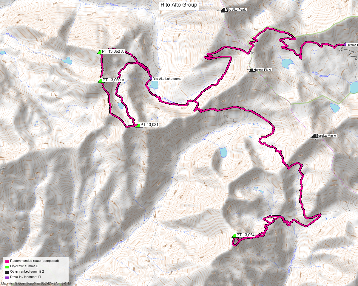
Note: the recommended route was distilled from 24 recorded GPS tracks of real trips (14ers.com · ListsofJohn · peakbagger) — all layered on the interactive CalTopo research map.
Other climbers: Emily Sharpe — not yet · Shawn D Keil — 3 of 4 (Mas Alto Peak, Alto Peak, Menos Alto Peak)
Peaks covered
A backpack from a Rito Alto Lake basecamp, accessed via the Hermit Pass Rd TH (4WD, ~11,690') on the east side of the range — much shorter than the ~7.5 mi west approach. Hardest move Class 2 throughout (four standard-route PTs; no exposed connecting ridge on this line).
| Peak | Day | Elev | Class | Prom | CO rank |
|---|---|---|---|---|---|
| PT 13,054 "Pyramid Mtn" | 2 | 13,054' | 2 | 610' | #605 |
| PT 13,062 A "Mas Alto" | 3 | 13,065' | 2 | 862' | #594 |
| PT 13,060 A "Alto" | 3 | 13,059' | 2 | 362' | #602 |
| PT 13,031 "Menos Alto" | 3 | 13,031' | 2 | 322' | #617 |
All four sit inside the Sangre de Cristo Wilderness (Rio Grande NF). Pyramid Mtn is the south peak — parent Eureka Mtn A, reached from Rito Alto Lake via a mapped trail south past San Isabel Lake. The north 3 form a chained crest ridge directly above the lake basin (PT 13,062 A is line parent of PT 13,060 A and PT 13,031 both).
Getting there — Hermit Pass Rd TH (east side, 4WD)
Drive from Boulder: ~4h 30m via Google Maps — I-25 S to Colorado Springs, US-50 W to Cañon City, CO-69 S to Westcliffe, then the Hermit Pass Road (Custer County Rd 160 → FS 160) up out of the Wet Mountain Valley to the trailhead at ~11,690'.
| Trailhead | Hermit Pass Rd TH, 38.09612,-105.63400, ~11,690' (end of 4WD road) |
| Access | 4WD required — Hermit Pass Rd (FS 160) climbs from Westcliffe (~7,900') to ~11,690' on a rocky, high-clearance road. Multiple 14ers/LoJ TRs confirm 4WD-only above the lower switchbacks. |
| Wilderness | Sangre de Cristo Wilderness (Rio Grande NF, east side) — no permits/fees; standard wilderness rules (LNT, no mechanized travel). |
The days, in order
Day 1 — Drive from Boulder, pack in to Rito Alto Lake
~5.36 mi · ~1,339 ft on mapped OSM trails — first Hermit Lake Road (highway=track,
the 4WD dirt road extension from TH), then Rito Alto Trail over Hermit Pass (~13,000') and
down west into the Rito Alto basin. The trail passes right through camp at the lake's west
shore.
Camp: Rito Alto Lake (~11,880'). Documented backpack site — AllTrails "Rito Alto Lake via Rito Alto Trail" has 14 backpacker reviews; the campsite is a spur trail up an embankment on the left side of the trail in low conifers, before the NW stream crossing.
Day 2 — PT 13,054 "Pyramid Mtn" (Class 2)
~11.80 mi · ~4,641 ft — the longest day, front-loaded. From camp, back on the Rito Alto Trail briefly and then onto the North Fork Crestone Trail (which runs SE from just east of the lake past San Isabel Lake area down to Pyramid Mtn's east basin at ~12,000'). From the trail's south end, a short off-trail east-lobe climb (~0.7 mi) reaches the summit — this is the recorded standard route per trk_14ers_2. Return via the same line.
Class 2 tundra and talus; standard route per LoJ.
Day 3 — North 3 + pack out to trailhead
~3.79 mi climb + ~5.36 mi pack out = 9.15 mi · ~4,016 ft total.
Morning climb — camp-to-camp loop over the north 3, verbatim from trk_loj_14848 (a recorded east-side loop). From camp, the recorded trail ascends the west drainage NW to the crest, tags PT 13,062 A "Mas Alto" (13,065'), traverses S along the ridge past PT 13,060 A "Alto" (13,059'), continues to PT 13,031 "Menos Alto" (13,031'), then descends the east ridge back to camp. All three saddles and both spur ridges recorded Class 2.
Then pack out — reverse of Day 1 back to the TH on the mapped Rito Alto Trail and Hermit Lake Road (~5.36 mi · ~1,679 ft gain back over Hermit Pass, then descent). Drive home ~4.5 h.
Camps & water
- Basecamp — Rito Alto Lake (~11,900'): a documented and reasonably-used Sangre backpack site. AllTrails reports 14 backpacker reviews including "spent the night at the lake and the next day fishing — lovely." Water directly from the lake; treat.
- Nights required: 2 (arrive Day 1 evening, sleep at camp before Day 2 climb, sleep again before Day 3 pack-out).
- Alternate water on trail: Rito Alto Creek flows below the lake (west); Middle Taylor Creek watersheds drain both east (toward Hermit Pass Rd) and west. Reliable through the standard July–September window.
Gear & season
- Best window: July through September — Hermit Pass Rd melts out by mid-June; the basin holds snow into early July most years.
- Vehicle: 4WD required for Hermit Pass Rd. Without 4WD, the west-side approach from the San Luis Valley (Rito Alto Trailhead, 8,255') adds ~7.5 mi one-way to the lake and ~1,500 ft more gain — see Other considerations.
- Terrain: Class 2 on all objectives; no rope/helmet/axe/crampons in season. Peak days spend meaningful time above 13,000' — plan early starts, off high ground by early afternoon monsoon.
- Cell: unreliable throughout; carry an InReach for this backpack. Neighbor 14ers have no useful cell data.
Other considerations
Why the east (Hermit Pass Rd) approach vs. the west (San Luis Valley) approach? The recorded objective tracks all start from the west TH (8,255') and climb 15+ mi round-trip to reach any of the four peaks. From the east — a 4WD start at ~11,690' — the pack-in to Rito Alto Lake is only ~4.8 mi with ~1,600 ft gain, and once at camp both peak-days shrink substantially. If 4WD isn't available, the west approach becomes the default — expect each peak-day to become a long single-push round-trip (~13–17 mi with 5,000–6,000 ft gain); in that case a 2-day car-camp near the west TH doing the north 3 (one big day) and PT 13,054 (a separate long day) is the alternative structure, not a backpack.
Route note on the north 3 (Day 3): the approach and descent from camp to the crest are off-trail cross-country through the Rito Alto Lake basin — no recorded track covers those segments (all west-side TRs climb from the opposite drainage). The recommended-route line on the map draws these as densified straight-line spurs; on the ground a hiker picks the natural terrain up the drainage.
Ridge-neighbor beta (informational): Rito Alto Pk, Hermit Pk A, Eureka Mtn A are the three climbed neighbors on the same crest. climb13ers and 14ers TRs document the Hermit → Eureka → Rito Alto crest traverse as Class 2/2+ ("moderately rocky, fun rock and wildflowers, a documented 4–5 summit day") — so the connecting terrain is friendly if one wanted to combine an unclimbed objective with a re-visit of a neighbor.
Trip reports & GPX (all three sources)
Sources confirmed logged in: 14ers.com ("Basin"), listsofjohn.com ("letsgocu"), peakbagger.com ("Kyle Knutson"). Recorded tracks for all 4 objectives were swept across the 3 sources; neighbor-peak libraries (Hermit / Eureka / Rito Alto) were also swept for ridge-access beta and layered on the CalTopo map.
listsofjohn.com
| Date | Author | Peaks | TR |
|---|---|---|---|
| 2024-06-17 | josephnephi | PT 13,062 + 13,060 + 13,031 (north 3 crest chain) | various |
| 2024-05-05 | josephnephi | PT 13,054 (Pyramid Mtn) | various |
| 2021-04-10 | (neighbor) | Eureka → Hermit → Rito Alto (crest ridge traverse — key east-side approach beta) | — |
14ers.com (logged in, "Basin")
Peak pages exist for all four (10685/10686/10687/10689); no formal route descriptions (these are LoJ-native PTs). GPX-library tracks layered on the CalTopo map.
peakbagger.com (logged in, "Kyle Knutson")
Ascent GPX pulled for all four (verified pids 84754 / 84755 / 84756 / 84753). Neighbor peak ascents (Hermit 19704, Eureka 14673, Rito Alto 5898) also swept — see amber tracks on the research map for crest approaches.
Sources checked: 14ers.com ✓ (logged in, "Basin") · listsofjohn.com ✓ (logged in, "letsgocu") · peakbagger.com ✓ (logged in, "Kyle Knutson")