West Elk Peak — West Elk Wilderness highpoint from Rainbow Lake (Class 1+)
Other climbers: Emily Sharpe — not yet · Shawn D Keil — ✓ climbed
At a glance — recommended day
14.6 mi · 3,989 ft gain · Class 1 · 1 peak · ~6.56 h drive
NOAA weather link: West Elk Peak Weather
CalTopo research map: https://caltopo.com/m/C9U336L
Researched: 2026-07-29
Status in Peak Checklist: unclimbed. Do not let the CO rank of 610 fool you — this is a far more significant summit than its height rank suggests: the highpoint of the West Elk Wilderness, CO prominence rank 17 with 3,094' of rise, and 13.8 mi of isolation from its parent, Mount Owen. It stands alone — there is no ranked peak within 8 miles, so this is a true standalone trip with nothing to combine it with.
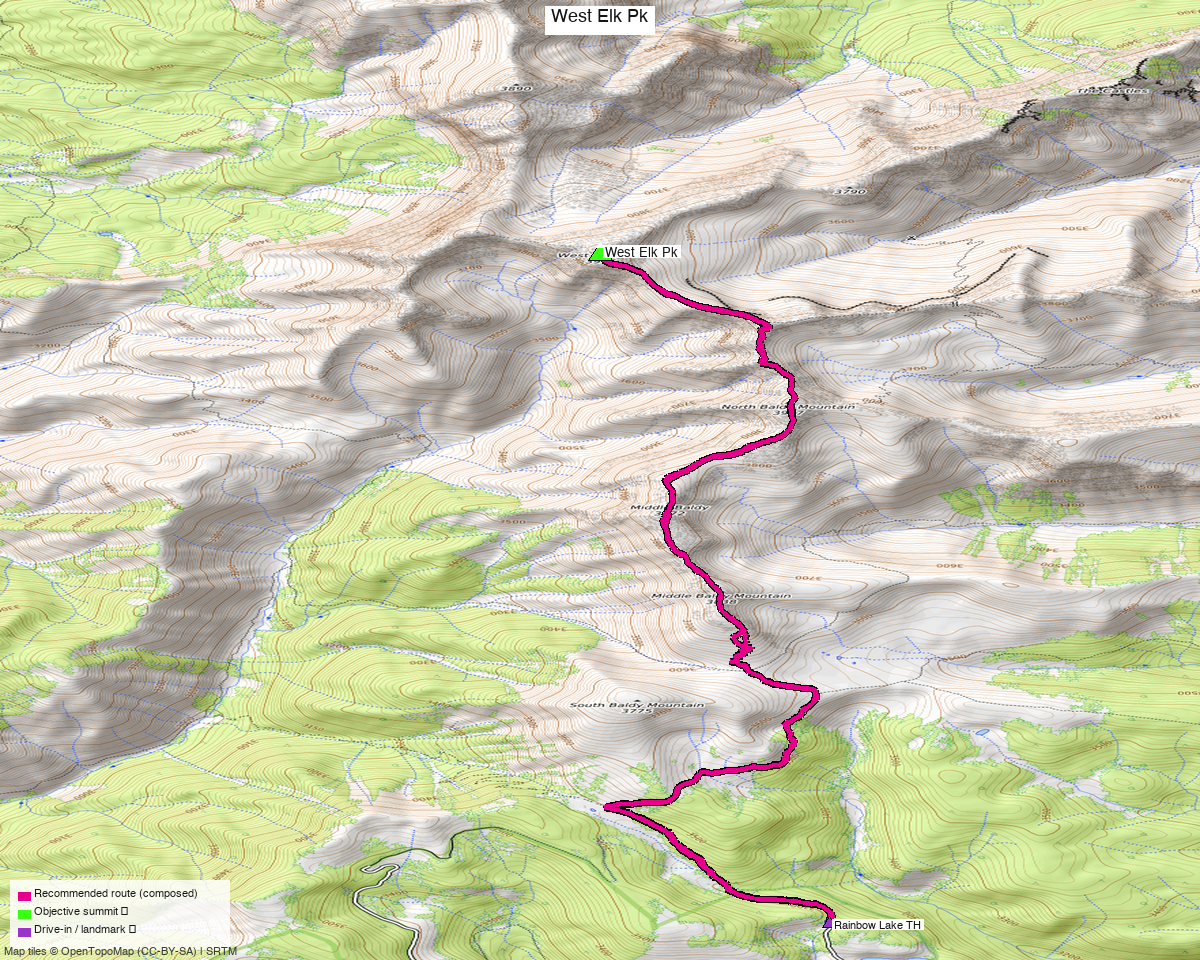
Note: the recommended route was distilled from 14 recorded GPS tracks of real trips (14ers.com · ListsofJohn · peakbagger) — all layered on the interactive CalTopo research map.
Peaks covered
One Class 1+ peak in the West Elk Mountains — a separate range from the Elks proper, southwest of Crested Butte and north of Gunnison.
| Peak | Elev | Class | CO rank | Prom | Isolation | Status |
|---|---|---|---|---|---|---|
| West Elk Peak | 13,040' (LiDAR; map 13,035') | 1+ | 610 | 3,094' rise (CO prom rank 17) | 13.8 mi | unclimbed |
Gunnison County, West Elk Peak quad — West Elk Wilderness, Gunnison NF. No permits or fees. The wilderness is one of Colorado's quietest; expect solitude and very little trail traffic.
Recommended route — Rainbow Lake trail ⭐
~14.6 mi · ~3,990 ft round trip, Class 1+, a loop from the Rainbow Lake TH (11,054').
Terrain-wise this is a walk-up — LoJ rates it 1+, and the whole challenge is distance, remoteness and navigation, not the ground underfoot. The line follows the Rainbow Lake trail system north into the wilderness and up onto West Elk's slopes to the 13,040' summit, returning the same way.
Nearly 15 miles for a Class 1 peak is the shape of this trip. It is a long day in a remote wilderness with little traffic, so carry navigation and self-rescue capability accordingly.
Route sequence
- From the Rainbow Lake TH (11,054'), follow the Rainbow Lake trail north into the West Elk Wilderness.
- Continue on trail through the basin toward West Elk's south side.
- Climb the walk-up slopes to the 13,040' summit — the wilderness highpoint.
- Return the same way to close the loop at the trailhead.
Getting there — Rainbow Lake TH (11,054')
| Drive from Boulder | ~6h 35m via Google Maps — the long way round to the Gunnison side |
| Trailhead | Rainbow Lake TH, 38.63961, −107.18503, 11,054' (OSM "Rainbow Lake Trailhead", a named parking node) |
| Road | Rainbow Lake Trailhead Rd is surface=dirt, smoothness=good — a genuinely reasonable approach road, unusual for a peak this remote. Good clearance is sensible but this is not a 4×4 grind. |
| Wilderness | West Elk Wilderness (Gunnison NF) — no permits/fees; standard LNT, no mechanized travel. |
Why not the Mill Creek side? Five recorded tracks start at Mill Creek / Guerrieri Rd instead
(DEM 9,055'), but that road is smoothness=very_bad, tracktype=grade5 — a 4×4 route — and
starting 2,000 ft lower makes for a bigger day. The two trailheads are ~2h 15m / 44.6 mi apart
by road (drive_matrix.py), so this is a real either/or decision made before you leave home, not
something to change your mind about on the day.
Gear & season
- Best window: July through September. ⚠️ Two of the swept tracks are winter ascents (Dec 2020, Jan 2016) — those are ski/snow lines and are not the basis of this route.
- Terrain: Class 1+ — trail and walk-up slopes. No rope, axe or crampons in season.
- Navigation: the real skill here. Remote wilderness, sparse traffic, and a long day — carry map and compass as well as GPS.
- Vehicle: good clearance advised; the road itself is
smoothness=gooddirt. - Storms: ~15 mi round trip means you will be out a long time — start very early and watch the afternoon build.
- Cell: assume dead throughout the West Elk Wilderness — carry an InReach.
Other considerations
Nothing to combine — genuinely standalone. There is no ranked peak within 8 miles of West Elk (isolation 13.8 mi to Mount Owen). Unlike the Elk-range reports, there is no pairing to offer and no trailhead-proximity question to answer: this is one long day for one summit, and the ~6½ h drive has to be justified on the peak's own merits.
Those merits are real, though. A wilderness highpoint with 3,094' of prominence — 17th in Colorado — is a much bigger objective than "CO rank 610" implies. If prominence or wilderness highpoints interest you at all, this outranks plenty of higher summits.
Trip reports & GPX (all three sources)
Sources confirmed logged in: 14ers.com ("Basin"), listsofjohn.com ("letsgocu"), peakbagger.com ("Kyle Knutson"). All three swept, plus the 12 mapped OSM trails in the West Elk basin — all layered on the research map.
- 14ers.com: peak page 10134 — 5 GPX-library tracks (two of them winter ascents). No formal route description.
- listsofjohn.com: peak 787 — Class 1+ rating; 4 trip reports (josephnephi 2024, Alyson Kirk 2016, jmbrooks8 2013, RyanKowalski 2010) and 3 downloadable tracks. 103 members have logged ascents.
- peakbagger.com: peak 5717 — 6 ascent tracks with GPS, the widest coverage of the three.
Sources checked: 14ers.com ✓ (logged in, "Basin") · listsofjohn.com ✓ (logged in, "letsgocu") · peakbagger.com ✓ (logged in, "Kyle Knutson")