Dolores Peak + Middle Peak (13,289' / 13,305') via Fish Creek — San Miguel Mountains, San Juan Range
Other climbers: Emily Sharpe — not yet · Shawn D Keil — ✓ all
At a glance — recommended day
8.1 mi · 3,974 ft gain · Class 2 · 2 peaks · ~11.81 h drive
NOAA weather link: Dolores Peak + Middle Peak (13,289' / 13,305') via Fish Creek — San Miguel Mountains, San Juan Range Weather
Drive from Boulder: ~11h 50m via Google Maps
CalTopo research map: https://caltopo.com/m/41S5TTJ
Researched: 2026-08-08
Status in Peak Checklist: climbed. Kyle walked both summits on 2026-06-20 — his own recording (8.5 mi round trip, Middle then Dolores) is on the research map in blue, and it matches the recorded consensus for this trailhead almost exactly. This supersedes an earlier version of this report that listed both peaks as unclimbed (0 ascents); the status has flipped. What the report is for now is the neighbourhood: Boskoff Pk, PT 13,507 and PT 13,540 B are all still open within 5.5 mi, and they sit on the other side of this cluster — so the value here is the access knowledge and the honest link-up arithmetic, not another trip up Fish Creek.
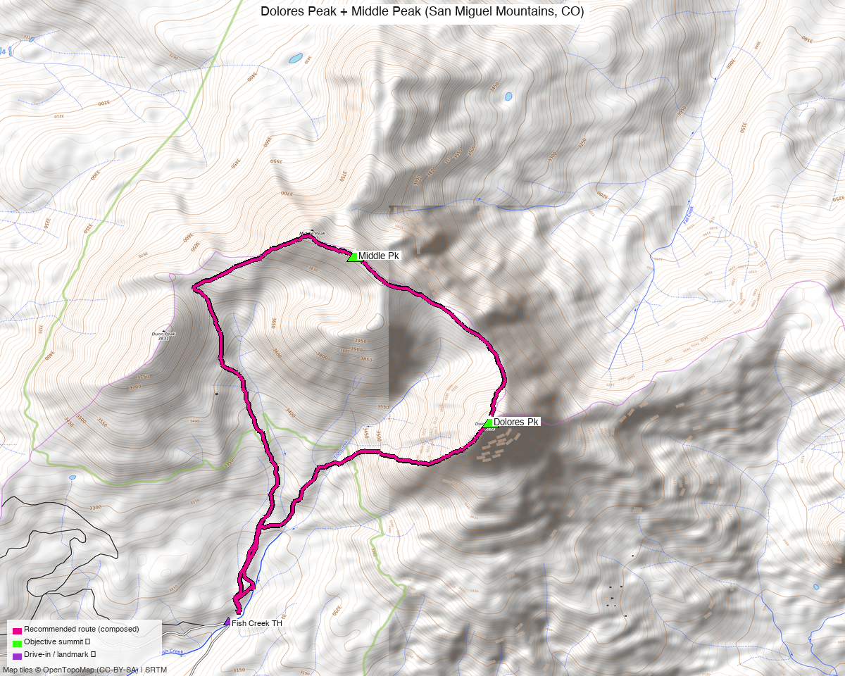
Note: the recommended route was distilled from 8 recorded GPS tracks of real trips (14ers.com · ListsofJohn · peakbagger) — all layered on the interactive CalTopo research map.
Peaks covered
Dolores and Middle are the western two of the San Miguel Mountains "trilogy" — the third member, Dunn Pk (12,612'), is unranked — sitting on the Dolores Peak quad in the San Juan National Forest, across the Lizard Head Wilderness from the Wilson group. climb13ers frames both peaks the same way: "one of a trilogy group whose nearest neighbors are the Wilson group located back to the northeast," closest town Telluride, graded dirt/gravel drive required. Middle is the higher and by far the more prominent of the pair (13,305' on 1,960' of prominence, against 13,289' on 730'), and the two are only 1.11 mi apart on one continuous ridge — which is why every single one of the eight recorded tracks swept for this report takes both in a day, and not one takes only one. The trailhead approach is on National Forest land outside the wilderness boundary, so there are no permits and no fees; standard forest rules apply, and there is dispersed car camping at the trailhead itself.
| Peak | Elev | Class | CO rank | Status |
|---|---|---|---|---|
| Middle Pk | 13,305' | 2 | 398 | climbed |
| Dolores Pk | 13,289' | 2 | 410 | climbed |
Recommended route — the recommended line ⭐
8.1 mi · ~3,974 ft, Class 2 — a true loop, not an out-and-back: up the west bank of Fish Creek to the Middle/Dunn saddle, over Middle, southeast along the crest to Dolores, then down off Dolores into the Fish Creek drainage and out. The line closes 22 ft from where it started. It is composed from two recordings, not one party's day: the climb to Middle follows a dense July track, and everything from Middle onward — the crest to Dolores and the whole descent — follows an August one.
On the class, plainly: this is the rare link-up where the connecting ridge does not raise the grade. Traverses normally run one to two classes harder than the summits they join, and this report would headline the harder number if that were true here. It isn't. climb13ers grades both peaks Class 2 by their standard lines — Dolores' North Ridge (exposure "Minimal", rubble/scree/talus, routefinding "Easy") and Middle's West/NW Ridge (exposure "Minimal", routefinding "Moderate") — and the connecting crest between the two summits is described inside that same Class 2 route: "proceed on to Dolores Peak by continuing generally south along the ridge crest," mostly easy going over broken rock rubble with one saddle en route. So the summit-to-summit terrain is walking on rubble, not scrambling, and Class 2 is the honest headline for the whole day.
The Class 3+ ground here is a variant you have to go looking for. Middle's west ridge taken direct — rather than gained from the saddle as the recommended line does — is a different proposition: Earthline (van Winegarden, 2015-10-01) describes it as "razor sharp, only one foot wide in places," serrated down the centre, with an upper section "very steep and rubbly" and one spot holding a fin with a roughly 20 ft drop that may want a Class 4 move to get around. The Telluride Mountain Club's Middle Peak loop describes Class 4 scrambling on the same feature. Take it if you want the scramble; skip it by descending Middle to the south side of the Middle/Dunn saddle on talus, which keeps the day at Class 2.
Two things the recordings agree on that the map won't tell you: Middle has a false summit at the 13,261' point marked on the survey map — the true summit is an easy stroll southeast along the ridge — and from the first saddle south of Middle it is easy to get steered out to Pt 13,246; Dolores is farther south and more isolated than it looks.
Route sequence
- Fish Creek TH, 10,195' — start on the west side of the creek. A trail climbs left onto an old logging road. This basin is laced with grown-over logging roads, each (in climb13ers' description) "maybe 20 to 50 feet higher in elevation than the last" — use them to gain ground up the drainage.
- West bank, above the gorge. Fish Creek narrows and "staying down by the creek is pointless." Stay well above it on the west bank and follow a minor ridge up through open forest onto a couple of benches. After roughly half a mile to a mile the roads run out; keep climbing on the ridge overlooking the creek.
- High bench to the Middle/Dunn saddle, ~12,300'. A game trail traverses the bench, staying just below the rubble under the cliffs on Dunn's east side, then drops into the centre of the drainage and crosses tundra to the saddle.
- Middle Pk, 13,305' via the west ridge. The first 400 ft is "rocky but straightforward"; the next 600 ft is considerably steeper and very rocky, and slow going on broken rock. From below it looks like it might cliff out — "nothing really hinders." It eases about 200 ft from the top. Cross the 13,261' false summit and continue southeast to the true summit.
- The crest to Dolores Pk, 13,289', 1.5 mi. Mostly easy rubble along the ridge. One saddle comes quickly — don't let it steer you out to Pt 13,246. From the last saddle there's a final 710 ft grunt over broken rock to the summit, with the Wilsons, El Diente and Navajo Lake filling the view east.
- Descend from Dolores back into the Fish Creek drainage and out to the trailhead. The published line follows one recorded party's actual descent the whole way down — a single unbroken leg from the summit to the car, trending west-southwest overall, since the trailhead lies that way and roughly 3,100 ft below. It does not go back over Middle, and that is the point of taking the peaks in this order. climb13ers describes their own descent in more detail if you want a picture of the ground: the central gully on Dolores' north side, small broken rock down to the first trees, cross to the north side of the drainage, then a fiddly crossing of the west fork of Fish Creek on rocks and logs and a steep scramble back up to the west bank to rejoin the morning route. Watch the navigation low down either way — the area has "quite a few faint logging roads … that lead in several directions," and the climb13ers party dropped to the creek too soon on their own descent.
Why Middle first — and why it's worth being deliberate about it. Six of the seven Fish Creek recordings walk Middle → Dolores, and both climb13ers pages describe the day in that direction. The reason is the descent: going this way you descend the loose ground off Dolores into the basin and ascend the steep broken 600 ft of Middle's west ridge. Reverse the loop and you get the worse half of both — climbing the loose gully, downclimbing the steep rubble. The only Dolores-first track from this trailhead is a May winter line. Take the peaks in the order above.
One line to avoid: Dolores' southwest slopes, dropping toward the Dolores County Road 52 side. A 14ers.com trip report (TR 19949, November 2019) went up that way, called it "incredibly dangerous" 40–45° loose scree, and the author disabled the GPX download as a warning — which is why no such track appears anywhere in the swept set. It is a different drainage from the descent above; don't confuse the two on the way down off Dolores.
Getting there — Fish Creek TH (FR 611 at Fish Creek, Dolores & Middle Peaks) (10,195')
| Drive from Boulder | ~11h 50m via Google Maps |
| Trailhead | Fish Creek TH (FR 611 at Fish Creek, Dolores & Middle Peaks), 37.82409, -108.11988, 10,195' |
| Real drive | ~7–7.5 h in practice. The estimate in the row above is too long — see the note below the table |
| Road | Passenger-car accessible, but a long way on dirt. CO 145 over Lizard Head Pass, 6.3 mi south to the Dunton turnoff (CR 38 / FR 535), then graded gravel past the Navajo Lake TH and Burro Bridge CG to the Dunton Guard Station junction (37.78018, −108.08915, 8,900'), then west on FR 611 for 5.2 mi to where the road bends sharply left and crosses Fish Creek. Park there, or turn right up the short road north along the creek to a small parking area. climb13ers: the Dunton Road "tends to be bumpy and washboarded, but passable to most passenger cars," and "most cross-over type vehicles and passenger cars with better ground clearance can make it to the trailhead." Don't try to drive higher — the spurs above the crossing are Middle Peak Road (OSM access=private, smoothness=very_bad) and Clear Fish Road (4wd_only=yes, tracktype=grade4), which is exactly why the parking is at the creek |
| Land | San Juan National Forest; the peaks border the Lizard Head Wilderness. No permits, no fees. Dispersed camping at the trailhead — a short road on the west side of the creek ends at a small parking area where a car camp works, and there's a vehicle pullout just before the crossing. Burro Bridge CG (north of Dunton) and West Dolores / Mavreeso CG (south) are the developed options |
About that drive time
The ~11h 50m figure in the table is what the routing estimator returns (409 mi), and it is over-costed: it prices the ~28 mi of graded gravel on the Dunton Road and FR 611 at rough-track speeds. The real drive from Boulder is about 7–7.5 hours. As a sanity check, the same estimator returns 8h 55m for the Rock of Ages TH four miles away, so the estimate is behaving consistently — it just doesn't reflect how fast a graded road actually goes. Plan on a long half-day of driving and a night at the trailhead, not a twelve-hour haul.
Gear & season
- Window: July through early October. The season split in the swept tracks is unusually clean — four summer recordings (July 2021, July 2023, August 2020, August 2025), one shoulder (October 2020), and three that classify as winter (November 2019 and two from May 2025). Two May tracks reading winter is not noise: this is a north-facing basin with the trailhead at 10,195', and climb13ers found the connecting ridge under snow cornices in late June — "At times, we found it covered with snow cornices, (our hike was in later June)."
- Road, not just snow, sets the season. The Dunton Road and FR 611 close once snow stays; in spring and late fall, check San Juan NF road conditions before committing to the drive.
- Footwear over anything technical. The whole day is rubble, scree and talus with two sustained steep-and-broken sections (Middle's upper west ridge, the last 710 ft up Dolores). Nothing on the recommended line calls for a rope or a helmet as a matter of course; a helmet is reasonable if there's a party above you on Middle's west ridge, which is loose.
- Early-season snow lingers in the upper basin and at the saddles into July on north and east aspects — an axe is worth carrying for a late-June or early-July attempt, not in August.
- Water on the way up from Fish Creek and its tributaries; treat it. Nothing above the basin, so tank up before the saddle.
- Storms and cold. Standard San Juan afternoon-convection discipline — be off the crest by early afternoon, since the ridge between the summits is the most exposed hour of the day. The September trip reports mention ground frost at the trailhead in the morning.
- Cell service: assume none. This is a remote corner of the forest well past Dunton, and the nearest town of any size is Telluride, an hour and a half away by road.
Other considerations
The alternative approach: 19.9 mi from Woods Lake
There is a second, completely different way at these two summits, and it is real rather than
theoretical: trk_loj_14537 is a genuine July 2023 recording that starts at the Woods Lake
TH (37.88673, −108.05474) on the north side and takes both peaks in a 19.9 mi round trip.
Woods Lake is also the only mapped highway=trailhead node anywhere in this report's evidence
— a real, signed, campground trailhead, in contrast with Fish Creek's park-at-the-creek-crossing
arrangement.
It is not the recommended line, for the obvious reason: 2.7× the mileage for the same two summits. But it is worth knowing about for two reasons. It's the better trailhead if you're already on the Telluride side and don't want the Dunton Road, and — more usefully — it's the approach that opens the Boskoff link-up below.
The link-up that's actually left: Boskoff Pk
Dolores and Middle are done. What's still open in this cluster is Boskoff Pk (13,134', 3.71 mi east), plus PT 13,507 (4.76 mi, Class 3) and PT 13,540 B (5.32 mi) — and all three are reached from the Rock of Ages / Woods Lake side, which is the subject of its own report. Two facts to carry into that decision:
- The single-push linkup goes. That same 19.9 mi Woods Lake recording is the evidence — a real party, in summer, on one day. But climb13ers' caution about doing this trilogy plus Boskoff in a push is that the effort is arduous and the ridge carries sustained exposure, so plan on Class 3+ on the Middle → Boskoff connector even though both endpoints are Class 2 summits.
- The two-trailhead version is cleaner and, given the drive, the one to plan: a Fish Creek day for Dolores + Middle, then roughly 1.5–2 hours of driving around to Woods Lake / Fall Creek Road for Boskoff. Since the first half of that is now climbed, what remains is simply the Boskoff day from the north side.
On combining trips generally: at seven-plus hours from Boulder, this corner of the San Juans is not a day trip and shouldn't be driven to twice. Anything still open here — Boskoff, PT 13,507, PT 13,540 B, and the Wilson-group leftovers — belongs in one multi-day trip out of the Rock of Ages / Woods Lake side, car-camping at the trailhead. Three to four summits across two days is well within range and beats two separate 800-mile round trips.
Dunn Pk, if you're back here anyway
Dunn Pk (12,612', unranked) sits directly on the approach at the Middle/Dunn saddle and costs roughly 0.2 mi and 600 ft. climb13ers pitches the trifecta outright — "if you like to 'clean out' an area, you may as well include Dunn Peak" — and the Earthline 2015 loop did exactly that. It counts for nothing on any ranked list, so it's a fun add-on and nothing more.
Not a combination: the Wilson group
Mt. Wilson, El Diente, Wilson Peak and Gladstone are 5.7–6.2 mi away as the crow flies but on the other side of the Lizard Head Wilderness, reached from Kilpacker or Rock of Ages. They are not linkable with a Fish Creek day. (All four are already climbed.)
Trip reports & GPX (all three sources)
Sources confirmed logged in: 14ers.com ("Basin"), listsofjohn.com ("letsgocu"), peakbagger.com ("Kyle Knutson"). All three swept fresh for this build, plus the mapped OSM trails in the bbox — all layered on the research map.
-
14ers.com: 2 track(s) harvested from the GPX libraries of Dolores Pk (10470) and Middle Pk (10460). One is the densest file in the whole set — 19,238 points over 6.4 mi (October 2020, shoulder season), and the shortest complete round trip anyone recorded from Fish Creek; it's the evidence that the day can be done in well under eight miles, though the composed line didn't end up using it. The other is a May 2025 line, rejected as winter. Trip-report beta from this source: TR 22348 (September 2023, Class 2, morning frost, calls out Middle's false summit) and TR 19949 (November 2019), whose author disabled his own GPX to warn people off Dolores' southwest slopes.
-
listsofjohn.com: 4 member trip-report tracks from peak 508 and peak 489 — the richest source here. Two are summer Fish Creek days (July 2021 and August 2020); the July 2021 track is the recommended line's ascent (5,474 points over 8.5 mi, ~8 ft spacing, closing 9 ft from its own start). A third is the 19.9 mi Woods Lake day discussed above, and the fourth is a November 2019 winter line, rejected.
-
peakbagger.com: 2 track(s) harvested (+5 duplicate(s) of another source), pids verified against the right peaks (Dolores 5818, Middle 14675). The August 2025 track carries the whole second half of the recommended line — the crest from Middle to Dolores and the entire descent — which is why the published route's descent is one recorded party's own way down rather than a reconstruction; the other is a May 2025 winter ascent that also starts 0.6 mi south of the trailhead, on Clear Fish Road — the only recording here that doesn't begin in the trailhead cluster, and the only one that climbs Dolores first.
On the two "School Bus" CalTopo lines. An earlier version of this report leaned on what it described as "a 3,312-pt track in Kyle's School Bus map (imported, source unknown)" as its evidence for the big linkup. Both of the CalTopo files in this collection are now identified, and neither is independent beta: each is a timestamp-stripped twin of a real recording already in the set. The 19.9 mi one is the ListsOfJohn Woods Lake track (same 3,312 points, same start); the 6.4 mi one is the 14ers.com October track (same 19,238 points, same start, same summit indices). They carry no per-point timestamps, so they cannot be dated, cannot be season-checked, and are excluded from route composition on principle — a planned or timestamp-stripped line cuts switchbacks that a recording follows. Nothing is lost by dropping them: the timestamped originals are on disk and are what the recommended route is built from. The "source unknown" question is closed.
How the recommended line was assembled. Eight recorded tracks survive deduplication, all eight summit both peaks. Three were rejected as winter (November 2019, and two from May 2025); two CalTopo files were rejected as drawn lines, as above. That leaves four summer tracks plus one shoulder-season track from the Fish Creek trailhead, and the 19.9 mi Woods Lake day. The published route stitches two of them rather than following any single party's day — and at 8.1 mi it lands near the top of the independently recorded range. The parties who walked this trailhead run 6.4–8.5 mi; Kyle's own June 2026 day measured 8.5 mi; climb13ers' arithmetic is the outlier low at 7.2–7.5 mi, and their figures are route-description estimates rather than measured tracks. So read 8.1 mi as a realistic full-day number, not an optimistic one — it is within half a mile of what Kyle actually walked here, and it is measured off recordings rather than estimated. Expect to add distance if you tack on Dunn or wander in the logging roads low down, but don't expect the day to come in short.
Sources checked: 14ers.com ✓ (logged in, "Basin") · listsofjohn.com ✓ (logged in, "letsgocu") · peakbagger.com ✓ (logged in, "Kyle Knutson")