Teocalli Mountain — a Class 2 walk-up above Brush Creek
Other climbers: Emily Sharpe — not yet · Shawn D Keil — ✓ climbed
At a glance — recommended day
6.1 mi · 3,064 ft gain · Class 2 · 1 peak · ~6.38 h drive
NOAA weather link: Teocalli Mountain Weather
CalTopo research map: https://caltopo.com/m/FBTS6VG
Researched: 2026-08-03
Status in Peak Checklist: unclimbed.
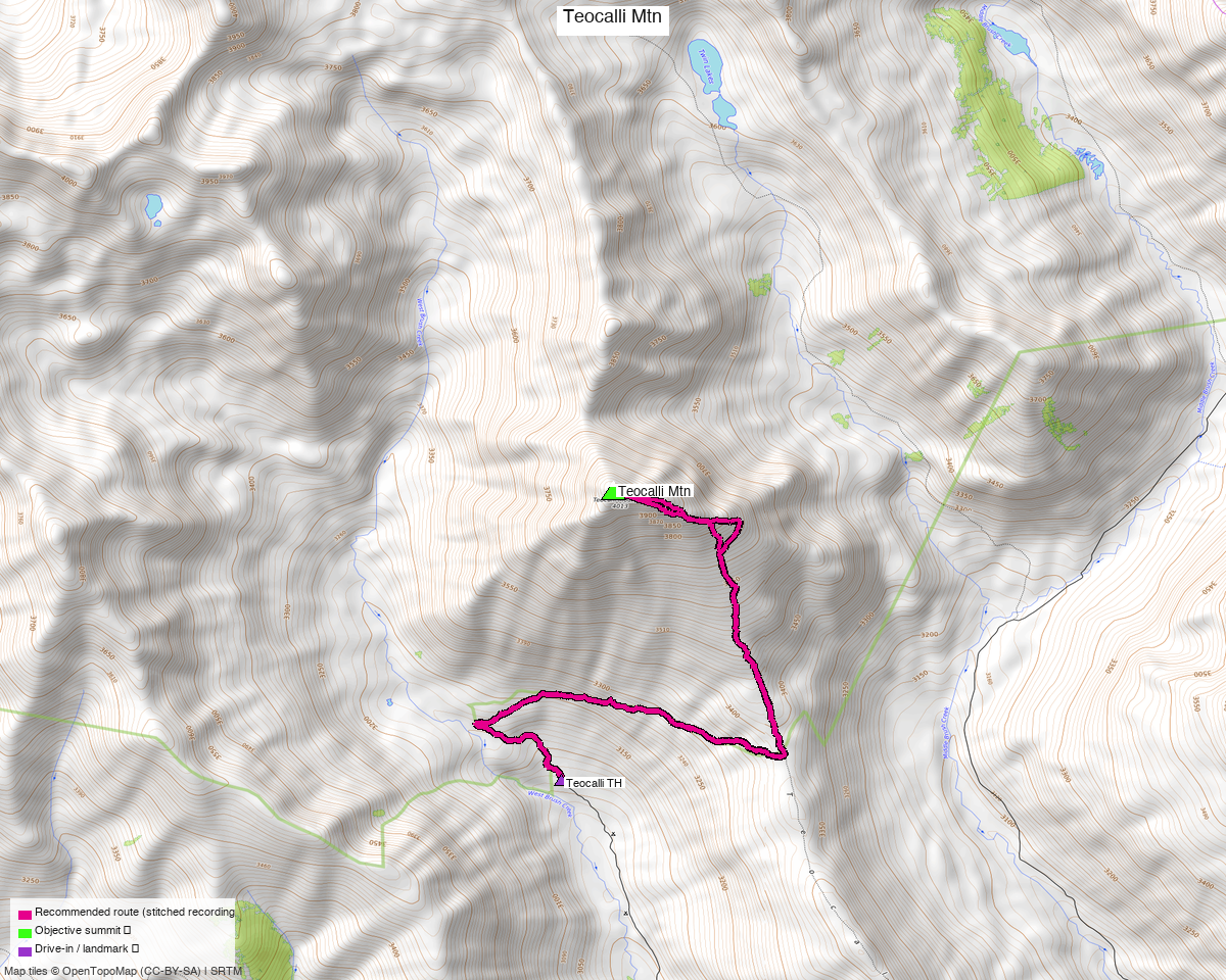
Note: the recommended route was distilled from 9 recorded GPS tracks of real trips (14ers.com · ListsofJohn · peakbagger) — all layered on the interactive CalTopo research map.
The peak
Teocalli Mountain, 13,213' (LiDAR) — Gunnison County, Elk Mountains, the prominent pyramid east of Crested Butte above Brush Creek. listsofjohn rates it Class 1+, and that is honest: a maintained trail runs to 12,420'.
This is the easiest day in the Elk group by a wide margin — six miles and three thousand feet, on a trail for most of it, in a range where the neighbouring reports are Class 3 and 4 on rotten rock.
Summit note. peak_db's coordinate sat 146 ft off and 49 ft low. The marker was relocated from the highest lingered point across 8 recorded tracks, landing at 38.96056, −106.88439 — within 13 ft of listsofjohn's LiDAR coordinate, so two independent methods agree.
The recommended route — 6.1 mi / 3,064 ft
An out-and-back from the Teocalli TH (10,058'):
| Leg | Distance | On trail | Source |
|---|---|---|---|
| TH → Teocalli Mountain | 3.05 mi | 52% | trk_loj_16216 |
| Teocalli Mountain → TH | 3.01 mi | 45% | trk_14ers_1 |
The two legs share 98% of their ground — this is a true out-and-back, and the composed line simply takes the cleanest recording in each direction.
The sequence, from the beta
- Teocalli Trail No. 554 from the trailhead — Class 1, but "overgrown with plants, so at times it was hard to see."
- At 0.65 mi, a junction: turn right and follow the trail east.
- At the next junction, 1.5 mi on and "clearly marked": turn left, north.
- At 12,420' the maintained trail ends and it becomes Class 2.
- Head west to the summit — "Route finding was easy, and I even found a few cairns along the way."
Getting there — Teocalli Trailhead
| Drive from Boulder | ~6h 25m via Google Maps — Crested Butte, then Brush Creek Road. |
| Trailhead | Teocalli TH, 38.94447, −106.88760, 10,058'. |
| Road | The road is the hardest part of this trip, and the beta is vivid about it. |
| Land | Gunnison NF. The access sweep found only the Crested Butte ski areas and the Rocky Mountain Biological Laboratory, neither near the route. |
The last two miles of road, and the commitment problem
"The drive in to the Teocalli Trailhead was sketchy. My stock Tacoma made it, but the last 2 miles were brutal, and the last quarter of a mile I kept going because I had to and couldn't turn around if I'd tried." — 14ers TR 21779
That last clause is the one that matters: there is a section you cannot back out of. Decide before you commit.
If you don't want the road, the cost is severe. Three recorded tracks start from the lower Brush Creek area at 9,192' — 866 ft lower — and they run 13.7 to 14.6 miles instead of 6.1. Not driving the rough section more than doubles the day.
Also: bring bug spray. "There were a ton of flies and mosquitoes out. The flies looked like normal flies, but when they bit me, I got welts. The next day they looked like burns."
Do not confuse this with the ridge north of the summit
Several recorded tracks continue north from Teocalli over PT 12,934, PT 13,162 and Triangle Peak. That link-up is a completely different proposition:
"You need to be very comfortable with class 4 climbing and exposure, as well as bushwhacking through trees/brush/willows. There is a knife edge that puts the one on Capitol to shame, and several class 4 chimneys."
The route in this report turns around on the summit. If the tracks on the research map appear to keep going north, that is why.
Gear & season
- Best window: July through September; the recorded pool is June to October. The trail is overgrown in midsummer, which is a nuisance rather than a hazard.
- Terrain: Class 1 trail to 12,420', then Class 2 for the last 800 ft with cairns.
- Bugs: unusually bad by the beta's account — see above.
- Vehicle: the real gatekeeper. High-clearance 4WD, and be sure before the last quarter mile.
Other considerations
White Rock Mountain + White Benchmark are 2.7 miles away and are the natural pairing — and usefully, three of their recorded tracks start from this same upper Brush Creek trailhead. That report recommends the Copper Creek/Judd Falls side (identical drive time, better-mapped parking), but if you would rather do both objectives from one base, Brush Creek serves both. The two trailheads are 51 minutes apart by road either way, so a weekend from Crested Butte works however you split it.
The bigger day, if you want it. Two recorded parties link Teocalli north into a six- or seven-peak outing including "Triangle Peak" (13,405', unclimbed) — 16.7 mi and 5,244 ft for WildWanderer's version. Read the danger box first: that is Class 4 with a knife edge, not an extension of this walk-up.
Trip reports & GPX (all three sources)
All three sources swept and deduped, plus the mapped OSM trail network — all layered on the research map.
- 14ers.com: peak 10124 — 5 GPX-library tracks from 8 trip reports. No formal route description; the beta above is from trip reports.
- listsofjohn.com: peak 599 — Class 1+; 3 tracks from 4 trip reports. LoJ cross-verified the peakbagger id: 19745.
- peakbagger.com: peak 19745 — 1 ascent track with GPS (plus 2 duplicates of another source).
Sources checked: 14ers.com ✓ · listsofjohn.com ✓ · peakbagger.com ✓