Graystone + Electric + Mt Garfield — the Grenadiers Kyle still needs (Class 3)
Other climbers: Emily Sharpe — not yet · Shawn D Keil — not yet
At a glance — 2-day trip
3 peaks · ~8.54 h drive
- Day 1 (grenadier_trio): 11.3 mi · 5,791 ft gain
- Day 2 (pack_in_pack_out): 7 mi · 1,177 ft gain
NOAA weather link: Grenadier Range Weather
CalTopo research map: https://caltopo.com/m/VS3MNQ1
Researched: 2026-08-01
Status in Peak Checklist: all three unclimbed.
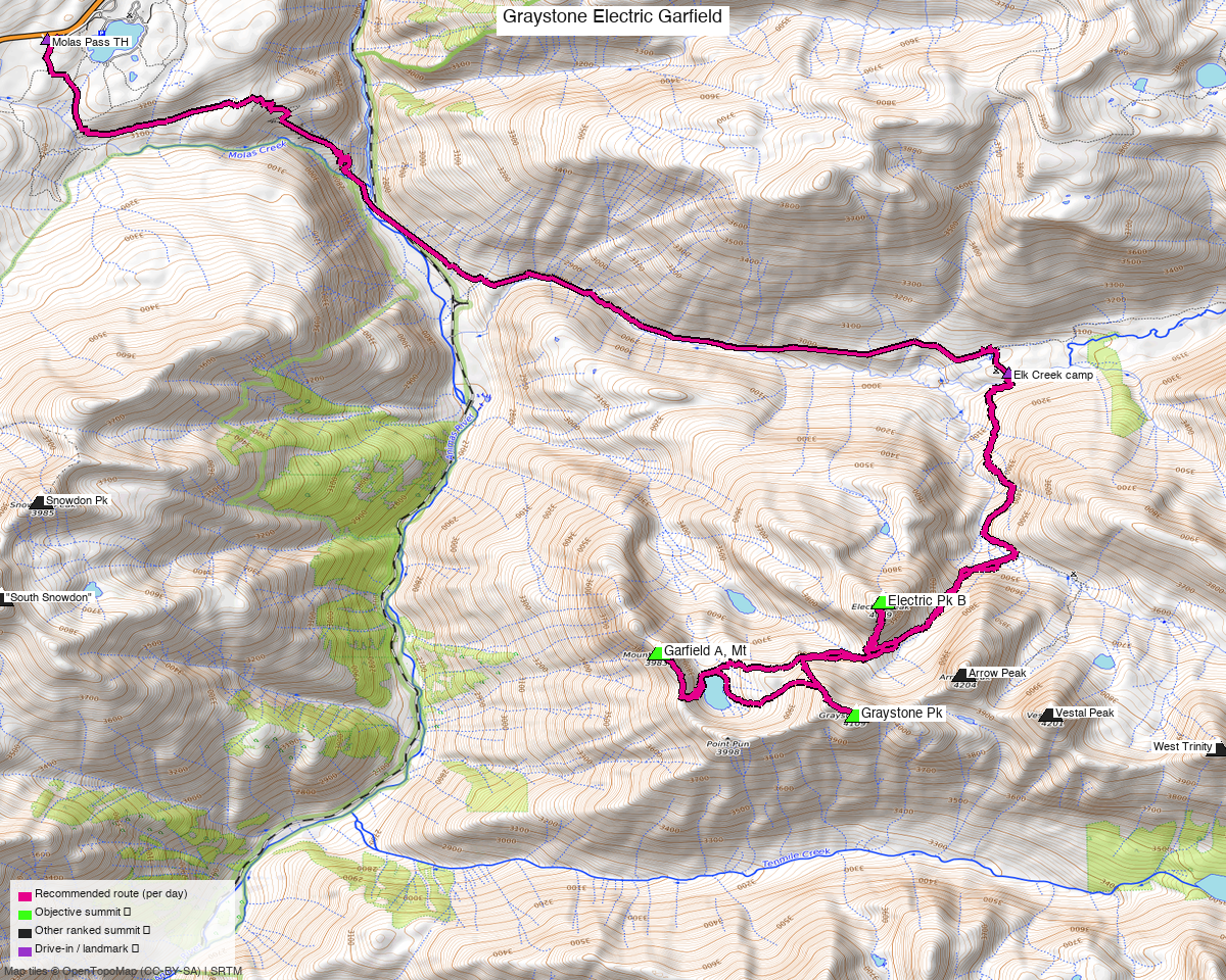
Note: the recommended route was distilled from 25 recorded GPS tracks of real trips (14ers.com · ListsofJohn · peakbagger · Kyle's recordings) — all layered on the interactive CalTopo research map.
Nobody does this from the car
That is the finding, and it shaped the whole report. compose_best_route could not build a route
from Molas Pass at all — not one recording in the pool links the trailhead to any of these three
summits in a single piece, because every party that climbs them is already camped in the
Weminuche when their climbing day starts.
The recordings sort into exactly three kinds:
| From an Elk Creek camp (~9,993') | trk_loj_8594 — 11.3 mi round trip, all three peaks, zero non-objective summits |
| From a basin camp (11,406') | trk_pb_1 — 9.4 mi round trip, all three, but 1,400 ft higher in |
| Multi-day traverses | 32.0, 55.2, 73.1 and 77.8 mi, collecting 25+ summits including Arrow, Vestal and the Trinities |
So this is a backpack, and the report is built as one.
Peaks covered
| Peak | Elev | Class |
|---|---|---|
| Graystone Pk | 13,503' | 2 |
| Electric Pk B | 13,297' | 2 |
| "Garfield A", Mt | 13,087' | 3 |
La Plata / San Juan counties — Weminuche Wilderness, Grenadier Range, the south side of Vestal Basin.
Kyle has already been here. Arrow, Vestal, the Trinities, Storm King and the Peak Six/Seven group are all ticked from this same basin — these three are what is left on the south side.
The trip — ~25.3 mi walked over 2 days
The figures in the box above are 18.3 mi of distinct line, because the pack-in and pack-out share one corridor and it is drawn once. Walked, the trip is 7.0 mi in + 11.3 mi climbing + 7.0 mi out ≈ 25.3 mi.
Pack in / pack out — 7.0 mi · 1,177 ft each way
Molas Pass to an Elk Creek camp at ~9,993'. Gentle by Weminuche standards: the Colorado Trail drops off Molas and picks up Elk Creek, and the whole leg gains barely 1,200 ft. The same line comes back out, which is why it appears once on the map and once in the stats.
Climbing day — 11.3 mi / 5,791 ft
trk_loj_8594 ridden verbatim, in the order that party walked it: Electric Pk B → Graystone Pk
→ Mt Garfield. It is taken whole rather than stitched because it is the only recording in the
pool that tours all three objectives without crossing a single non-objective ranked summit —
everything else wanders onto Arrow, Vestal or the Trinities. Max point gap 0.03 mi, so it is a
clean, densely-sampled track.
Mt Garfield is the Class 3 summit and comes last on the day; the other two are Class 2.
5,791 ft of gain in 11.3 mi from camp is the real number to plan around — this is a big day even before you account for it being day two of a backpack.
Getting there
| Drive from Boulder | ~8h 35m via Google Maps |
| Trailhead | Molas Pass TH, 37.7476, −107.6885, 10,608' — mapped parking off US 550 via Molas Trailhead Rd (FR 680). Any vehicle. |
| Wilderness | Weminuche Wilderness — no permits, standard LNT, and no mechanised anything. Bear canister recommended. |
| Access sweep | No restricted or private land found anywhere in the box. |
Gear & season
- Best window: July through September. Every recording in the pool is July or August.
- Terrain: Class 3 on Garfield, Class 2 on Graystone and Electric; classic loose Grenadier quartzite.
- Helmet: yes.
- Cell: none. This is as deep as Colorado gets — carry a satellite messenger.
Other considerations
The train is the other way in. The Durango & Silverton narrow gauge stops at Elk Park, at the bottom of Elk Creek, and many parties use it instead of walking from Molas. No recording in this pool uses it, so it is not costed here — but it is worth pricing if the 7 mi pack-in each way is the part you would rather skip.
There is more left in this basin. Beyond these three, "The Heisspitz" (13,268', Class 3), Peak Four, Peak Five and PT 13,252 are all still unclimbed and all within about 2.6 mi. With a camp already established and an 8.5-hour drive behind you, a third day is cheap — the 32–78 mi traverse recordings in the pool exist precisely because parties link these together.
Trip reports & GPX (all three sources)
All three sources swept across all three objective peaks and deduped, plus the mapped OSM trail network — all layered on the research map.
- 14ers.com: peaks 10382, 10468, 10574 — 1 GPX-library track.
- listsofjohn.com: peaks 328, 505, 746 — 3 tracks from 15 trip reports. LoJ cross-verified the peakbagger ids: 19800 / 19787 / 82540.
- peakbagger.com: peaks 19800, 19787, 82540 — 2 ascent tracks with GPS (plus 7 duplicates).
Sources checked: 14ers.com ✓ · listsofjohn.com ✓ · peakbagger.com ✓