Italian Mtn — Elk, Class 2
Other climbers: Emily Sharpe — not yet · Shawn D Keil — ✓ climbed
At a glance — recommended day
11 mi · 3,355 ft gain · Class 2 · 1 peak · ~5 h drive
NOAA weather link: Italian Mountain Weather
Drive from Boulder: ~5h via Google Maps
CalTopo research map: https://caltopo.com/m/GB2R1R0
Researched: 2026-07-23
Status in Peak Checklist: unclimbed. A ranked Elk Range 13er (13,385', ~1,357' prominence) northeast of Taylor Park / south of Pearl Pass — the high point above the head of Cement Creek. Originally drafted alongside Star + Taylor, but it's a separate trailhead and drainage (Cement Creek, Gunnison side) so it stands as its own climb.
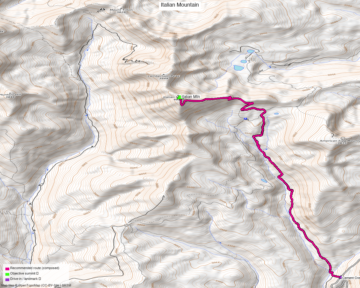
Note: the recommended route was distilled from 7 recorded GPS tracks of real trips (14ers.com · ListsofJohn · peakbagger) — all layered on the interactive CalTopo research map.
Peaks covered
A single Class 2 Elk Range 13er — tundra and talus, no scrambling above walk-up. The whole difficulty is distance, altitude, and the access road, not the terrain.
| Peak | Elev | Class | Prom | CO rank |
|---|---|---|---|---|
| Italian Mtn | 13,385' | 2 | ~1,357' | ~#331 |
Italian sits in the Elk Mountains (Pearl Pass quad), Gunnison County — GMUG NF, no wilderness designation at the summit, no permits/fees. Beautiful high wildflower country at the head of Cement Creek, with a stellar view across to Star Peak.
Getting there — Cement Creek (CR 740)
| Drive from Boulder | ~5h via Google Maps (origin: 1162 Peakview Circle) — via US-285 / US-50 to Gunnison, north on CO-135, then CR 740 (Cement Creek Rd). |
| 2WD start (this route) | ~38.8923,-106.7184, ~10,460' — where the recorded track starts; the sane stopping point for a passenger car / where the road gets rough. |
| 4WD trailhead | climb13ers' Cement Creek – Italian Mtn TH at 10,780' (N38°56'24.63" W106°46'18.12"), 4×4 / high-clearance recommended — driving to here cuts the day to ~4 mi / ~2,595 ft RT. |
| Alternate | Without 4WD you can also approach via FR 759 north of Taylor Park Reservoir. |
Route — Cement Creek to the summit (Class 2)
~11.4 mi · ~3,350 ft round trip from the 2WD start — the recommended line is optimized from the recorded Cement Creek ascent, trimmed of the extra 12er and add-on peaks that party bagged (you just want Italian). This is the long no-4WD haul; 4WD to the higher TH roughly thirds it — climb13ers has it at ~4 mi / ~2,595 ft. The line follows Cement Creek Rd / the drainage NW up toward the head of the valley, then climbs Italian's broad south/southeast slopes to the summit — Class 2 tundra and talus throughout, no exposure. Return the same way.
climb13ers rates it a Class 2 "medium day, take a lunch." Pair it with the easy sub-13k American Flag Mtn or soft-ranked Lambertson Peak just south if you want more — several recorded parties do the group in one push.
Gear & season
- Best window: July–September — Cement Creek Rd and the upper basin melt out late; wildflowers peak mid-summer.
- Vehicle: high-clearance / 4WD strongly helps — it's the difference between a ~4 mi morning and a ~13 mi day. Passenger cars park low and hike the road.
- Terrain: Class 2 the whole way — no rope/axe/crampons in season. Above treeline for the upper half; early start, off the summit by early-afternoon monsoon.
- Cell: unreliable in the Cement Creek drainage — carry an InReach.
Other considerations
Why the long recorded line instead of the short 4WD figure? climb13ers' 4 mi / 2,595 ft is the 4WD version from the 10,780' TH. There's no recorded GPS track and no public trail on the South Ridge from that 4WD TH (the mapped NE "Italian Mountain Trail" off Italian Creek Rd appears to cross private land), so the honest data-backed recommended line is the recorded Cement Creek ascent from the 2WD start — longer, but real. If you have 4WD, drive to the 10,780' TH and expect the much shorter climb13ers day.
Not grouped with Star + Taylor. An earlier draft bundled Italian with Star + Taylor Peaks; those are climbed from the Mt Tilton Trail (end of CO 742) on the Taylor Park side — a different road system. Italian is its own trip from Cement Creek.
Trip reports & GPX (all three sources)
Sources confirmed logged in: 14ers.com ("Basin"), listsofjohn.com ("letsgocu"), peakbagger.com ("Kyle Knutson"). Italian's library was swept across all three sources; the peakbagger ascent track (Cement Creek approach) is the basis for the recommended route, layered on the research map with the 14ers-library track.
- 14ers.com: peak page 10110 — GPX-library track present (Mt Tilton / Star-side loop); no formal route description.
- listsofjohn.com: peak 420 — 5 trip reports, text only (no downloadable GPX).
- peakbagger.com: peak 16662 — ascent GPX (Cement Creek) used for the route.
- climb13ers.com: Italian Mountain South Ridge — Class 2 route + trailhead beta.
Sources checked: 14ers.com ✓ (logged in, "Basin") · listsofjohn.com ✓ (logged in, "letsgocu") · peakbagger.com ✓ (logged in, "Kyle Knutson")