West Willow / La Garita 2-Day — 5 ranked 13ers above Creede (Class 3)
Other climbers: Emily Sharpe — not yet · Shawn D Keil — 3 of 5 (Baldy Lejos, PT 13,115, PT 13,030)
At a glance — 2-day trip
5 peaks · ~5.73 h drive
- Day 1 (West three (Baldy Lejos + 13,115 + 13,030)): 11.86 mi · 2,961 ft gain · Class 2 · 3 peaks
- Day 2 (East two (13,308 + 13,166)): 9.11 mi · 3,030 ft gain · Class 3 · 2 peaks
NOAA weather link: West Willow / La Garita Weather
Drive from Boulder: ~5h 45m / 284 mi via Google Maps
CalTopo research map: https://caltopo.com/m/8PR7TM3
Researched: 2026-08-06
Status in Peak Checklist: all five climbed — this rebuilt report documents the efficient two-day car-camp version for partners or a repeat, from one trailhead above Creede.
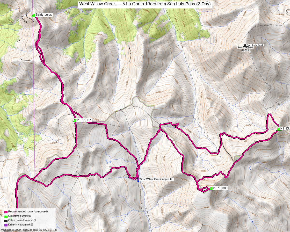
Note: the recommended route was distilled from 18 recorded GPS tracks of real trips (14ers.com · ListsofJohn) — all layered on the interactive CalTopo research map.
Peaks covered
Five ranked 13ers in the La Garita Mountains north of Creede — the West Willow Creek / San Luis Pass corridor of the Colorado Trail. Rio Grande NF; no permits or fees.
| Peak | Elev | Class | CO rank | Day | Status |
|---|---|---|---|---|---|
| "Baldy Lejos" | 13,118' | 2 | 553 | 1 | climbed |
| PT 13,115 | 13,115' | 2 | 556 | 1 | climbed |
| PT 13,030 | 13,030' | 2 | 619 | 1 | climbed |
| PT 13,308 | 13,308' | 2 | 394 | 2 | climbed |
| PT 13,166 | 13,166' | 3 | 511 | 2 | climbed |
The split is geographic: the three western peaks share one crest west of the trailhead; 13,308 and 13,166 sit east of it. One camp at the TH, one drainage climbed per day, no re-crossing — 21.0 mi / 5,991 ft total, and the two days come out nearly identical in effort (11.9 mi/3,000 ft vs 9.1 mi/3,000 ft).
Day 1 — the west three ⭐
11.86 mi · ~2,961 ft, Class 2 — Baldy Lejos → PT 13,115 → PT 13,030, composed per-leg from the recorded traverses of the western crest (six parties recorded this ground). The walking is Class 2 tundra and talus throughout — the La Garita crest is broad and gentle by San Juan standards.
Day 1 sequence
- From the West Willow Creek TH (11,503'), climb west to the crest.
- Baldy Lejos (13,118'), then south along the ridge to PT 13,115.
- Continue to PT 13,030 (13,030') and descend back to the trailhead.
Day 2 — the east two, with the Class 3 crux
9.11 mi · ~3,030 ft, Class 3 — PT 13,308 and PT 13,166 east of camp, the pairing one 2019 party recorded as a single day. PT 13,166's summit block is the trip's only Class 3 ground (LoJ rates the peak 3); hands out for the final moves, a helmet is reasonable, no rope. The approach to 13,308 crosses braided climber's lines on open slope — the drawn route takes the efficient line through them.
Day 2 sequence
- From the TH, head northeast toward the San Luis Pass corridor.
- PT 13,308 (13,308') — the trip's highpoint, Class 2 via the braided west slopes.
- Traverse east to PT 13,166 (13,166') — Class 3 summit block.
- Descend back to camp.
Getting there — West Willow Creek TH (11,503')
| Drive from Boulder | ~5h 45m / 284 mi via Google Maps — Google resolves this destination as "West Willow Creek Trailhead, Creede" by name. (OSRM's conservative rough-road estimate says ~9h; the Maps figure is the realistic one.) |
| Trailhead | West Willow Creek TH, 37.95518, −106.96651, 11,503' — an OSM-named parking area; 9 of the 18 recorded tracks start on it |
| Road | West Willow Creek Rd out of Creede — ground surface, tracktype grade2–3; high clearance recommended, ordinary-SUV territory in dry conditions. The last stretch is the slow part, not the highway miles. |
| Camping | Dispersed at and near the TH — the one-camp, two-day rhythm is the point of this trip. |
Gear & season
- Best window: late June through September. 13 of the 18 recordings are summer or shoulder; the June recordings suggest the crest melts out early for the San Juans.
- Terrain: Class 2 everywhere except PT 13,166's summit block (Class 3) — helmet for that block, trail shoes otherwise.
- Altitude: camp at 11,500' and both days stay high — good acclimatization trip, bad first-weekend-of-the-season trip.
- Storms: both days are open crest — standard alpine starts; the balanced split means neither day forces a long committed stretch.
- Cell: Creede has service; assume none up the drainage — InReach as usual.
Other considerations
Why west 3 / east 2: the split is the geography — one crest west of camp, two summits east of it, no day re-crosses the other's ground, and the two days balance almost exactly (≈3,000 ft each). Recorded alternatives exist (three parties walked a 4-peak day linking the west crest to 13,308 at 20.8–23.8 mi walked), but that shape front-loads a 5,000 ft day and leaves a stub second day; the geographic split is simply the more effective optimization.
Composed vs recorded mileage, stated plainly: the drawn lines are stitched per-leg from the recordings (best ascent, best link, best descent) and run shorter than any single party's walked day. Same recorded ground throughout — but budget time above the floor, per usual.
Trip reports & GPX (all three sources)
Sources confirmed logged in: 14ers.com ("Basin"), listsofjohn.com ("letsgocu"), peakbagger.com ("Kyle Knutson"). All three swept fresh for this rebuild, plus the mapped OSM trails in the corridor — all layered on the research map.
- 14ers.com: peak pages 10562 / 10554 / 10591 / 10461 / 10534 — 13 GPX-library tracks, the deepest coverage of the three sources.
- listsofjohn.com: peaks 714 / 701 / 788 / 510 / 648 — 22 trip reports seen, 5 member tracks harvested plus 3 duplicates; LoJ cross-verified all five peakbagger pids.
- peakbagger.com: peaks 84932 / 84934 / 84927 / 39888 / 39886 — 6 ascent tracks found, all duplicates of recordings already harvested from the other two sources (recorded in sources.json).
Sources checked: 14ers.com ✓ (logged in, "Basin") · listsofjohn.com ✓ (logged in, "letsgocu") · peakbagger.com ✓ (logged in, "Kyle Knutson")