Mt Daly — Capitol Creek to the SW ridge (Elk, Class 2)
Other climbers: Emily Sharpe — not yet · Shawn D Keil — not yet
At a glance — recommended day
14.5 mi · 4,049 ft gain · Class 2 · 1 peak · ~5.19 h drive
NOAA weather link: Mt Daly Weather
CalTopo research map: https://caltopo.com/m/PCG100E
Researched: 2026-07-28
Status in Peak Checklist: unclimbed. A ranked Elk Range 13er (13,323', CO rank ~375) on the ridge northeast of Capitol Peak — which you have already climbed, so the optional add-on below is a repeat, not a new tick. Daly shares Capitol's trailhead and most of its approach trail, which is what makes the pairing natural.
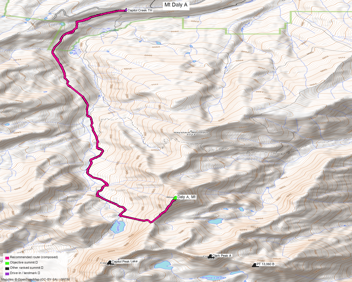
Note: the recommended route was distilled from 31 recorded GPS tracks of real trips (14ers.com · ListsofJohn · peakbagger · Kyle's recordings) — all layered on the interactive CalTopo research map.
Peaks covered
One Class 2 Elk 13er. The whole day is distance and altitude on a good trail, then a straightforward ridge — no scrambling above walk-up on Daly itself.
| Peak | Elev | Class | CO rank | Status |
|---|---|---|---|---|
| Mt Daly | 13,323' | 2 | ~375 | unclimbed |
| Capitol Peak (optional add-on) | 14,138' | 4 | 29 | ✓ climbed |
Daly sits in the Elk Mountains (Capitol Peak quad), Pitkin County — Maroon Bells–Snowmass Wilderness, White River NF. No permit is needed to climb; camping at Capitol Lake is a different story (see below).
Summit note: peak_db's coordinate for Daly sat ~79 ft off and ~63 ft low. The marker on the map is the corrected summit, located from the convergence of 5 independent recorded tracks.
Recommended route — Capitol Creek to the SW ridge ⭐
~14.5 mi · ~4,050 ft round trip, Class 2, from the Capitol Creek TH (9,450').
The line follows the Capitol Creek Trail south up the drainage toward Capitol Lake, then leaves the lake basin to gain Daly's southwest ridge and follows it to the summit. climb13ers rates the climb Class 2 and calls it "a long day-hike using the same trail as for the 14er, Capitol Peak." Return the same way.
Two things worth knowing about how this route was built. The best Capitol Creek recordings are combined Daly + Capitol trips — 14ers trip 18629 appears in both peaks' GPX libraries and runs 18.8 mi; a peakbagger ascent of the same pairing runs 21.0 mi. Following either verbatim would fold Capitol's Class 4 summit day into what should be a Class 2 outing, so the recommended line is composed to Daly alone and comes out ~4–6 mi shorter than those tracks.
Approach options:
| Option | Trailhead | Distance | Notes |
|---|---|---|---|
| Capitol Creek (recommended) | Capitol Creek TH, 9,450' | ~14.5 mi | The standard approach — same trail as Capitol Peak; what the beta describes |
| Snowmass Creek | ~39.200, −106.994, ~8,400' | ~15.4 mi recorded | A real alternate — three recorded tracks come in from this side. Lower start, so more gain |
Route sequence
- From the Capitol Creek TH (9,450'), take the Capitol Creek Trail south up the drainage (the ditch-road start drops to the creek before climbing — it is the standard line).
- Continue toward the Capitol Lake basin (~11,600').
- Leave the basin to gain Daly's SW ridge, and follow it northeast to the 13,323' summit.
- Reverse the route. Budget a long day — the mileage, not the terrain, is the difficulty.
Optional add-on — Capitol Peak (Class 4, already climbed)
Capitol Peak is Class 4 — the Knife Edge
Capitol's standard route is Class 4 with the Knife Edge: a knife-thin, badly exposed granite ridge with drops on both sides, and the peak has a long fatal-accident history — routinely called one of Colorado's hardest and most dangerous 14ers. It is a completely different undertaking from Daly's Class 2 day: helmet, genuine comfort on exposed Class 4 downclimbing, an early start, and dry rock with a stable forecast. Do not treat it as "a bit more" on the end of Daly.
You have already climbed Capitol, so this is a repeat rather than a new summit — worth it for the route itself, not the tick. It shares the Capitol Creek approach, and 18 recorded Capitol tracks are layered on the research map as context, so the approach and the ridge are both well covered if you want to look at how parties actually did it.
Realistically these are not one day together. Parties who bag both use a camp in the basin and climb them on separate days, which runs straight into the permit constraint below.
Getting there — Capitol Creek TH (rough 2WD)
| Drive from Boulder | ~5h 15m via Google Maps (~214 mi) — I-70 west to Glenwood Springs, CO-82 to Carbondale, then Capitol Creek Rd |
| Trailhead | Capitol Creek TH, 39.23422, −107.07952, 9,450' (14ers TH page er05) |
| Road | Difficulty 2 — 2WD, rough dirt, good clearance. Rough 2WD to the horse-trailer parking about 2 mi below the TH, then steeper on the final section. AWD/4WD recommended in early summer, when the steep pitch gets slippery. |
| Parking | Weekend parking is a known problem here (climb13ers). Start early or come midweek. |
Camping at Capitol Lake requires a reservation. Permits are small in number and go through recreation.gov; dispersed camping has to sit outside the "Capitol Lake Zone," roughly 2 mi below the lake. That is precisely why Daly is worth doing as a long day-hike — it avoids the permit lottery entirely.
Gear & season
- Best window: July through September. The Capitol Creek road melts out and dries by early summer; the SW ridge wants dry rock.
- Terrain: Class 2 throughout on Daly — trail, tundra and talus. No rope, axe or crampons in season.
- Vehicle: good ground clearance for the last 1.5 mi; AWD/4WD helps in early summer.
- Storms: standard Elk Range afternoon monsoon exposure once you are on the ridge — early start, off the high ground by early afternoon.
- Cell: unreliable in the Capitol Creek drainage — carry an InReach.
Other considerations
Why not from_track? Every strong Capitol Creek recording here is a Daly + Capitol trip, so the recommended line is composed to Daly alone rather than inheriting someone else's Class 4 add-on. See the route section above.
One foreign track in the pool. Among Capitol's context tracks, one recording starts at 38.960, −106.461 — Huron Peak in the Sawatch, ~40 mi away. It is mis-tagged upstream, not Elk Range beta, and it does not contribute to the recommended line.
Nearby ranked peaks are done. Capitol is climbed, so there is no unclimbed ranked neighbor to pair Daly with from this trailhead — it stands as its own day.
Trip reports & GPX (all three sources)
Sources confirmed logged in: 14ers.com ("Basin"), listsofjohn.com ("letsgocu"), peakbagger.com ("Kyle Knutson"). Daly's library was swept across all three, plus Capitol Peak as a context peak for approach beta, plus the 31 mapped OSM trails in the drainage — all layered on the research map.
- 14ers.com: peak page 10117 — 1 GPX-library track (trip 18629, a combined Daly + Capitol outing). No formal 13er route description.
- listsofjohn.com: peak 490 — 3 trip-report tracks, including two from the Snowmass Creek side.
- peakbagger.com: peak 55299 — 2 ascent tracks (one Capitol Creek, one Snowmass Creek).
- climb13ers.com: Mount Daly SW Ridge — Class 2 rating, trailhead beta and the "long day-hike" framing used above.
Sources checked: 14ers.com ✓ (logged in, "Basin") · listsofjohn.com ✓ (logged in, "letsgocu") · peakbagger.com ✓ (logged in, "Kyle Knutson") · climb13ers.com ✓