Trip: Gold Dust Group 2-Day (Gold Dust+Pika / Finnegan) — Holy Cross Wilderness Sawatch
Other climbers: Emily Sharpe — not yet · Shawn D Keil — not yet
At a glance — 2-day trip
3 peaks · ~4.35 h drive
- Day 1 (gold_dust_pika): 12.3 mi · 4,542 ft gain · Class 3 · 2 peaks
- Day 2 (finnegan): 8.1 mi · 4,946 ft gain · Class 3 · 1 peak
NOAA weather link: Trip: Gold Dust Group 2-Day (Gold Dust+Pika / Finnegan) — Holy Cross Wilderness Sawatch Weather
Drive from Boulder: ~4h 25m via Google Maps
CalTopo research map: https://caltopo.com/m/GSP1K50
Researched: 2026-08-07
Status in Peak Checklist: unclimbed. All three peaks are unclimbed ranked 13ers (CO ranks 324, 353, 545) standing on one north–south ridge in a Holy Cross Wilderness pocket Kyle hasn't touched — one drive west clears the entire Gold Dust ridge in a single trip.
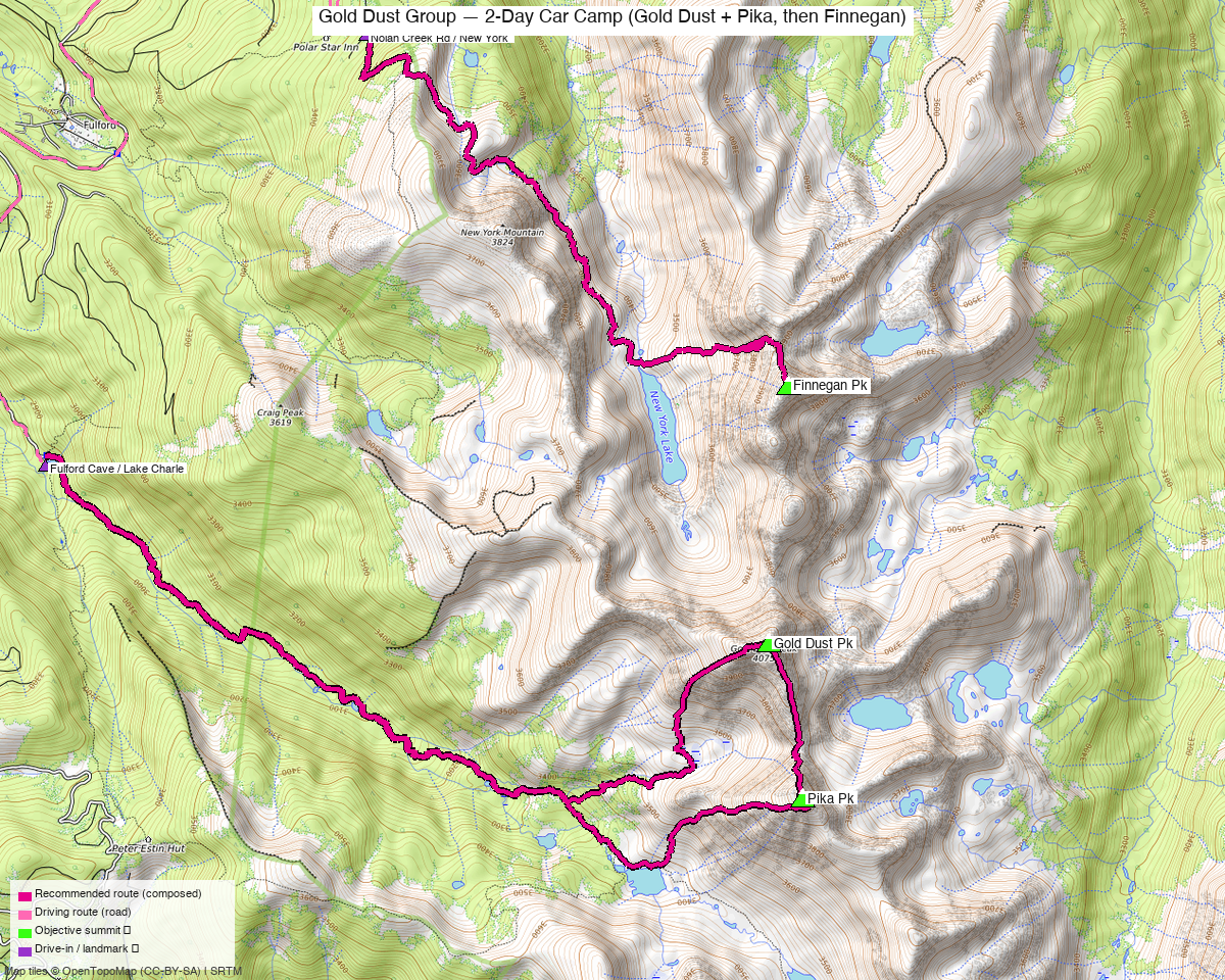
Note: the recommended route was distilled from 17 recorded GPS tracks of real trips (14ers.com · ListsofJohn · peakbagger) — all layered on the interactive CalTopo research map.
Peaks covered
The Gold Dust group is a single north–south ridgeline in the northern Sawatch east of Eagle, inside the Holy Cross Wilderness (White River National Forest): "Finnegan Pk" (the unofficial name for UN 13,352, also called "North Gold Dust") at the north end, Gold Dust Pk in the middle, and "Pika Pk" 0.77 mi to its south. Two forest-road corridors off the same Brush Creek road system serve the group — FR415 to the Fulford Cave / Lake Charles TH on the southwest, and FR418/Nolan Creek Road to the 11,210' New York Mountain TH on the northwest — which is what makes the two-day split clean: one trailhead per day, a short reposition between them. No permits or fees; standard wilderness rules apply (group size limits, no drones, no mechanized travel).
| Peak | Elev | Class | CO rank | Day | Status |
|---|---|---|---|---|---|
| Finnegan Pk | 13,352' | 3 | 353 | 2 | unclimbed |
| Gold Dust Pk | 13,398' | 2+ | 324 | 1 | unclimbed |
| Pika Pk | 13,130' | 2+ | 545 | 1 | unclimbed |
Day 1 — gold_dust_pika
12.3 mi · ~4,542 ft, Class 3 — a proper loop, stitched from the two best recordings: in on the Lake Charles Trail #1899, up Pika's west ridge, then north along the direct connecting ridge to Gold Dust — the "extended Class 3" crest (Gary Neben's rating; the 2024 recording that walked it spent real time in the blocky notch at the ~12,565' saddle) — and out down Gold Dust's rounded west ridge into Negro Basin, rejoining the trail. The ridge is the recommended line (Kyle's call, and it's shorter with less gain); the easier out is documented below. Terrain above the trail is talus and broken rock throughout — climb13ers calls Gold Dust's flank "a long slugfest" — with the only real scrambling on the connecting crest.
Easier alternative (Class 2+, ~+870 ft): skip the connecting ridge — from Gold Dust's west ridge at ~12,400', drop into Negro Basin (bottoming ~11,700' in the marshy meadow), cross it, and take Pika's west-ridge slope-and-trough instead (or the reverse). This is the line the climb13ers party took when storms were brewing (~1.5 h summit to summit) and the one recorded in the 2023 track; the direct ridge took its 2024 party a slow scramble and Neben budgets it "up to three hours."
Day 1 sequence
- Fulford Cave / Lake Charles TH (9,440') — from the SE end of the parking area, follow the road bed to the signed fork and take the left fork, Lake Charles Trail #1899 (right is the Iron Edge trail past cabins — wrong way).
- Up East Brush Creek on good trail — flattish for the first ~2.5 mi, then climbing past the unnamed lake at 10,820' (~3.5 mi in).
- Continue toward the head of the valley and leave the trail below Pika's west ridge; ascend the well-defined slope-and-trough (~300 ft) onto the flat, narrow finger of the ridge at ~12,000'.
- Pika Pk (13,130') — medium boulder rubble up the west ridge, similar to Gold Dust's flank but less rocky.
- The connecting ridge north to Gold Dust — the Class 3 crux. ~0.8 mi of blocky crest, low point ~12,565'; hold the crest the whole way (the recorded line never leaves it). Budget generous time — the recording moved at a crawl through the saddle notch, and Neben's report allows up to three hours.
- Gold Dust Pk (13,398') — cross the 13,365' east summit en route; the west summit is the true one. Views straight down on New York Lake.
- Descend the rounded west ridge / SW flank — ~1,400 ft of medium broken rock — into Negro Basin, cross the meadow along the stream, and rejoin the Lake Charles Trail near the 10,820' lake.
- Trail back out to the TH. Day total: 12.3 mi / ~4,542 ft.
Day 2 — finnegan
8.1 mi · ~4,946 ft, Class 3 — the west approach from the 11,210' New York Mountain TH (4x4 for the last 0.7 mi past the Polar Star Hut switchback; ~5h from Boulder, 1h+ from Eagle). Don't let the mileage fool you: the gain is real and the recordings prove it — the approach is a rolling ~11,300' bench traverse with constant ups and downs that are all regained on the return, plus a steep drop through a cliff break each way, so the 2025 recorded day banked 4,975 ft, right on the built line's 4,946. The climb itself is the burliest of the trip: ~1,000 ft of rock-glacier boulder-hopping above New York Lake into a loose couloir ("watch for falling mountains" — climb13ers), escaping right onto more stable Class 3 blocks below the saddle, with moderate exposure in short sections. Helmets on, spread out from partners in the couloir.
Day 2 sequence
- New York Mountain TH (11,210') — Trail #1876 south past the old Polar Star Mine, then left (east) on the old mining road up to treeline and an open grassy meadow.
- Branch onto Trail #2221 where it heads east to the cliff edge; it drops steeply through a break in the cliffs, then levels onto the bench.
- Bench traverse ~2 mi south at ~11,300' beneath New York Mountain — faint tread, cairns where it fades, endless minor ups and downs past rivulets, ponds and tree pockets. This rolling ground is where the day's gain piles up.
- Drop to the New York Lake outlet (the lake stays hidden until you're on it — Gold Dust's north face above it is the view of the trip). Scout the ascent line before crossing the stream.
- East up the rock glacier — ~1,000 ft of boulder-talus — aiming for the main couloir toward the saddle north of the summit.
- The couloir: ~600 ft, steadily steeper and looser. 200–300 ft below the saddle, veer right (SE) onto larger, more stable fractured blocks — Class 3 over short gullies and cliff bands — to gain the north ridge.
- Finnegan Pk (13,352') — south along the ridge on tedious but stable boulder talus to a summit of broken rock, nowhere comfortable to sit.
- Return the same way — the bench's ups and downs come back out of your legs on the way home. Day total: 8.1 mi / ~4,946 ft.
Getting there — Fulford Cave / Lake Charles TH (9,440')
| Drive from Boulder | ~4h 25m via Google Maps |
| Trailhead | Fulford Cave / Lake Charles TH, 39.49225, -106.65922, 9,440' |
| Road | Eagle → Sylvan Lake Rd → Brush Creek Rd (CR307/FR400) 11.8 mi → left on FR415 (graded dirt) ~5.7 mi to Yeoman Park CG, then continue to the FR415 terminus. Only the last 2 mi past Yeoman Park are rough — high clearance preferred, though standard cars have made it (climb13ers; OSM: East Brush Creek Rd unpaved). Day 2's New York Mountain TH is up the Fulford road (FR418/Nolan Creek Rd) instead: good graded dirt to the Polar Star Hut switchback at 8.7 mi, then 4x4-only for the final 0.7 mi to the 11,210' TH. |
| Land | White River National Forest; the peaks and both trails are inside the Holy Cross Wilderness. No permits or fees; wilderness group-size limits apply. Fulford Cave TH gets heavy weekend day-use (cave hikers). |
Gear & season
- Window: July–September. 15 of 16 dated recordings are summer (Jul–Sep, 2013–2025); the one outlier is an October shoulder run. Both days go in that whole window.
- Early season is Finnegan's friend: climb13ers strongly recommends catching snow on the rock glacier and couloir — snow converts ~1,600 ft of loose boulder-hopping into a cramponable climb and a glissade descent. By late July it's bare (their party found none on July 31). Ice axe + microspikes/crampons if going before mid-July.
- Helmet both days: mandatory in Finnegan's couloir (loose, funneled), smart on the Gold Dust–Pika crest.
- Storms: the connecting ridge is the committing stretch — up to 3 hours of crest with no easy bail once past the saddle midpoint (the Negro Basin escape is from Gold Dust's west ridge, before or after, not mid-traverse). Summits by noon; the Fulford valley approach itself is sheltered.
- Footwear/terrain: almost everything above the trails is talus, blocky rubble, or embedded rock — stiff soles pay for themselves.
- Water: plentiful on both approaches (East Brush Creek, the bench's rivulets, New York Lake outlet); the ridgelines are dry.
- Mosquitoes at the New York Mountain TH are "quite voracious" through July (climb13ers, both visits) — camp accordingly.
Other considerations
- The recorded single-day option exists. One 2024 LoJ track does all three peaks in one 15.9-mi round trip from the New York Mountain TH (Gold Dust → Pika → Finnegan, back over the bench). It's the proven big-day line if the trip ever gets compressed — reviewed and declined for this plan ("longer than I want"), but it's real, recorded, and on the research map.
- Two THs, one road system. Both trailheads branch off East Brush Creek Road above Yeoman Park, so the between-days reposition is short. Yeoman Park CG is the civilized basecamp (typically full on weekends); the New York Mountain TH has room for a vehicle camp plus tent sites 50–100 yds up the trail — which puts you at 11,210' for day 2's start.
- Day order is flexible. Nothing forces Gold Dust+Pika first; if the forecast gives one clean morning, spend it on day 1's connecting ridge and leave Finnegan (escapable out-and-back) for the iffier day.
- One-drive pairing: PT 13,100 A + PT 13,089 (their own report) sit 3 mi northeast on the same massif via the East Lake Creek corridor — the obvious third day on this same ~4.5 h drive west. PT 13,002 and Savage Pk are the other unclimbed 13ers within 12 mi.
- Why not the East Lake Creek approach for Finnegan: two recorded parties came in from West Lake Creek Rd near Edwards — 19.9 and 25.0 mi round trips from ~8,550'. The 8.1-mi New York Mountain TH day dominates it; those tracks stay on file as context only.
Trip reports & GPX (all three sources)
Sources confirmed logged in: 14ers.com ("Basin"), listsofjohn.com ("letsgocu"), peakbagger.com ("Kyle Knutson"). All three swept fresh for this build, plus the mapped OSM trails in the bbox — all layered on the research map.
-
14ers.com: 4 track(s) harvested. 7 GPX URLs found across the three peak pages, all delta-skipped (already on file from the prior build); the four tracks include the two long East Lake Creek lines, the Gold Dust+Pika loop whose approach/return legs anchor day 1's built route, and one drawn (untimestamped) planning line — trk_14ers_3 — excluded from all routing.
-
listsofjohn.com: 10 track(s) harvested (+1 duplicate(s) of another source). 19 trip reports scanned across the three peak pages; all 10 tracks are NEW to this slug (the original build predates LoJ harvesting) and they carried the decisive evidence — the 2024 all-three single-day recording, the ridge segment that became day 1's Gold Dust–Pika connection, and the 2023 basin-bypass line documented as the easier alternative.
-
peakbagger.com: 3 track(s) harvested (+3 duplicate(s) of another source). All three are duplicates of tracks held by the other sources (incl. a 17.4-mi one-way Eagle-to-Fulford through-hike covering none of the objectives, rejected); peakbagger ids verified against LoJ cross-links — 412→5723, 440→40415, 688→84734 (the Gladstone-class id-mismatch check).
Sources checked: 14ers.com ✓ (logged in, "Basin") · listsofjohn.com ✓ (logged in, "letsgocu") · peakbagger.com ✓ (logged in, "Kyle Knutson")