Twin Sisters + "V 7" — three from South Mineral Creek (Class 2+)
Other climbers: Emily Sharpe — not yet · Shawn D Keil — not yet
At a glance — recommended day
11.96 mi · 4,953 ft gain · Class 2+ · 3 peaks · ~8.67 h drive
NOAA weather link: Twin Sisters + V 7 Weather
CalTopo research map: https://caltopo.com/m/THCAN1G
Researched: 2026-07-29
Status in Peak Checklist: all three unclimbed. These three go together well enough that splitting them is a net loss — the whole set is 12.0 mi, while V 7 on its own from the wrong side is 13.7 mi. The deciding variable is not which peaks you take, it's whether you drive the 4WD road up South Mineral Creek.
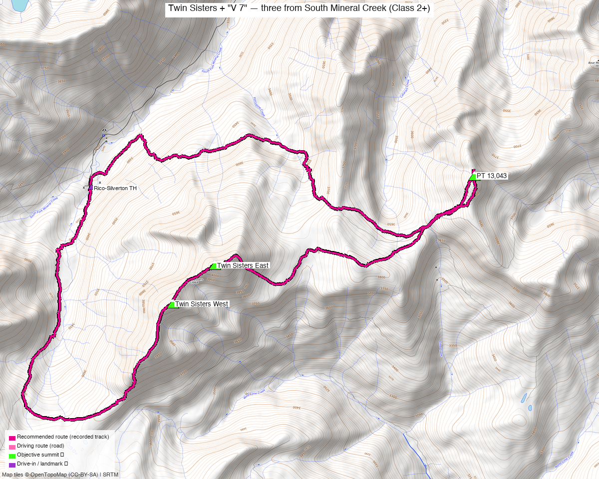
Note: the recommended route was distilled from 15 recorded GPS tracks of real trips (14ers.com · ListsofJohn · peakbagger) — all layered on the interactive CalTopo research map.
Peaks covered
Three unclimbed ranked 13ers in the San Juan Mountains, above South Mineral Creek west of Silverton — the Ice Lake / Ophir neighbourhood.
| Peak | Elev | Class | CO rank | Status |
|---|---|---|---|---|
| Twin Sisters East | 13,441' (LiDAR, +9) | 2+ | 295 | unclimbed |
| Twin Sisters West | 13,382' (LiDAR, +8) | 2+ | 335 | unclimbed |
| "V 7" | 13,043' | 2 | 610 | unclimbed |
San Juan & San Miguel counties, Ophir and Silverton quads — San Juan NF. No permits or fees.
\"V 7\" vs PT 13,043 — the name to search under
The sources disagree, and it matters when you go looking for beta:
- ListsofJohn: "V 7" (peak 780)
- 14ers.com: "V 7" (peak 10588)
- climb13ers: "V 7" [Previously UN 13042]
- peak_db (this site's database): PT 13,043 — the odd one out, and inconsistent with how it stores V 2 / V 4 / V 5 / V 9 under their V names
The V-number is the old Vermilion-group label: climb13ers notes the "V 7" designation appears in the 1932 San Juan Mountaineers' Climbers Guide. Search "V 7", not "PT 13,043".
peak_db's V 7 summit coordinate was 84 ft off
Relocated from the convergence of 8 recorded tracks (and 52 ft low). Corrected here and on the CalTopo map. The Twin Sisters markers checked out as-is.
Recommended route — all three from the Rico-Silverton TH ⭐
~12.0 mi · ~4,950 ft round trip, Class 2+, a loop from the Rico-Silverton TH (10,674'), taking the summits in the order Twin Sisters West → Twin Sisters East → "V 7".
This is the line 8 of the 15 recorded tracks use, and the shortest recording that reaches all three from a trailhead. Terrain is talus and tundra with minimal exposure; the difficulty is route choice among cliff bands, not climbing.
2.15 mi trimmed off the recorded track
The recording this route follows includes the party's own out-and-back to an unranked bump north of the ridge (tip ~37.79271, −107.76753) — 2.15 mi and ~300 ft of gain that reaches none of your three summits. It has been excised, which is why this route is 12.0 mi where the raw recording is 14.1 mi. If you want that bump, it's a side trip off the ridge; nothing in the day needs it.
Route sequence
- From the Rico-Silverton TH (10,674'), head up the South Fork of Mineral Creek.
- Climb to the southwest ridge and follow it to Twin Sisters West (13,382').
- Continue the short ridge to Twin Sisters East (13,441') — the two are only 0.44 mi apart and climb13ers is blunt that they "are usually climbed together, and it makes much sense to do so."
- Descend east and traverse the connecting ridge/basin ~2 mi to "V 7" (13,043').
- Return northwest to close the loop at the trailhead.
Talus and \"strategically placed cliffs\" — this is a routefinding day
climb13ers on the Twin Sisters: "A great deal of talus plus strategically placed cliffs render the Twin Sisters Peaks a Class 2+ hike that requires some careful route examination if done from the headwaters of the South Fork of Mineral Creek." Exposure is minimal — nothing here is exposed scrambling — but you can cliff yourself out. Carry the GPX and be willing to back off and re-read the terrain.
Their useful counterpoint: the V 7 side is the gentler way in. The approach they used for V 7 "offers perhaps an easier way to climb Twin Sisters than our initial route, keeping it closer to Class 2." If the direct South Fork line looks bad, the V 7 approach is the documented alternative — and it is on the way anyway.
The trail to V 7 is on almost no map
climb13ers, on the Porcupine Creek approach: the trail "does not show on the San Juan NF map or the Trails Illustrated #141 or the old USGS Ophir quad or the FS Topo series." It appears only on CalTopo's "MapBuilder Hybrid" layer, as a dotted red line. It also uses a section of the Hardrock 100 course. Useful waypoints from their description: the HR100 trail meets the road at 37.78897, −107.79712 (one-vehicle pullout just north), the creek crossing is at 37.78764, −107.79653, and the trail enters forest at 37.78640, −107.79614.
Splitting them up — the options, priced
You asked about splitting these into separate climbs. The measured answer is that combining wins outright — V 7 on its own from Molas Pass is longer than all three together:
| Option | Trailhead | Distance | Peaks | Notes |
|---|---|---|---|---|
| A — all three ⭐ | Rico-Silverton TH | 12.0 mi / 4,950 ft | 3 | the recommended route; needs 4WD up South Mineral |
| B — V 7 alone | 4WD spur, South Mineral | 8.8 mi / 2,565 ft | 1 | climb13ers' Porcupine Creek route |
| B — Twin Sisters alone | Molas Pass | 18.4 mi | 2 | recorded (trk_loj_8952); worse than doing all three |
| C — all three, no 4WD | Molas Pass (paved) | 18.2 mi | 3 | recorded (trk_14ers_2); +4.1 mi to skip the rough road |
| D — V 7 alone from the wrong side | Molas Pass | 13.7 mi | 1 | recorded; 13.7 mi for one peak vs 12.0 for three |
Read of that table: if you can drive the 4WD road, take Option A — three summits for the distance that one of them costs from Molas Pass. If you can't, Option C (Molas Pass, 18.2 mi, paved access) still gets all three in a day and is the sensible fallback. Splitting into two outings only makes sense if you want a short day: Option B's 8.8 mi V 7 is a genuinely easy half-day — Class 2, no exposure, "easy" routefinding.
Both trailheads are the same drive from home — ~8h 25m to Rico-Silverton (378 mi) and ~8h 23m
to Molas Pass (383 mi), and they are only 33 min / 13.5 mi apart by road (drive_matrix.py).
So a two-outing split off one basecamp costs nothing in driving; it just costs a day.
Getting there — Rico-Silverton TH (10,674')
| Drive from Boulder | ~8h 45m via Google Maps — via Silverton |
| Trailhead | 37.78037, −107.80293, 10,674' — OSM "Rico-Silverton Trailhead" (node/178051541), parking surface=ground, access=yes |
| Road | South Mineral Rd is smoothness=very_bad, tracktype=grade3. climb13ers: the first mile past the South Mineral CG "is passable for passenger cars carefully driven," then it gets "very rocky and slow" — "most any stock 4WD should have no problem. Higher clearance 2WD may be able to handle if driven slowly & carefully." |
| Without clearance | Start walking from the South Mineral Creek CG — climb13ers says that adds at least four miles. Or use Molas Pass (paved) instead. |
| Land | San Juan NF — no permits/fees. |
Gear & season
- Best window: July through September. ⚠️ Two swept tracks are winter/snow lines (Dec 2020 and May 2026) and are not the basis of this route — the December one is a ski line that happens to be the richest recording in the set, which is exactly why it was rejected.
- Terrain: Class 2+ — talus, tundra and cliff-band routefinding. Exposure minimal; no rope, axe or crampons in season.
- Early season is arguably easier: climb13ers notes "if climbed in the earlier season, snow fields may aid in avoiding some of the talus." Useful if you like snow travel; it also means more consequence if it's hard.
- Navigation: the crux skill. The Porcupine Creek trail is absent from every standard map (see above) — carry the GPX and the CalTopo MapBuilder Hybrid layer.
- Vehicle: the whole plan pivots on this. See Getting there.
- Storms: ~14 mi with a long ridge traverse, all above treeline in the middle — start early.
- Cell: assume none past Silverton; carry an InReach.
Other considerations
Nothing else unclimbed is close. Within 4 mi of Twin Sisters East, every other ranked peak is already yours: Rolling Mountain (2.2 mi), Beattie Pk (2.5), PT 13,302 (2.7), "V 9" (3.0), Vermilion Peak (3.0), Golden Horn (3.1), "V 2" (3.5), Pilot Knob A (3.6), "V 4" (3.7), US Grant Peak (3.8), "V 5" (3.9). This trio is what's left in the Ice Lake / Vermilion orbit, which is a good reason to take all three in one visit rather than coming back.
The Ice Lake Basin crowd. The Rico-Silverton TH sits beside one of the busiest trailheads in the San Juans (Ice Lake Basin). Expect a full parking area on summer weekends — but the crowds go to the lakes, not to these summits.
Trip reports & GPX (all three sources)
Sources confirmed logged in: 14ers.com ("letsgocu"), listsofjohn.com, peakbagger.com. All three peaks' libraries swept and deduped — 15 unique recorded tracks plus 111 mapped OSM trails, all layered on the research map.
- listsofjohn.com: Twin Sisters East 369 · Twin Sisters West 424 · "V 7" 780 — 8 unique tracks from 18 trip reports. gpx 8453 (2020-07) is the basis of the recommended route: all three summits, 14.1 mi as recorded (12.0 mi after trimming the party's non-objective out-and-back), starting 180 ft from the trailhead.
- 14ers.com: 10406 · 10431 · 10588 — 5 unique tracks. Each peak lists 4 GPX-library entries but there are only 5 distinct files between them, i.e. most parties take all three in one outing.
- peakbagger.com: 16673 · 10187 · 16216 — 2 unique GPS ascents; 2 more were byte-identical to LoJ copies, so they corroborate rather than add coverage. All three pids cross-checked against LoJ's links.
- climb13ers.com: Twin Sisters East · Twin Sisters West · "V 7" — source of the Class 2+ talus/cliffs assessment, the V 7 Porcupine Creek route (8.8 mi / 2,565'), the road description and the missing-from-all-maps trail note.
Sources checked: 14ers.com ✓ (logged in, "letsgocu") · listsofjohn.com ✓ (logged in) · peakbagger.com ✓ (logged in) · climb13ers.com ✓ (all three peaks)