PT 13,060 B (UN 13,067, 13,067', Elks) — Snowmass Creek North Ridge Route
Other climbers: Emily Sharpe — not yet · Shawn D Keil — not yet
At a glance — recommended day
14.3 mi · 4,735 ft gain · Class 3 · 1 peak · ~5.14 h drive
NOAA weather link: PT 13,060 B (UN 13,067) — Snowmass Creek North Ridge Weather
Drive from Boulder: ~5h 10m via Google Maps
CalTopo research map: https://caltopo.com/m/PEBRPUL
Researched: 2026-08-13
Status in Peak Checklist: unclimbed. PT 13,060 B (now officially 13,067' per LiDAR, CO rank #592) sits deep in the Snowmass Creek drainage of the Elk Mountains, due west of the sprawling Clark Peak massif. It is one of the least-visited ranked 13ers in the Elks — climb13ers has documented exactly one trip report for it (the 2013 first-ascent account by the Cooneys and Fred Askins) — and the route earns that reputation: genuinely difficult trail-finding, a loose 600' couloir, and a fine Class 3 summit ridge between you and the top.
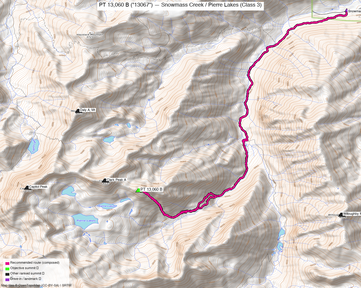
Note: the recommended route was distilled from 5 recorded GPS tracks of real trips (14ers.com · ListsofJohn · peakbagger) — all layered on the interactive CalTopo research map.
Peaks covered
PT 13,060 B — long listed at 13,060' but LiDAR adds 7 feet, making it 13,067' — sits at the east end of Clark Peak's summit ridge, separated from Clark by a col and connected by the brief "Wings of God" traverse. The Elks rank it #592 among Colorado peaks. It has a two-summited ridge: the western summit (closer to Clark) is the higher one; the eastern summit has a register but is demonstrably lower — the Cooneys confirmed this on the 2013 first ascent and added a register to the true top. Track convergence from three recordings places the western high point at 39.14954, -107.05193 — about 67 feet from the peak-db coordinate; the DEM-higher-point rule confirms the override.
| Peak | Elev | Class | CO rank | Status |
|---|---|---|---|---|
| PT 13,060 B (UN 13,067) | 13,067' | 3 | 592 | unclimbed |
Recommended route — the recommended line ⭐
14.3 mi · ~4,735 ft, Class 3 — a genuine out-and-back from Snowmass Creek TH; the geometry of the terrain and the approach make this the honest shape, not a compromise. The one alternative descent (south-facing couloir to Bear Creek / Pierre Lakes Basin) sheds 1,800' of talus in the wrong direction and the 2013 party — who tried it — described the resulting hike-out as the harder half of a 15-hour day and would not recommend it. The trail is pleasant for the first six miles; all the difficulty is in the upper terrain.
Route built from trk_pb_1.gpx (September 2024, 14.5 mi round trip), the most efficient recording in the collection and a near-exact match for climb13ers' 14.25 mi figure. trk_14ers_2.gpx (July 2025, 15.5 mi) confirms the same line. The two longer recordings — trk_14ers_1.gpx (23.3 mi) and trk_loj_16245.gpx (21.5 mi) — are consistent with parties that lost the Moon Lake trail section, the crux of route-finding on this approach.
Route sequence
-
Snowmass Creek TH (8,400') — the trail climbs east, passes through a stock gate (keep closed — cattle graze the Snowmass Falls Ranch land adjacent), gains ~200' and then contours south above the ranch boundary. Trail Forest Service #1975.
-
Snowmass Creek crossing (~1–1.5 mi in) — look for the unsigned junction and wade the creek where willows open into an approach field. This is the junction with West Snowmass Creek / Haystack Trail (#2187) — the trail heading across an open field into aspens on the far bank. The wade is straightforward except at high run-off.
-
West Snowmass Creek approach — the trail (#2187) crosses a diversion ditch and then climbs steadily and steeply through aspen and spruce. It is well-worn and easy to follow here. Pass through a cluster of evergreens and a good campsite area (~9,800'). Key navigation hazard: at the meadow around 10,400' the trail forks. The branch that drops toward the creek leads the wrong way into dense forest — take the high trail that cuts across the grassy, exposed hillside to the SW end of the meadow and picks up the unofficial Moon Lake trail climbing up the valley. This is the crux of route-finding on the entire day; Roach's description (referenced by climb13ers) is the authoritative guide to this junction.
-
Two notches on the NE ridge of UN 12,903 — from the upper valley, aim for a saddle on the NE ridge at the 12,000' contour, then contour south into a grassy bench below a second ridge. A second notch in this ridge — reached via a steep slope and narrowing couloir — brings you out into the upper Copper Creek basin. From the crest of this second notch you will have your first clear view of PT 13,060 B and the great couloir ahead.
-
Copper Creek upper basin traverse — descend into the basin, picking through talus and boulder fields. Sections of tundra provide relief. Traverse toward the base of the 600' north-facing couloir that lies just east of the summit block, maintaining as much elevation as possible.
-
The 600' couloir — the crux of the route. The couloir is very loose: rubble, mud, and unstable boulders with no stable footing. Climbing the snow in early season (ice axe recommended; crampons or microspikes for soft snow) is faster than the rocks but exposes you to falls; the rocks to the side are scarcely better. Move carefully and do not dislodge boulders onto the party below. The couloir tops out at a saddle.
-
400' Class 3 east ridge to the true summit — from the saddle, the east ridge scramble to the western (true) summit is genuinely enjoyable: large boulders, short drops and fractures, delightful Class 3 scrambling. The eastern summit arrives first and has a register, but stop there only briefly — the western summit is higher (confirmed on the 2013 FA), reached via the "Wings of God" traverse: a few minutes of exposed Class 3 moves across large rock blocks, including one that teeters as you swing across it. It is not as alarming as the name suggests, and takes only a few minutes. The Roach register lives at the western top.
-
Descent — reverse the east ridge and couloir. Take extra care descending the couloir in the afternoon sun when whatever snow softened to perfect crampon conditions in the morning has turned to slush, and loose rocks are most unstable. The south-facing couloir from the saddle is a theoretical loop option — it sheds 1,800' into the Bear Creek / Pierre Lakes drainage — but the 2013 party's account of the hike-out (faint trail, dense vegetation, talus, crossing Snowmass Creek well below the TH) is not encouraging.
Getting there — Snowmass Creek TH (8,400')
| Drive from Boulder | ~5h 10m via Google Maps · 221 mi |
| Trailhead | Snowmass Creek TH, 39.20009, -106.99397, 8,400' |
| Road | From CO-82 between Basalt and Aspen, turn south at the lighted intersection at Snowmass (~4 mi south of Basalt). Drive ~2 mi to a Y-intersection — take the left fork (east/south) on N690. Paved 4–5 mi, then good-quality graded dirt another ~4 mi to a crossing of Snowmass Creek; beyond the creek the road climbs to one more intersection — turn right (south) to the TH parking area a few hundred yards further. East Snowmass Creek TH is passed just before the main lot. Passenger car accessible. |
| Parking | End of road; fills on summer weekends. Overflow parking along the road in. A locked gate at the ranch boundary immediately past the TH marks the end of public access. |
| Camping | Car-camping near the TH is possible when the lot is not full. No vault toilets — ReStops are provided at the register, free of charge. Camping is also possible inside the drainage (good sites around 10,400'). |
Gear & season
- Best window: July–September. Recorded ascents span July–September 2024–2025; those correspond to reasonable conditions in the couloir. Earlier season carries more snow — the 2013 party encountered very soft snow in the couloir and rated the rock beneath it even worse. Bring an ice axe if going before mid-July; microspikes or crampons if the couloir looks snowy.
- Terrain/gear: trail for the approach, then off-trail talus, boulder fields, and a loose couloir. Stiff approach shoes or light boots; trekking poles are useful on the steep trail section. A helmet is worth serious consideration for the couloir — the rock is very loose and described as "watch for falling mountains" terrain. The 400' east ridge is stable Class 3 scrambling by contrast.
- Route-finding: rated difficult (climb13ers). The Moon Lake trail junction at ~10,400' is the most dangerous point to navigate because losing it adds miles and hours (the longer recordings in the collection reflect this). Carry Roach's Hiking Colorado's Thirteenth Highest Peaks or download the CalTopo research map offline before the drive.
- Storms: the approach valley is sheltered, but the upper couloir and ridge sit above treeline with no escape from afternoon lightning. Start early enough to be on the descent from the summit by noon; a 4:00–5:00 AM TH start is not excessive for a 14+ mi day with this much route complexity.
- Water: Snowmass Creek, West Snowmass Creek, and side streams provide water through most of the approach. The couloir and summit ridge are dry.
Other considerations
- Far from home — plan an overnight. The drive is ~5h 10m from Boulder, making a same-day car-to-car pure day-trip brutal. The TH has car-camping when not crowded; the meadow camp area at ~10,400' inside the drainage is even better (good flat ground, stream water, views back down the valley). A Friday-evening drive and TH camp, summit Saturday, home Saturday evening is the right structure for this one.
- Neighboring peaks share this TH but this is a solo report. Willoughby Mountain and PT 13,255 are also accessed via Snowmass Creek TH per climb13ers' trailhead page. Kyle's grouping call (recorded in deviations.yml, 2026-08-12) settles this as a solo report — the approaches do not link into a reasonable single-day combination. The other tempting Elks neighbors (Daly A via Capitol Creek; Siberia Peak via Lead King Basin) approach from entirely different drainages and share nothing with Snowmass Creek.
- The two summits — visit both. The eastern summit with the old, waterlogged register is lower; the true high point is the western summit with Roach's register. The "Wings of God" traverse takes only a few minutes and is well worth it — skip it and you have not stood on the official summit.
- UN 12,903 as a side-trip: the first notch on the NE ridge of UN 12,903 passes close enough that a side-trip to its summit (Class 2 from the saddle) is feasible at modest extra cost. It sits just off the route and the Cooneys noted they chose not to bag it — something worth considering if the day is going well.
Trip reports & GPX (all three sources)
Sources confirmed checked: 14ers.com (peak 10131) · listsofjohn.com (peak 760) · peakbagger.com (peak 84897 — verified cross-site id against LoJ's "Unnamed 13,067" cross-link). All swept fresh for this build and layered on the research map.
-
14ers.com: 2 track(s) harvested (trk_14ers_1.gpx 23.3 mi and trk_14ers_2.gpx 15.5 mi). trk_14ers_1 is the long version (~2024-09) consistent with parties that lost the Moon Lake trail. trk_14ers_2 (2025-07, 15.5 mi) is the cleaner, more direct recording from a party that navigated the upper trail more efficiently.
-
listsofjohn.com: 2 track(s) harvested. trk_loj_16245.gpx (21.5 mi) is a valid summer recording — long, again consistent with navigation difficulty in the upper approach. trk_loj_2794.gpx (19.2 mi) rejected — DRAWN LINE with no timestamps; excluded from routing and track counts.
-
peakbagger.com: 2 track(s) harvested. trk_pb_1.gpx (14.5 mi, 2024-09) — the route-building track and the most efficient recording in the collection, closely matching climb13ers' 14.25 mi RT figure. trk_pb_2.gpx (6.4 mi) rejected — starts at 11,165' (spur from near-summit, covering 0/1 objectives), one-way partial only.
The four recorded trips (rejecting the drawn line and the partial) span the range 14.5–23.3 mi round trip, all from the same TH. The spread directly reflects the navigation challenge at the Moon Lake junction: parties who find the unofficial trail at ~10,400' complete the climb in 14–15.5 miles; parties who miss it and scramble cross-country log 21+ miles. The CalTopo research map, the Roach description, and studying the drainage before leaving the trailhead are the best preparation.
Sources checked: 14ers.com ✓ · listsofjohn.com ✓ · peakbagger.com ✓ · climb13ers.com ✓ (class + route character, URL above)