Precarious + "Cassi" + "Golden Tops" — the Rustler Gulch trio (Class 4)
Other climbers: Emily Sharpe — not yet · Shawn D Keil — 2 of 3 (Cassi Pk, PT 13,260 A)
At a glance — recommended day
10.9 mi · 4,283 ft gain · Class 4 · 3 peaks · ~7.3 h drive
NOAA weather link: Rustler Gulch Weather
CalTopo research map: https://caltopo.com/m/BTS1Q96
Researched: 2026-08-03
Status in Peak Checklist: all three unclimbed.
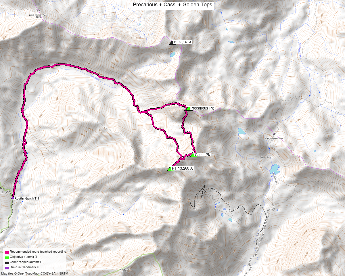
Note: the recommended route was distilled from 11 recorded GPS tracks of real trips (14ers.com · ListsofJohn) — all layered on the interactive CalTopo research map.
Peaks covered
| Peak | Elev | Class | CO rank | Rise |
|---|---|---|---|---|
| Precarious Peak | 13,378' (LiDAR) | 3 | 340 | 657' |
| "Golden Tops" (PT 13,260 A) | 13,262' | 2 | 432 | — |
| "Cassi Peak" | 13,242' | 2 | 447 | — |
Gunnison County, Maroon Bells quad — the head of Rustler Gulch, east of Schofield Pass. All three sit within 0.9 miles of each other, which is why they are one day.
The party who has written the best beta on them calls them "the Precarious group, or Precariousness Trio", and is blunt about the rock:
"They epitomize all that is the worst of the Elk Range: loose, horrid rock. Best done in spring snow." — 14ers TR 23303
Summit note — Precarious moved. peak_db's coordinate sat 180 ft southwest of the crest. listsofjohn's LiDAR coordinate is 39.01690, −106.96208, identical to where 7 recorded tracks converge, and ned10m puts the two within 5 ft of each other — so the convergence is the real high point, not a downhill dwell spot. The map marker uses the corrected position.
The recommended route — 10.9 mi / 4,283 ft
From the upper Rustler Gulch TH (10,239'), composed per leg from four recordings:
| Leg | Distance | On trail | Source |
|---|---|---|---|
| TH → Precarious Peak | 4.63 mi | 72% | trk_14ers_2 |
| Precarious → Cassi Peak | 0.91 mi | — | trk_14ers_3 |
| Cassi → Golden Tops | 0.39 mi | — | trk_loj_16183 |
| Golden Tops → TH | 4.94 mi | 66% | trk_14ers_5 |
The direction is deliberate, and it is not the one the optimiser picked. The route composer scores distance, gain and on-trail fraction — it has no notion of difficulty. With the two directions within 0.12 mi of each other it chose the reverse on what is effectively noise. The order here is pinned to the beta instead. Marmot72, who did all three, is explicit: "Definitely this route goes better Precarious to Golden Tops rather than the reverse." The approach up Rustler Gulch is on a "strong, well-defined trail" for the first several miles; everything above is the reason these peaks are seldom climbed.
The Precarious → Cassi link was, until recently, undocumented. In the comments on that report another climber notes: "I've not heard of anyone linking Precarious and Cassi directly before… most reports backtrack the ascent of Precarious and go up Cassi another way." Marmot72's answer:
"Honestly, yes… it was pretty easy. Class 2 and not treacherous; the class 3 was getting up the weakness on the cliff band — it was short, easy 3, on rock that was not too covered by loose stuff."
That connection is what makes this a 10.9 mi trio instead of three separate re-ascents, and it is
trk_14ers_3 carrying leg 2 here.
The north ridge of Precarious — three notches, and the guidebook under-grades it
The ridge to Precarious from the north holds three notches. Derek Wolfe's Elk Range Mountains calls the route Class 3. The most recent party to climb it disagrees:
"I thought this route was better described as class four. Not sustained class four, but I thought that each of the two first notches involved a class four move to get moving back upward."
Combined with the rock quality — "all of the rocks were suspect", moved at a "guarded pace" rather than a "jaunty pace" — the headline here takes Class 4.
There is a way to avoid it entirely, and it is worth considering. Marmot72's own recommendation, given after the fact:
"The route would go in reverse, with a return back south from the Precarious summit, and that way you avoid the difficulty of the north ridge."
Climb Cassi first, take the easy Class 3 cliff-band weakness up Precarious's south side, and reverse. The cost: "this means going both up and down the long tedious rock glacier beneath Cassi" — and that rock glacier is the other thing everybody complains about. You are trading a Class 4 move for an hour of boulder-hopping. Reasonable people pick either.
Getting there — Rustler Gulch
| Drive from Boulder | ~7h 20m via Google Maps (~259 mi) — the longest drive on this site. Crested Butte, then Gothic Road / Schofield Pass Road. |
| Trailhead | Upper Rustler Gulch TH, 38.99924, −107.00306, 10,239' — past the creek crossing on Rustler Gulch Road 317.3C. |
| Road | A "regular SUV" reportedly makes the upper trailhead; the road is surface=dirt, smoothness=very_bad, tracktype=grade3. If you stop at the road junction (9,718') instead, it costs about 1.5 mi round trip and 300 ft — a small penalty, so do not push a marginal vehicle. |
| Land | Gunnison NF. The access sweep found no restrictions near the route; the private parcels it returned are the Rocky Mountain Biological Laboratory at Gothic and the Aspen ski areas, both far off. |
Gear & season
- Best window: this is the unusual case where the beta prefers spring snow. Both first-hand reports say the same thing — "best done in spring snow" and "if you have snow climbing skills… wait until the spring season for these two 13ers. But then access becomes an issue. There has to be a 'sweet spot.'" Snow covers the rock glacier and stabilises the choss; the catch is that Schofield Pass Road has to be open. Late June is the compromise.
- The boulders are the hidden cost. JQDivide: "I haven't walked on this many boulders since doing the Moon Lake Approach to Capitol. Such an energy suck. It's like hiking twice the distance." Marmot72 expected 2 hours back to the car and took 3. Budget on time, not mileage — 10.9 mi here is not a 10.9 mi day.
- Helmet: yes. This is the loosest rock in a range known for loose rock.
- Poles: "Golden Tops: it's a loose pile of #$%^&. Don't put away your trekking poles."*
- Route-finding above 11,790: there is a built, cairned trail on the right side of the large boulder at ~11,790 that most parties miss by going left; it switchbacks up to a cairn at 12,100 and continues to about 12,200.
Other considerations
Golden Tops has two summits, and the register is on the lower one. Marmot72 found the register on the eastern top but noted the western "certainly appeared taller, both from this vantage and also from my approach in the morning." Our own data agrees with him and not with the register: peak_db's marker sits on the western top inside the closed summit contour, while the 7-track convergence — where parties actually stop — is 114 ft northeast and reads 39 ft lower on ned10m. Tag both tops; they are a two-minute walk apart and it costs nothing to be sure.
Belleview is the neighbour, and it is the better climb. Belleview Mountain
sits at the head of the same drainage system, 2.7 mi from Precarious — one recorded party
(trk_loj_16183, josephnephi) took Belleview, all three of these, and two already-climbed peaks
in a single 17.7 mi push. JQDivide, mid-boulder-field, was blunter: "13er Belleview in the
background, which is a much better climb." Belleview goes from the East Fork TH, a different
trailhead, so it is a separate report — but if you want a reason to be in this area twice, that
is it.
The long way in. One recorded track reaches Precarious from Lower Judd Falls at Gothic (15.1 mi round trip) rather than Rustler Gulch, and another links it into a 47.6 mi traverse from Capitol Creek. Neither is a reason to skip the short approach.
Trip reports & GPX (all three sources)
All three sources swept across all three objective peaks and deduped, plus the mapped OSM trail network — all layered on the research map.
- 14ers.com: peaks 10108, 10121 and 10118 — 7 GPX-library tracks. None of the three has a formal route description; all the beta above is from trip reports.
- listsofjohn.com: peaks 414 (Class 3), 560 (Class 2) and 535 (Class 2) — 4 tracks from 13 trip reports. LoJ cross-verified all three peakbagger ids: 84916 / 16273 / 84909.
- peakbagger.com: peaks 84916, 16273 and 84909 — 3 ascent tracks with GPS, all three duplicates of another source.
Sources checked: 14ers.com ✓ · listsofjohn.com ✓ · peakbagger.com ✓