PT 13,179, PT 13,076 & PT 13,003
Other climbers: Emily Sharpe — not yet · Shawn D Keil — 1 of 3 (PT 13,076)
At a glance — recommended day
11.3 mi · 3,961 ft gain · Class 2 · 3 peaks · ~8.83 h drive
NOAA weather link: PT 13,179, PT 13,076 & PT 13,003 Weather
Drive from Boulder: 8h 50m via Google Maps
CalTopo research map: https://caltopo.com/m/VD8HVG1
Researched: 2026-08-30
Status in Peak Checklist: unclimbed. All three are unnamed Colorado 13ers in the 497–635 rank band — tundra Class 2 summits that pack into a single day when combined from the Silverton approach via Minnie Gulch. A logical anchor for a Silverton multi-day.
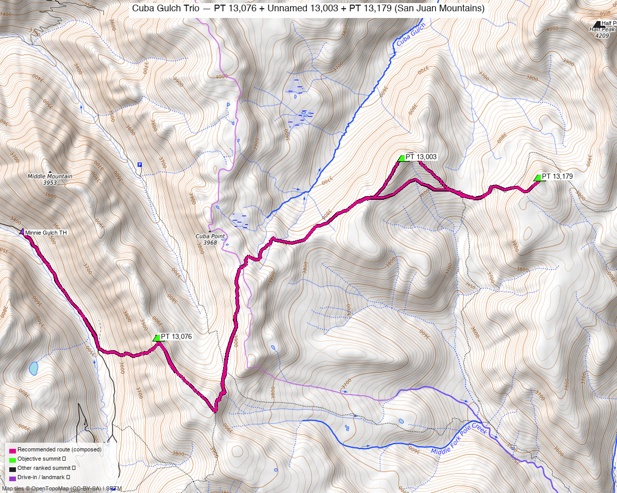
Note: the recommended route was distilled from 8 recorded GPS tracks of real trips (14ers.com · ListsofJohn · peakbagger) — all layered on the interactive CalTopo research map.
Peaks covered
All three summits sit in the San Juan National Forest in the upper Pole Creek / Cuba Gulch headwaters southwest of Lake City and south of Silverton. No wilderness permit or trailhead fee is required. PT 13,003 and PT 13,179 are the Cuba Gulch pair — they share a col and are frequently listed as a two-peak combination from the Lake City approach. PT 13,076 lies 2.3 miles southwest in the upper Maggie Gulch / Minnie Gulch headwaters. Reaching all three from a single trailhead requires the Silverton-side approach: the Minnie Gulch TH is the only start that connects all three without crossing ranked non-objective summits.
| Peak | Elev | Class | CO rank | Status |
|---|---|---|---|---|
| PT 13,179 | 13,179' | 2 | 497 | unclimbed |
| PT 13,076 | 13,076' | 2 | 589 | unclimbed |
| PT 13,003 | 13,003' | 1 | 635 | unclimbed |
Recommended route — the recommended line ⭐
11.3 mi · ~3,961 ft, Class 2 — A tundra-ridge loop connecting the two Cuba Gulch summits and the Minnie Gulch headwaters peak from a single high trailhead. The main route-finding challenge is a broad willow field in the Cuba Gulch headwaters (roughly 11,400–12,000 ft) where elk game trails crisscross and obscure the line; beyond that the terrain is open tundra with short talus sections, a brief cairned bypass around PT 13,179's north cliff band, and no exposure anywhere on the route. The Upper Minnie Gulch Trail provides trail access to within ~0.3 miles of PT 13,076's summit.
Route sequence
- Minnie Gulch TH (11,600') — Head northeast from the road end, contouring up toward the Cuba Gulch headwaters drainage.
- Cuba Gulch headwaters willow zone (~11,400–12,000') — The route crosses an extensive willow field; elk trails multiply here and add to the navigation puzzle. Aim for the broad col east of PT 13,003, staying patient with routefinding.
- PT 13,003 (13,003', CO rank 635) — Short walk up the SE ridge from the col. Almost entirely tundra, no exposure; one of the friendliest approaches on the list (climb13ers: "almost all tundra terrain").
- Col between PT 13,003 and PT 13,179 (~12,800') — Brief ridge traverse east.
- PT 13,179 (13,179', CO rank 497) — A cliff band guards the direct north approach; follow shepherd-built cairns around the west and south side to a tundra bench, then top out. Steepness moderate (climb13ers: "A Satisfying Workout"), no exposure.
- Return to col (~12,800') — Retrace the ridge west to the col between the Cuba Gulch peaks.
- Southwest traverse to Minnie Gulch (~11,600') — Drop back through the willows and southwest to regain the Upper Minnie Gulch Trail.
- PT 13,076 (13,076', CO rank 589) — South on the trail, then a direct ascent of the west slope on tundra and talus. Stiff climb but easy routefinding; no exposure (climb13ers: "Stiff uphill climb", easy routefinding).
- Return to TH (11,600') — North on the Upper Minnie Gulch Trail to the road end.
Getting there — Minnie Gulch TH (11,600')
| Drive from Boulder | 8h 50m via Google Maps |
| Trailhead | Minnie Gulch TH, 37.84755, -107.53213, 11,600' |
| Road | County Road 24 (Minnie Gulch Road) off US 550 north of Silverton: grade-3 gravel, high-clearance 4WD recommended. Road ends at the trailhead. A lower-clearance start near the county road junction (~9,800') adds ~3.5 mi each way on the road. |
| Land | San Juan National Forest — no permit or fee required. |
Gear & season
- Best window: July through September. trk_14ers_4 (July 2025) confirms full summer access to the Minnie Gulch upper TH and all three summits. June is shoulder season — late snow lingers in the Cuba Gulch headwaters willow zone.
- Terrain & gear: All tundra and talus; no technical gear required. Trekking poles help in the willows and on the descent from PT 13,076's west slope. The Upper Minnie Gulch Trail covers most of the PT 13,076 leg.
- Afternoon storms: Standard San Juan summer convection — aim for all three summits before noon. The Minnie Gulch drainage offers no above-treeline shelter, so a pre-dawn start from Silverton keeps the margins comfortable.
- Cell coverage: Minimal to none in the Minnie Gulch drainage. Plan accordingly and let someone know your itinerary.
Other considerations
Silverton multi-day. At nearly 9 hours from Boulder, this is a dedicated Silverton trip. The Cuba Gulch Trio does not share trailhead infrastructure with any adjacent day — the Minnie Gulch TH is specific to this group. Adjacent days can pull from the Silverton cluster without conflict: Kendall Mountain, Mountaineer Peak, Bonita Peak, and the PT 13,117/13,073 group each have separate reports already; Tower Mountain and Dome Mountain A lack reports and would pair well without TH overlap. Little Giant Peak (Arrastra Gulch) and Campbell Creek Peak (Grizzly Gulch) have their own reports with incompatible drainages.
Cuba Gulch TH alternative. The canonical two-peak (PT 13,003 + PT 13,179) approach from Lake City uses the Cuba Gulch TH (10,715', 4x4-only, via HWY 149 and Cottonwood Creek Road, ~4h from Boulder). If PT 13,076 is not on the day's list, that Lake City approach is shorter and the evidence is strong. The all-three linkup requires the Silverton side.
Trip reports & GPX (all three sources)
Sources confirmed logged in: 14ers.com ("Basin"), listsofjohn.com ("letsgocu"), peakbagger.com ("Kyle Knutson"). All three swept fresh for this build, plus the mapped OSM trails in the bbox — all layered on the research map.
-
14ers.com: 8 track(s) harvested. Activity on all three peak pages; most volume on PT 13,003 and PT 13,179 via the Cuba Gulch corridor. The single clean summer all-three recording (trk_14ers_4, July 2025) became the recipe candidate.
-
listsofjohn.com: 6 track(s) harvested (+6 duplicate(s) of another source). LoJ rates PT 13,003 at Class 1+, PT 13,179 and PT 13,076 both at Class 2; the harder estimate (Class 2) is the headline.
-
peakbagger.com: 6 track(s) harvested (+9 duplicate(s) of another source). Peakbagger pages confirmed for all three summits (pb ids 39878, 15336, 39877).
Sources checked: 14ers.com ✓ (logged in, "Basin") · listsofjohn.com ✓ (logged in, "letsgocu") · peakbagger.com ✓ (logged in, "Kyle Knutson")