Rio Grande Pyramid Three — PT 13,290 + PT 13,274 + PT 13,022 (Weminuche)
At a glance — recommended day
24.8 mi · 5,984 ft gain · Class 2–4 · 3 peaks · ~5.75 h drive
NOAA weather link: Rio Grande Pyramid Three Weather
Drive from Boulder: ~5h 45m via Google Maps
CalTopo research map: https://caltopo.com/m/H1V1M10
Researched: 2026-06-15
Status in Peak Checklist: all three unclimbed. (Rio Grande Pyramid, Window Pk + Ute Ridge already done.)
The three red peaks around Rio Grande Pyramid in the Weminuche Wilderness — deep, remote, and a long way in. Two are easy Class 2; PT 13,022 has a Class 3–4 exposed crux.
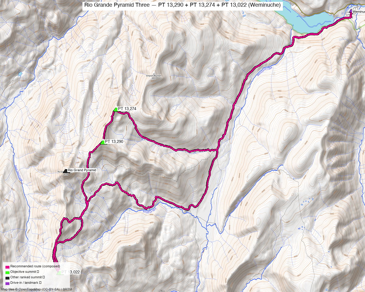
Note: the recommended route was distilled from 10 recorded GPS tracks of real trips (14ers.com · ListsofJohn) — all layered on the interactive CalTopo research map.
Other climbers: Emily Sharpe — not yet · Shawn D Keil — ✓ all
Peaks covered
| PT 13,290 ("Fools Pyramid") | PT 13,274 | PT 13,022 | |
|---|---|---|---|
| Elevation | 13,290' | 13,274' | 13,022' |
| Lat / Lon | 37.6876, −107.3750 | 37.6966, −107.3690 | 37.6517, −107.3953 |
| Class | 2 | 2 | 3–4 (exposed summit block) |
| CO Rank | 409 | 421 | 624 |
| Also known as | formerly UN 13,278 | formerly UN 13,261 | formerly UN 13,017 |
| Position | 1.1 mi NE of RGP | 1.7 mi NE of RGP | 1.9 mi SW of RGP |
| 14ers.com | 10473 | 10479 | 10600 |
| LoJ | 517 | 532 | 804 |
| peakbagger | 14836 | 16165 | 39890 |
| Peak DB id | 517 | 532 | 804 |
PT 13,290 + PT 13,274 are a ridge-connected Class 2 pair NE of Rio Grande Pyramid; PT 13,022 sits SW across the basin and is the hard one.
The single push — Weminuche Trail TH loop ⭐
A real recorded loop through all three, from the Weminuche Trail TH — ~24.8 mi · ~5,980 ft, the honest full-approach day. It's a big day: the Weminuche approach is long and deep. A party did the whole RGP group (these three + Rio Grande Pyramid) in one ~30 mi / ~9,800′ day (LoJ TR 1934), noting "some might say stupid" to do it as a day trip. Most people backpack (see Other considerations).
| Peaks | PT 13,290 + PT 13,274 + PT 13,022 |
| Class | 2, but PT 13,022 is the crux: "a fairly complicated and exposed 3rd–4th class scramble on teetering blocks" on the final ~200′. Helmet; the other two are straightforward Class 2. |
| Trailhead | Weminuche Trail TH (Thirtymile, Rio Grande Reservoir), ~9,300' — 2WD |
Route sequence
- From the Weminuche Trail TH at Rio Grande Reservoir, hike the long Weminuche Creek trail in toward Weminuche Pass / the Rio Grande Pyramid basin.
- PT 13,022 first (SW side) — easy until the exposed Class 3–4 summit block (teetering blocks, ~200′).
- Cross to the NE pair: PT 13,290 ("Fools Pyramid") → PT 13,274 — ridge-connected Class 2.
- Long hike back out to the TH.
Getting there — Weminuche Trail TH
| Drive from Boulder | ~5h 45m via Google Maps — via Creede / South Fork to the Rio Grande Reservoir (FR 520), then the Weminuche Trail TH. ("~5 hrs from Denver" per TR.) |
| Trailhead | Weminuche Trail TH (Thirtymile), ~37.7233, −107.259, ~9,300' — 2WD (passenger car). |
| Land | Weminuche Wilderness (Rio Grande NF) — no permits/fees, foot/stock only; dispersed/backpack camping allowed. |
Gear & season
- Best window: July–September — deep, high Weminuche; long approach holds snow.
- Terrain: mostly Class 2 tundra/talus; the PT 13,022 summit block is exposed Class 3–4 on loose, teetering rock — the one place to be careful.
- Storms: you're a long way from the car — start very early or (better) camp high.
- Cell: dead, deep wilderness — InReach essential.
Other considerations
Strongly consider a backpack ⛺ — this is classic backpack country. A short, easy pack-in — ~5 mi / ~1,325′ to a base camp near Weminuche Pass / the meadows — sets you up for all the Rio Grande Pyramid 13ers (these three + RGP + Window) on short summit days, instead of the ~25-mile full-approach push. Given the distance, a 2-night backpack is still a great way to clean up these three.
Trip reports & GPX (all sources)
Sources confirmed logged in: 14ers.com ("letsgocu"), listsofjohn.com, peakbagger.com (Kyle Knutson). 8 14ers-library tracks (3 covering all three peaks) + Kyle's CalTopo are layered; recommended loop magenta. peakbagger has no downloadable ascent GPX for these.
listsofjohn.com (logged in)
Four TRs cover all three: 24937, 7484, 1934 (the ~30 mi RGP-group day), 1560.
14ers.com GPX library (logged in, "letsgocu")
Multiple recorded tracks doing the NE pair and all three — layered.
peakbagger.com (logged in, "Kyle Knutson")
Pages verified for all three; ownership = Weminuche Wilderness (Rio Grande NF).
climb13ers.com
Fools Pyramid / PT 13,290 (SW Ridge) · PT 13,274 (SSW Ridge) · PT 13,022 (SE Ridge) — the last flags the exposed Class 3–4 summit block. Also Wild Wanderer — RGP 13ers basecamp (backpack beta).
Sources checked: 14ers.com ✓ (logged in, "letsgocu") · listsofjohn.com ✓ · peakbagger.com ✓ (logged in, "Kyle Knutson") · climb13ers.com ✓ · Kyle's CalTopo ✓