Pigeon, Turret, Monitor & Animas — Needleton train backpack
Other climbers: Kyle Knutson — ✓ all · Shawn D Keil — 2 of 4 (Pigeon Peak, Turret Peak A)
At a glance — 4-day trip
4 peaks · ~8.37 h drive
- Day 1 (Pack-in (Needleton to Ruby Creek camp)): 5.2 mi · 3,640 ft gain · Class 1
- Day 2 (Pigeon + Turret): 4.9 mi · 4,572 ft gain · Class 4 · 2 peaks
- Day 3 (Monitor + Animas): 3.9 mi · 3,368 ft gain · Class 4 · 2 peaks
- Day 4 (Pack-out (Ruby Creek camp to Needleton)): 5.2 mi · 3,640 ft gain · Class 1
NOAA weather link: Pigeon, Turret, Monitor & Animas — Needleton train backpack Weather
CalTopo research map: https://caltopo.com/m/0DFSN7F
Researched: 2026-08-25
Status in Peak Checklist: all four unclimbed — the Ruby Creek group is one of the Weminuche Wilderness' most committing objectives: train-only access, a serious alpine hike to basecamp, and two days of Class 4 scrambling from the same high camp. Pigeon, Turret, Monitor, and Animas together represent a meaningful first entry in Kyle's Weminuche log.
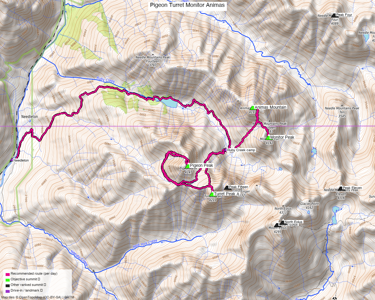
Note: the recommended route was distilled from 18 recorded GPS tracks of real trips (14ers.com · ListsofJohn · peakbagger) — all layered on the interactive CalTopo research map.
Peaks covered
Four ranked 13ers deep in the Weminuche Wilderness (San Juan National Forest), all accessed from the upper Ruby Creek drainage — a pocket of dramatic alpine terrain reachable only by the Durango & Silverton Narrow Gauge Railroad. No permits or entry fees; standard Wilderness rules apply (group size ≤ 15, camp ≥ 100 ft from water and trails, pack out all waste). Pigeon (13,977') soars a full mile above the Animas canyon in a series of striking rock towers; Turret (13,837') is its immediate neighbor and the easiest of the group; Monitor (13,707') and Animas Mountain (13,789') form a separate sub-group to the northeast of the Ruby Creek camp. The trip's headline class is 4 — both summit days carry Class 4 moves (Pigeon's 15-ft chimney crux and Monitor's three-couloir crossing). climb13ers groups all four peaks under the "Ruby Creek summits" label on the same basin map.
| Peak | Elev | Class | CO rank | Day | Status |
|---|---|---|---|---|---|
| Pigeon Peak | 13,977' | 3 | 58 | 2 | unclimbed |
| Turret Peak A | 13,837' | 2 | 92 | 2 | unclimbed |
| Monitor Peak | 13,707' | 4 | 143 | 3 | unclimbed |
| Animas Mountain | 13,789' | 4 | 113 | 3 | unclimbed |
Day 1 — Pack-in (Needleton to Ruby Creek camp)
5.2 mi · ~3,640 ft, Class 1 — the Ruby Creek Trail from the Needleton footbridge to the upper-basin basecamp. Not a casual walk-in: climb13ers warns of very steep sections requiring tree-assist, willow bushwhack near Ruby Lake, and confusing junctions — 5.2 mi gaining nearly 3,400' to the meadow camp at 11,624'. Three recorded approach tracks (trk_14ers_2, trk_14ers_13, and the approach segment of trk_14ers_3) confirm the corridor; the trail follows Ruby Creek throughout. Allow 4–5 hours with a pack.
Day 1 sequence
- Durango D&SNG depot (~6,512') — board the morning train; ~3–3.5 h to the Needleton flag stop (book a seat and request the whistle stop in advance).
- Needleton (8,235') — exit the train, cross the Animas River footbridge.
- Pick up the Ruby Creek Trail heading east up the canyon.
- Steep sustained ascent — very steep sections; tree-assist required in places; watch for willow bushwhack near Ruby Lake.
- Navigate junctions carefully; stay on Ruby Creek drainage (not Needle Creek or Chicago Basin forks).
- Ruby Creek camp (11,624') — upper meadow basecamp; set up for two summit days.
Day 2 — Pigeon + Turret
4.9 mi · ~4,572 ft, Class 4 — from camp, head south and southwest toward Pigeon Peak's SW basin: steep tundra couloir, boulder talus, stacked granite blocks. The summit block is broken granite with large cracks — "much like Sunlight Peak" (climb13ers). Class 4 crux: a 15-ft near-vertical chimney-like slot (documented by Roach); the northern summit is the true high point. Descend back toward the Pigeon-Turret saddle, then ascend ESE up Turret's NW slopes through broken rock, talus, and tundra — the only true walk-up of the Ruby Creek group (Class 2+, climb13ers). Return to camp on the same line. Ice axe recommended early season for the Pigeon couloir; helmet strongly recommended throughout. No rope needed per all sources; confident scrambling required. No summer closed-loop recording from camp covers this day — the composed line is synthesized from available tracks including the corridor evidence from trk_loj_16158 (outbound direction Pigeon→Turret, confirmed).
Day 2 sequence
- Ruby Creek camp (11,624') — depart south/southwest toward Pigeon's SW basin.
- Gain the basin via steep tundra couloir (ice axe if early season).
- Ascend boulder talus and stacked granite blocks up Pigeon's upper summit pyramid.
- Class 4 crux: 15-ft near-vertical chimney-like slot.
- Pigeon Peak (13,977', CO rank #58) — northern summit is the true high point. Matterhorn-shaped; soars a full mile above the Animas River.
- Descend to the Pigeon-Turret saddle (retrace the approach).
- Ascend ESE on Turret's NW slopes — broken rock, talus, tundra (Class 2+, ~300' gain from the saddle).
- Turret Peak A (13,837', CO rank #92) — the group's gentlest summit.
- Descend back to Ruby Creek camp (11,624').
Day 3 — Monitor + Animas
3.9 mi · ~3,368 ft, Class 4 — from camp, head northeast ascending a steep grassy slope ~800' toward Peak Thirteen, then follow the "unmistakable gash" — a 6-ft-wide ledge/ramp across Peak Thirteen's SW face — to the Thirteen-Monitor saddle. Class 4 crux band: cross three steep couloirs on Monitor's west side; at each rock rib between couloirs, expect a short (~10 ft) near-vertical move on generally solid granite — "We did not require rope" (climb13ers). Class 3 ridge scramble above the couloir band to Monitor's summit. For Animas: descend Monitor's north ridge back through the couloirs to the Thirteen-Monitor saddle, traverse Peak Thirteen's south ridge (exposed sub-summit), drop to the 13,500' saddle, and ascend the East Ridge couloir; the couloir exit — climbing right over blocks and ledges — is the crux (Class 3 to most, Class 4 by some accounts; peak_db lists Class 4). climb13ers calls the Monitor–Peak 13–Animas sequence "a very entertaining day." The definitive recording is trk_14ers_7 (2022-09, closed loop from Ruby Creek camp, 3.9 mi, covering Monitor→Animas and returning to camp — the only summer from-camp loop over both objectives).
Day 3 sequence
- Ruby Creek camp (11,624') — depart northeast.
- Ascend steep grassy slope ~800' toward Peak Thirteen.
- Follow the "unmistakable gash" — 6-ft-wide ledge/ramp across Peak Thirteen's SW face.
- Reach the Thirteen-Monitor saddle.
- Cross three steep couloirs on Monitor's west side — Class 4 rock ribs (~10 ft near-vertical, solid granite, no rope needed).
- Class 3 ridge scramble above the couloir band.
- Monitor Peak (13,707', CO rank #143) — summit.
- Descend Monitor's north ridge back through the couloir band to the Thirteen-Monitor saddle.
- Traverse Peak Thirteen's south ridge (exposed sub-summit).
- Descend to the 13,500' saddle.
- Ascend the steep East Ridge couloir to Animas Mountain (13,789', CO rank #113) — exit crux (Class 3–4, blocks and ledges).
- Descend couloir and traverse back to Ruby Creek camp (11,624').
Day 4 — Pack-out (Ruby Creek camp to Needleton)
5.2 mi · ~3,640 ft, Class 1 — the Ruby Creek Trail in reverse, back down to the Needleton footbridge and the D&SNG return train to Durango. Same ground as Day 1 — same junctions, same steep sections — now with tired legs and a pack. The D&SNG train schedule governs the departure window; plan the descent with enough margin to reach Needleton before the train arrives.
Day 4 sequence
- Ruby Creek camp (11,624') — break camp; descend.
- Follow the Ruby Creek Trail downvalley — steep in sections, same junctions as Day 1 in reverse.
- Needleton (8,235') — cross the Animas River footbridge; flag the D&SNG whistle stop.
- Train back to Durango D&SNG depot (~3–3.5 h).
Getting there — Needleton (D&SNG train stop / Animas footbridge) (8,230')
| Drive from Boulder | 8h 25m via Google Maps |
| Trailhead | Needleton (D&SNG train stop / Animas footbridge), 37.6335, -107.6928, 8,230' |
| Road | No vehicle access. The Needleton flag stop is train-only — the Animas River canyon has no road reaching it. Drive to the Durango D&SNG depot and park there (fee lot); the train provides the only access to and exit from the Weminuche corridor. |
| Land | San Juan National Forest, Weminuche Wilderness. No entry permits, no fees; standard Wilderness Leave No Trace rules (group size ≤ 15, camp ≥ 100 ft from water and trails, pack out all waste). The D&SNG right-of-way crosses private parcels near Needleton; the Wilderness boundary begins at the footbridge. |
Gear & season
- Best window: late July through mid-September. All usable recordings fall July–September; 2 winter tracks (Dec 2020, Feb 2022) excluded. Below mid-July: significant snow persists in the NW Pigeon couloir and on the Ruby Creek approach — ice axe recommended on both summit days until the couloirs clear (climb13ers explicit).
- Terrain & protection: both summit days are Class 4. Helmet strongly recommended on Day 2 (Pigeon chimney crux, summit block) and Day 3 (Monitor's couloir ribs, Animas exit crux). All sources agree a rope was not required; confident scrambling and solid footwork are the prerequisites. Bring crampons + ice axe for early-season Pigeon couloir.
- Approach difficulty: the Ruby Creek trail earns its reputation — very steep, tree-assist sections, willow bushwhack near Ruby Lake, multiple confusing junctions. Do not underestimate the pack-in; allow 4–5 hours.
- Camp hazards: aggressive marmots at Ruby Creek meadow. Hang all food and scented items from a vertical rock wall; keep clothing and boots inside the tent (climb13ers explicit warning).
- Water: Ruby Creek flows through the meadow; treat or filter.
- Storms: standard San Juan alpinism. Aim off both summit days well before noon. Day 3's route-finding on Monitor's couloir band and Animas' exit crux are exactly where you do not want weather closing in.
- Cell: zero coverage in the Weminuche. Carry an InReach or satellite messenger.
- Train logistics: D&SNG summer seats sell out — book well in advance. Request the Needleton flag stop at the Durango depot when booking; confirm the current season's whistle-stop procedure. Summer schedule typically departs Durango ~8am; verify the timetable for your trip date.
Other considerations
Far-from-home pairing (8h 25m from Boulder): the Durango area is most efficient as part of a broader Southwest Colorado swing. The D&SNG train also stops at Elk Park (near Molas Pass), opening the Grenadier group (Vestal, Arrow, Trinity) as a natural companion trip — same train, different drainage, an entirely separate camp. Silverton-area peaks (Stony Pass corridor) can be added on the drive home. The train also runs Silverton → Needleton, so driving to Silverton first and taking the train south is a valid point-to-point option if combining with Silverton-area objectives.
Jupiter Mountain: shares the D&SNG train ride but requires a different camp at Chicago Basin (Needle Creek drainage, not Ruby Creek). See the jupiter_pigeon_turret report for the extended Jupiter+Pigeon+Turret itinerary using the same train approach.
Peak Fifteen: sits 0.64 mi from Pigeon and shares the Ruby Creek corridor, but is rated Class 5.2 — technical climbing, rope required. Out of scope for this report.
Mileage floor: the measured day distances (5.2 / 4.9 / 3.9 / 5.2 mi) are composed-line minima. Budget 15–25% more on the summit days for natural talus wandering and ridge terrain. DEM gain figures (3,640 / 4,572 / 3,368 / 3,640 ft) are authoritative.
Day order (Pigeon first, Monitor second): per Kyle's stated itinerary. The research independently preferred Monitor→Animas first (fresh-legs argument for the more complex routefinding), but Kyle's direction is the input — Pigeon+Turret on Day 2, Monitor+Animas on Day 3.
Trip reports & GPX (all three sources)
Sources confirmed logged in: 14ers.com ("Basin"), listsofjohn.com ("letsgocu"), peakbagger.com ("Kyle Knutson"). All three swept fresh for this build, plus the mapped OSM trails in the bbox — all layered on the research map.
-
14ers.com: 13 track(s) harvested (+2 duplicate(s) of another source). Peak pages exist for Pigeon, Turret, Monitor, and Animas; tracks span 2011–2024 across the Ruby Creek, Chicago Basin, and Purgatory corridors — the strongest single-source pool for this group.
-
listsofjohn.com: 4 track(s) harvested (+1 duplicate(s) of another source). All four peak pages confirmed (loj ids 73 Pigeon, 111 Turret, 181 Monitor, 135 Animas); the trk_loj_16158 Ruby Creek → Purgatory one-way recording (2024-07) provided the definitive Pigeon→Turret corridor evidence from camp.
-
peakbagger.com: 2 track(s) harvested (+4 duplicate(s) of another source). All four peaks confirmed via peakbagger peak pages; most peakbagger tracks were duplicates of 14ers or LoJ recordings already in the pool.
Sources checked: 14ers.com ✓ (logged in, "Basin") · listsofjohn.com ✓ (logged in, "letsgocu") · peakbagger.com ✓ (logged in, "Kyle Knutson")