PT 13,155 / PT 13,110 / PT 13,108 — Nellie Creek Trio
Other climbers: Emily Sharpe — not yet · Shawn D Keil — ✓ all
At a glance — recommended day
12 mi · 4,292 ft gain · Class 2 · 3 peaks · ~7.34 h drive
NOAA weather link: PT 13,155 / PT 13,110 / PT 13,108 — Nellie Creek Trio Weather
Drive from Boulder: 7h 25m via Google Maps
CalTopo research map: https://caltopo.com/m/004PSCV
Researched: 2026-08-19
Status in Peak Checklist: all three unclimbed. A compact, efficient trio — one recording covers all three in a single day from the Nellie Creek 4WD trailhead, sharing the same ridge system NE of Uncompahgre Peak.
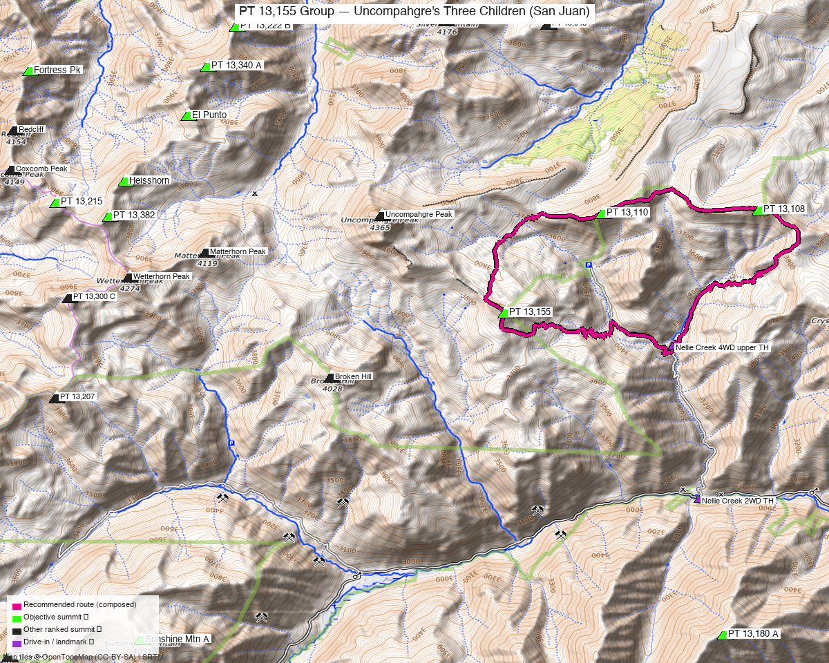
Note: the recommended route was distilled from 9 recorded GPS tracks of real trips (14ers.com · ListsofJohn · peakbagger) — all layered on the interactive CalTopo research map.
Peaks covered
Three unnamed 13ers on the ridge system directly north and east of Uncompahgre Peak, entirely within the Uncompahgre Wilderness (GMUG National Forest). No permits or fees. All three summits appear on the Uncompahgre Peak quad; the traverse runs west-to-east along a high tundra plateau above 13,000'. The road corridor — Nellie Creek Road (FR877) off CR20 west of Lake City — is the same one used for Uncompahgre Peak.
| Peak | Elev | Class | CO rank | Status |
|---|---|---|---|---|
| PT 13,155 | 13,155' | 2 | 523 | unclimbed |
| PT 13,110 | 13,110' | 2 | 562 | unclimbed |
| PT 13,108 | 13,108' | 2 | 564 | unclimbed |
Recommended route — the recommended line ⭐
12.0 mi · ~4,292 ft, Class 2+ — A lollipop-style loop from the Nellie Creek 4WD start. The approach follows the Uncompahgre Peak trail to roughly 12,000', then breaks west across a tundra basin to the NW ridge of PT 13,155. The summit ridge is narrow and "somewhat airily exposed" with loose rock on the SE approach to the cairn (Class 2+). From 13,155, the route traverses east through a 12,380' saddle to PT 13,110 — a short tundra stroll (Class 2) — then continues east on Trail 232 to the broad plateau of PT 13,108 (Class 2). The return retraces to the Uncompahgre Peak trail and back to the trailhead. One all-objectives summer recording (trk_loj_2257, Jun 2016) documents this exact loop at 13.4 mi RT; the composed line trims a ~1.4 mi non-objective side-trip to Crystal Peak that the recording includes.
Route sequence
- Nellie Creek TH (4WD, 10,511') — start up the Uncompahgre Peak trail.
- At ~12,000' leave the main trail and head SW across a tundra basin toward the NW ridge saddle of PT 13,155.
- PT 13,155 (13,155') — follow the narrow SE ridge to the cairn; "somewhat airily exposed" with loose rock. Class 2+.
- Descend E from 13,155, crossing a ~12,380' pass, to PT 13,110 (13,110') — short, easy tundra stroll. Class 2.
- Continue east on Trail 232 across the "high, vast tundra plateau" to PT 13,108 (13,108'). Class 2.
- Retrace west along Trail 232 / Uncompahgre Peak trail and descend Nellie Creek back to the trailhead.
Getting there — Nellie Creek TH (4WD) (10,511')
| Drive from Boulder | 7h 25m via Google Maps |
| Trailhead | Nellie Creek TH (4WD), 38.04757, -107.4058, 10,511' |
| Road | Lake City → CR20 west ~5.2 mi → FR877 (Nellie Creek Road). The spur road above the junction is grade3 / smoothness=very_bad (OSM way/383756729, Forest Service) — high-clearance 4WD required. The climb13ers pages list the uppermost road-end TH at 11,425' (4x4 only) but the start used here is the grade3 fork at 10,511' where both recorded tracks begin. |
| Land | Uncompahgre Wilderness / GMUG National Forest — no permits, no fees, foot traffic only on the high terrain. |
Gear & season
- Best window: Mid-July through September. The only all-objectives summer recording is from June 2016 (shoulder); two tracks are winter/late-season (May 2023, November 2020) and confirm the route but are not recommended. Expect lingering snow on the north-facing tundra and summit ridge into early July.
- Terrain: Class 2 tundra walking for PT 13,110 and PT 13,108. PT 13,155 is Class 2+ — the summit SE ridge is narrow and airy with loose rock; careful footwork is warranted but no technical gear required.
- Storms: The ridge traverse is exposed with few bail points once past 13,000'. Early alpine start — plan to be off the ridge by midday.
- Cell: Limited in the Nellie Creek drainage; carry an InReach.
- Water: Nellie Creek provides water low on the approach; the high tundra plateau is dry.
Other considerations
Far-from-home (7h 25m drive): With a ~7.3h one-way drive, Nellie Creek is not a casual weekend objective from Boulder — plan for an overnight at Lake City or camp near the trailhead. Uncompahgre Peak (14,318') shares the Nellie Creek access road exactly, but Kyle has already climbed it, so this report stands alone.
The trio or the duo? The climb13ers beta for PT 13,110 and PT 13,108 notes that PT 13,155 can be added "across the valley" when time and weather allow — the recorded all-objectives track confirms the linkup is efficient (13.4 mi RT, same trailhead). No meaningful reason to split the trip across days.
Crystal Peak: The recorded party visited Crystal Peak (non-objective, ~1.4 mi RT side-trip east of PT 13,108) on their return. The composed line omits it via trim_spurs; add it back if you want another summit — it does not change the recommended trailhead or approach.
Matterhorn Peak (13,590') and the Big Blue / Matterhorn Creek drainage objectives are on the opposite side of the divide and require a separate approach — they do not combine from Nellie Creek.
Trip reports & GPX (all three sources)
Sources confirmed logged in: 14ers.com ("Basin"), listsofjohn.com ("letsgocu"), peakbagger.com ("Kyle Knutson"). All three swept fresh for this build, plus the mapped OSM trails in the bbox — all layered on the research map.
-
14ers.com: 1 track harvested (+4 duplicates of another source). The single 14ers track (trk_14ers_1, Sep 2012, 11.2 mi one-way) is a transit to Uncompahgre Peak and covers none of the three objectives — not used in the recipe.
-
listsofjohn.com: 3 tracks harvested (+3 duplicates of another source). trk_loj_2257 (Jun 2016, shoulder, all 3 objectives, 13.4 mi RT from 10,752' — recipe track); trk_loj_16396 (undated drawn line, 17.0 mi, opposite traverse direction — rejected, no timestamps); trk_loj_9087 (Oct 2020 shoulder, PT 13,110 only from lower 9,429' TH — rejected, insufficient coverage).
-
peakbagger.com: 5 tracks harvested (+7 duplicates of another source). trk_pb_2 (May 2023, winter — all 3 objectives, same direction as recipe, confirms route but excluded); trk_pb_1 (Jul 2025, PT 13,155 only, one-way from 12,930', high camp descent); trk_pb_3 (Aug 2021, PT 13,155 only from 9,865'); trk_pb_4 (Oct 2020 shoulder, PT 13,110 only, lower TH); trk_pb_5 (Nov 2020, winter, PT 13,108 only). All five rejected — winter, insufficient coverage, or one-way from high start.
Sources checked: 14ers.com ✓ (logged in, "Basin") · listsofjohn.com ✓ (logged in, "letsgocu") · peakbagger.com ✓ (logged in, "Kyle Knutson")