Snowdon Peak + "South Snowdon" — Andrews Lake / Crater Lake trail (San Juan, Class 2+)
Other climbers: Emily Sharpe — not yet · Shawn D Keil — not yet
At a glance — recommended day
11.7 mi · 3,277 ft gain · Class 2 · 2 peaks · ~8.62 h drive
NOAA weather link: Snowdon Group Weather
CalTopo research map: https://caltopo.com/m/QQPQ5DJ
Researched: 2026-07-30
Status in Peak Checklist: both unclimbed. This is the Molas Pass cluster — you have already climbed Twilight, North Twilight, West Needle, Grand Turk and Sultan nearby, so Snowdon and its southern neighbour are the obvious remaining pair from this trailhead.
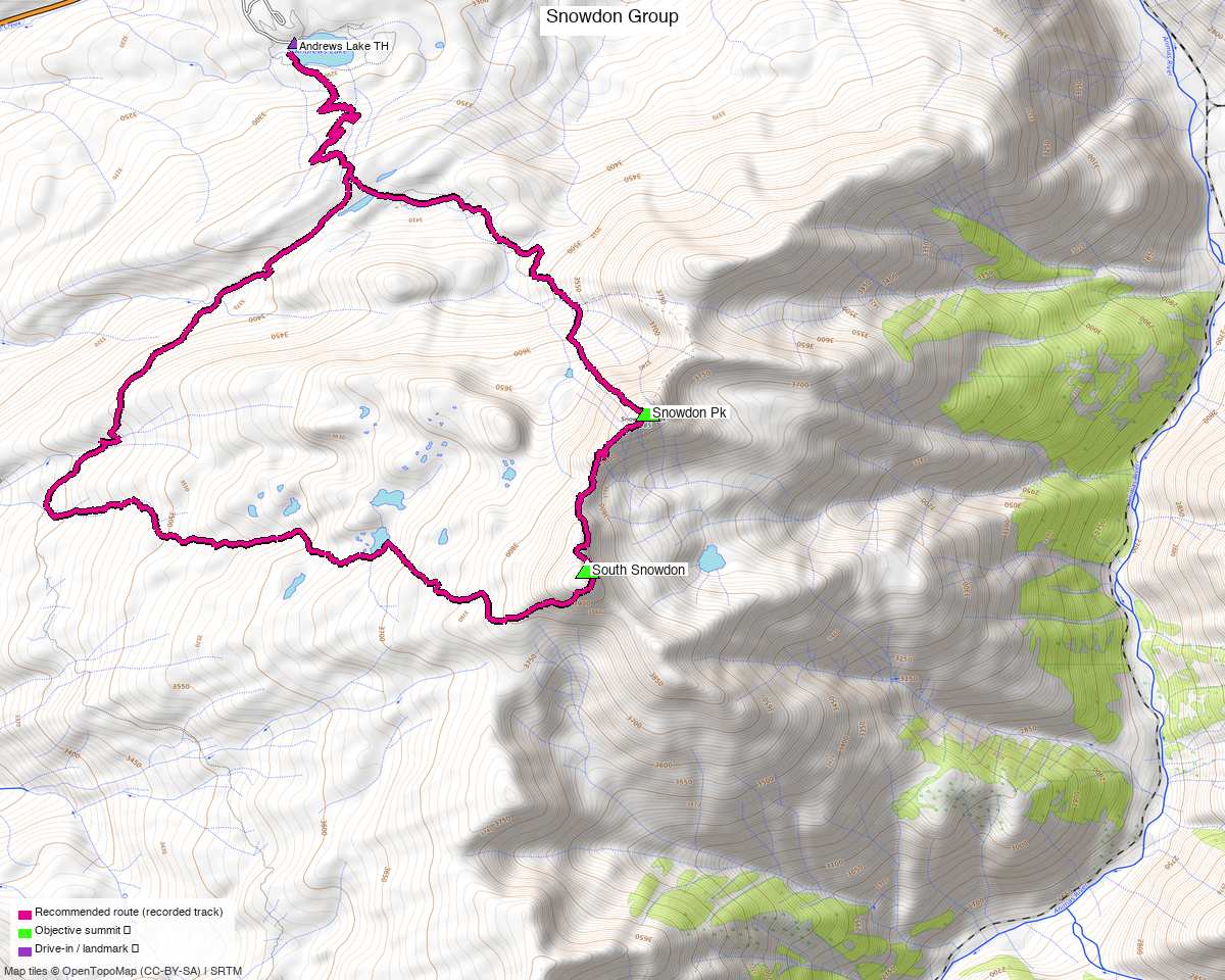
Note: the recommended route was distilled from 12 recorded GPS tracks of real trips (14ers.com · ListsofJohn · peakbagger) — all layered on the interactive CalTopo research map.
Peaks covered
Snowdon Peak is the prominent one — 1,330 ft of rise, a BGN-named summit, and the peak that gives the quad its name. Its southern neighbour is officially "N 2" on Lists of John, with "South Snowdon" recorded as an alternate name; it is a modest 391 ft rise off Snowdon itself, which is its line parent.
| Peak | Elev (LiDAR) | Class | CO rank | Rise | Status |
|---|---|---|---|---|---|
| Snowdon Peak | 13,090' (map 13,077') | 2+ | 574 | 1,330' | unclimbed |
| "N 2" / "South Snowdon" | 13,060' (map 13,046') | 2 | 600 | 391' | unclimbed |
San Juan County, Snowdon Peak quad — San Juan National Forest, above Molas Pass on US-550. No permits or fees.
Note the grade: peak_db lists both as plain Class 2. Lists of John rates Snowdon 2+, and that is what this report's headline uses.
Recommended route — Andrews Lake ⭐
~11.7 mi · ~3,277 ft round trip, Class 2+, from the Andrews Lake TH (10,761').
This is one day, not two. Seven independent recorded parties link both summits in a single round trip, and all 12 recorded tracks start from the same paved lot:
| Recording | Distance | Summit order | Season |
|---|---|---|---|
trk_14ers_2 |
9.5 mi | Snowdon → South Snowdon | ⚠ winter (2021-05) |
trk_14ers_1 ⭐ |
11.7 mi | Snowdon → South Snowdon | summer (2024-08) |
trk_loj_4247 |
13.7 mi | South Snowdon → Snowdon | summer (2017-07) |
trk_pb_3 |
14.6 mi | Snowdon → South Snowdon | summer (2020-07) |
trk_pb_4 |
14.7 mi | Snowdon → South Snowdon | summer (2023-08) |
trk_loj_14449 |
19.2 mi | South Snowdon → Snowdon | shoulder (2023-06) |
trk_14ers_3 |
23.3 mi | South Snowdon → Snowdon | summer (2026-07) |
The recommended line follows trk_14ers_1 verbatim — the shortest all-summer track that
reaches both summits, from August 2024, returning within 42 ft of its start.
Two of the recorded tracks are winter lines — do not follow them in summer
The shortest both-peak recording, trk_14ers_2 at 9.5 mi, is a May 2021 snow line, and
trk_loj_9270 (South Snowdon only) is from December 2020. Snow travel takes slopes that
are not the summer walking route, so neither is used here despite being shorter. If you look at
the research map, the two winter tracks are the ones cutting directly up the basin.
A composed line was also evaluated and rejected on season: the route composer proposed
7.66 mi, but built it from an undated track, a June shoulder track and that December line. The
composer scores distance, gain and trail fraction with no notion of season — a known gap
(composer-season-blind). Since summer beta covering both peaks exists, there is no reason to
publish a winter-derived line. Worth re-testing once the composer penalises winter: the ~4 mi
it claims to save is real.
Route sequence
- From the Andrews Lake TH (10,761'), take the Crater Lake trail south.
- Leave the trail for Snowdon Peak (13,090') — the Class 2+ summit and the crux.
- Continue south along the ridge to "South Snowdon" / "N 2" (13,060').
- Return north to the trailhead.
Getting there — Andrews Lake TH (Molas Pass, US-550)
| Drive from Boulder | ~8h 40m via Google Maps — 384 mi |
| Trailhead | Andrews Lake TH, 37.72814, −107.71071, 10,761' — paved public parking (access=yes, fee=no), where all 12 recorded tracks begin |
| Road | Andrews Lake Road is paved, smoothness=good, straight off US-550 at Molas Pass. No 4×4 needed — any car reaches this trailhead. |
| Forest | San Juan National Forest — no permits or fees; standard LNT. |
The access here is as easy as San Juan trailheads get: a paved spur off a paved highway pass, with a maintained lot and a USFS information board. The difficulty is entirely in the drive length and the day itself.
Gear & season
- Best window: July through September. Five of the twelve recorded tracks are summer; two are winter and two are undated, which is a reminder that this is a popular ski objective as well as a summer walk-up.
- Terrain: Class 2+ on Snowdon, Class 2 on the southern summit — talus and tundra above the Crater Lake trail. No rope in season.
- Vehicle: any car.
- Storms: the day is largely above treeline once you leave the trail — classic San Juan afternoon monsoon exposure, so start early.
- Cell: patchy; carry an InReach.
Other considerations
This is a long drive for a moderate day. At ~8h 40m each way, ~11.7 mi and ~3,277 ft is modest for the commitment. The trailhead sits directly on US-550 at Molas Pass, which makes it unusually easy to combine with anything else in the Silverton area — worth pairing rather than driving nine hours for a single half-day.
The summit marker for "South Snowdon" needs a look. summit_from_tracks flagged it as
MANUAL — the track-derived summit sits ~188 ft from the peak_db coordinate across 6 recordings,
which is beyond the automatic threshold. Snowdon's own marker was moved automatically (~100 ft).
The southern summit is broad, so the discrepancy is plausible rather than alarming, but it has not
been resolved here.
Trip reports & GPX (all three sources)
Sources confirmed logged in: 14ers.com ("Basin"), listsofjohn.com ("letsgocu"), peakbagger.com ("Kyle Knutson"). All three swept across both objective peaks and deduped, plus the 95 mapped OSM ways of the Molas Pass / Crater Lake / Colorado Trail network — all layered on the research map.
- 14ers.com: peaks 10570 (Snowdon), 10587 — 3 GPX-library tracks (plus 2 that duplicated another source).
- listsofjohn.com: peaks 739, 778 — 4 tracks harvested from 11 trip reports, and the Class 2+ / 2 ratings this report's grade rests on.
- peakbagger.com: peaks 16664, 60855 — 5 ascent tracks with GPS (plus 1 duplicate).
Sources checked: 14ers.com ✓ (logged in, "Basin") · listsofjohn.com ✓ (logged in, "letsgocu") · peakbagger.com ✓ (logged in, "Kyle Knutson")