Homestake Pk (13,217', Northern Sawatch) — Slide Lake approach
Other climbers: Emily Sharpe — not yet · Shawn D Keil — not yet
At a glance — recommended day
4.8 mi · 1,712 ft gain · Class 2 · 1 peak · ~3.5 h drive
NOAA weather link: Homestake Pk (13,217', Northern Sawatch) — Slide Lake approach Weather
Drive from Boulder: 3h 30m via Google Maps
CalTopo research map: https://caltopo.com/m/5Q2GCKV
Researched: 2026-08-12
Status in Peak Checklist: unclimbed. A Northern Sawatch walk-up sitting just west of Tennessee Pass, Homestake Pk is an isolated ranked peak with a relatively short drive (~3.5 h) and a clean summer line via West Tennessee Creek — a good candidate for a day when a short, straightforward Sawatch outing fits the schedule.
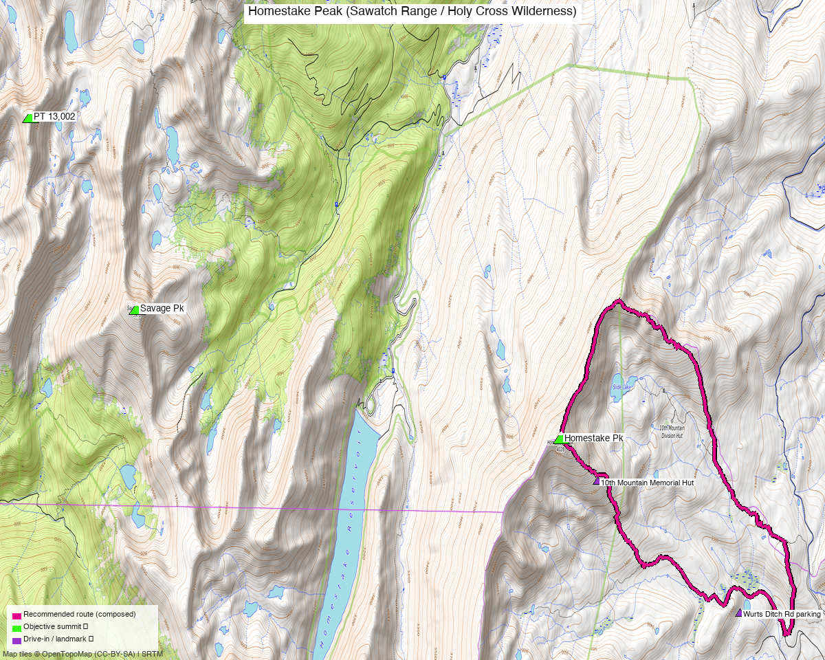
Note: the recommended route was distilled from 8 recorded GPS tracks of real trips (14ers.com · ListsofJohn · peakbagger) — all layered on the interactive CalTopo research map.
Peaks covered
Homestake Pk (13,217', CO rank 474) sits in the Northern Sawatch Range roughly two miles west of Tennessee Pass, within the Pike–San Isabel National Forest. The summer approach follows West Tennessee Creek up County Road 19 — no permits or fees required for a day hike. The peak is isolated: no close neighbors share the trailhead or approach infrastructure.
| Peak | Elev | Class | CO rank | Status |
|---|---|---|---|---|
| Homestake Pk | 13,217' | 2 | 474 | unclimbed |
Recommended route — the recommended line ⭐
4.8 mi · ~1,712 ft, Class 2 — out-and-back from the 4WD Slide Lake TH up West Tennessee Creek, crossing open tundra to gain the broad ridges below the summit; grassy walking gives way to straightforward rock-hopping near the top. Route built from trk_pb_4 (Jun 2024, peakbagger), the only non-winter recording from the correct Slide Lake approach.
Route sequence
- Slide Lake TH (4WD, ~10,420') — head west up the West Tennessee Creek drainage on road/trail
- Slide Lake area — continue northwest on open tundra as terrain opens above treeline
- Homestake Pk (13,217') — broad walk-up summit; views across the Continental Divide and toward the Holy Cross Wilderness to the south
- Return via the same line to the trailhead
Getting there — Slide Lake TH (West Tennessee Creek, 4WD) (10,420')
| Drive from Boulder | 3h 30m via Google Maps |
| Trailhead | Slide Lake TH (West Tennessee Creek, 4WD), 39.34946, -106.35979, 10,420' |
| Road | CR 19 (West Tennessee Road) is tagged 4wd_only / smoothness=very_bad (OSM ways 17080054, 17078066); the upper Slide Lake spur is smoothness=horrible / tracktype=grade3 (way 361978231). High clearance is required to reach the TH proper (picnic table, fire ring, primitive camping). Vehicles without 4WD can park ~3 mi back near the Wurts Ditch Road junction (~10,490'), adding ~6 miles and minimal extra gain to the day. |
| Land | Pike–San Isabel National Forest. No permit or fee required for day hiking. |
Gear & season
- Best window: July–September once the 4WD road clears. The Jun 2024 track (trk_pb_4, the route basis) is the earliest confirmed recording from the Slide Lake approach; 2 summer-dated tracks confirm conditions open by July.
- Winter / early-season alternative: When CR 19 is unplowed, parties use the Crane Park / East Ridge approach from the US-24 corridor (~10,145'). Three winter tracks (Nov, Dec, Jan) and one Apr track document that line — same Class 2 grade but ~13 mi RT from Crane Park. Not the summer line.
- Terrain: Broad Northern Sawatch tundra — grassy meadows along the creek, open ridge to the summit, finishing on talus/rock-hopping near the top. No technical difficulty; straightforward navigation.
- Gear: Standard summer hiking kit; no axe or technical equipment needed.
- Afternoon storms: Typical Colorado pattern — target the summit before noon.
- Cell: Expect limited or no signal in the West Tennessee Creek valley.
Other considerations
2WD option: If the 4WD upper road is a concern, park near the Wurts Ditch Road junction (39.35650, -106.35329, ~10,490') and walk the road to the TH proper — roughly 3 miles each way on gentle grade. The LoJ track (trk_loj_1257, Jul 2013) covers this approach up to the valley but stops short of the summit; the road extension to the TH is easy walking.
Winter / East Ridge approach: From Crane Park (east side of US-24, ~10,145') the East Ridge is ~13 mi RT / ~3,000 ft — same Class 2 grade, documented by three winter tracks (Dec 2013, Apr 2020, Jan 2022) and the Nov 2020 14ers.com TR. Reserve this for shoulder season when CR 19 is closed.
Combinations: Homestake Pk is an isolated ranked peak; find_peaks_near.py found no close neighbors sharing the approach or trailhead. Drive time (~3.5 h) is below the far-from-home pairing threshold, so a solo day trip makes sense.
Trip reports & GPX (all three sources)
Sources confirmed logged in: 14ers.com ("Basin"), listsofjohn.com ("letsgocu"), peakbagger.com ("Kyle Knutson"). All three swept fresh for this build, plus the mapped OSM trails in the bbox — all layered on the research map.
-
14ers.com: 3 tracks harvested (+3 duplicates across other sources) — all from the Crane Park / East Ridge approach (Nov 2020, Dec 2013, Jan 2022); the 14ers.com page lists the East Ridge as the standard route. Class 2, consistent across all reports.
-
listsofjohn.com: 1 track harvested (+3 duplicates across other sources) — trk_loj_1257 (Jul 2013), starting from the 2WD Wurts Ditch Road junction and covering the West Tennessee Creek valley approach; does not reach the summit, confirming this as the 2WD parking area.
-
peakbagger.com: 4 tracks harvested (+4 duplicates across other sources) — trk_pb_4 (Jun 2024) is the route basis, starting from the 4WD TH on West Tennessee Road and covering Homestake Pk; trk_pb_2 (Jul 2022) covers the East Ridge from Crane Park; trk_pb_3 (May 2024) is early-season shoulder from an intermediate parking point; trk_pb_1 (Mar 2021) is a descent-only winter track from near the summit.
Sources checked: 14ers.com ✓ (logged in, "Basin") · listsofjohn.com ✓ (logged in, "letsgocu") · peakbagger.com ✓ (logged in, "Kyle Knutson")