PT 13,180 A — Alpine Gulch loop above Lake City (Class 2)
Other climbers: Emily Sharpe — not yet · Shawn D Keil — ✓ climbed
At a glance — recommended day
9.49 mi · 4,424 ft gain · Class 2 · 1 peak · ~7.01 h drive
NOAA weather link: PT 13,180 A Weather
CalTopo research map: https://caltopo.com/m/RA7KBD7
Researched: 2026-07-28
Status in Peak Checklist: unclimbed. A quiet, trail-fed Class 2 day at the head of Alpine Gulch outside Lake City — no exposure, no scrambling on the recommended line, and a passenger-car trailhead, which is unusual this deep in the San Juans. The recommended day is a loop: up the Alpine Gulch trail, down the direct northwest slopes — ~9.5 miles and ~4,420 ft, with the creek crossings, not the summit, as the crux.
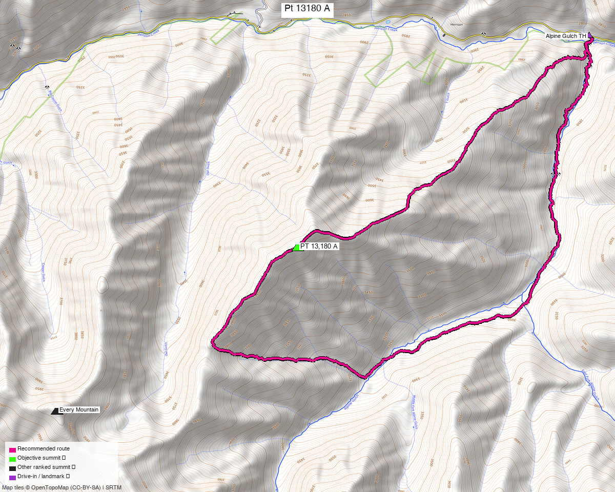
Note: the recommended route was distilled from 6 recorded GPS tracks of real trips (14ers.com · ListsofJohn) — all layered on the interactive CalTopo research map.
Peaks covered
One Class 2 peak in the San Juan Mountains, at the head of Alpine Gulch southwest of Lake City.
| Peak | Elev | Class | CO rank | Prom | Isolation | Status |
|---|---|---|---|---|---|---|
| PT 13,180 A | 13,170' (LiDAR; map 13,180') | 2 | 506 | 521' rise | 2.06 mi | unclimbed |
Hinsdale County, Redcloud Peak quad — Redcloud Peak Wilderness Study Area, Gunnison NF. No permits or fees.
Three names for one summit — worth knowing before you search
LiDAR took 10 ft off this peak, and the sources have not converged on what to call it:
- peak_db / ListsofJohn: PT 13,180 A — LoJ's page is titled "13170"
- 14ers.com: Unnamed 13170
- climb13ers: UN 13170 — "formerly UN 13180 B" (note the B, not A)
All four refer to the same summit: CO rank 506, 13,170' LiDAR / 13,180' map, San Juan, Class 2, Hinsdale County. climb13ers' letter differs from peak_db's — don't let it convince you you've found a different peak.
Recommended route — up Alpine Gulch, down the direct NW slopes ⭐
~9.5 mi · ~4,420 ft round trip, Class 2, a loop from the Alpine Gulch TH (9,011').
This is a walk-up with a long approach, and it is deliberately built as a loop of two recorded corridors rather than an out-and-back:
| Leg | Line | Distance |
|---|---|---|
| Ascent | the Alpine Gulch trail to the summit — the published Class 2 route | 6.35 mi |
| Descent | the direct northwest slopes straight back to the trailhead | 3.13 mi |
Going up the trail and down the direct side saves ~3.6 miles against looping the gulch both ways (13.1 mi), for the same gain. climb13ers rates the Alpine Gulch route Class 2 and files it under "long day // back for dinner" at 12.4 mi / 4,195' — the ascent leg here is that route. Exposure is none, routefinding is moderate, and the terrain is tundra, chiprock and rubble with some tree-bashing low down.
Why down the direct side, and the one thing to check
climb13ers' party went up a steep gully on this side and called it "a very difficult Class 2+ scramble… we don't recommend going up this way" — but then said of their own descent line: "The route we took to come down makes a far better ascent route." The direct side is the better descent even where it is a poor ascent, which is how it is used here.
Being straight about the evidence: the descent leg is a recorded track (LoJ, Alyson Kirk, 2016-09-01) whose trip report contains no written description — the line is real and somebody walked it, but no source grades it. Treat it as the steeper, looser half of the day. If it looks bad from the summit, reversing the ascent route costs ~3.6 extra miles on known Class 2 ground.
Route sequence
- From the Alpine Gulch TH (9,011'), the trail drops steeply to a bridge over Henson Creek — you lose elevation before you gain any.
- Follow the creek ~2.5 mi upstream (south) to a signed trail fork. The East Fork is the Grassy Mountain trail; take the right fork, continuing southwest up Alpine Gulch.
- Below the junction expect at least three pairs of creek crossings — back and forth across the bottom of the gulch. Most have logs, and they thin out as you climb. This is the crux of the route (see below).
- The right fork climbs out of the drainage to a flat bench with excellent camping, then passes through aspen. Beyond here the West Fork trail fades out — expect game trails and some bushwhacking.
- Continue ~0.7 mi up-valley to the base of an open, east-facing grass-and-tundra hillside (turn-up around 37.98223, −107.38629).
- Head west and uphill for ~1,200 vertical feet. Where the drainage splits, the left branch is the easier line; the right is steeper.
- Gain the southwest ridge and walk it to the 13,170' summit.
- Descend the direct northwest slopes — off the summit, drop northeast then east down the open slopes straight toward Henson Creek, rejoining the road at the trailhead. This is the 3.1-mile half of the loop; it is steep and loose, and it saves the 6.4-mile return down the gulch.
The creek crossings are the crux — pick your week
climb13ers is explicit that the bottom-of-the-gulch trail "would not be a good trail in higher runoff. The crossings would be much more difficult." On this route the hazard is water, not rock — there is no exposure anywhere on the recommended line. Go after snowmelt has finished, and treat an early-season attempt as a different, harder outing.
Don't take the east-ridge gully. climb13ers' own party ascended a steep, loose gully to the east ridge and called it "a very difficult Class 2+ scramble… we don't recommend going up this way." The line above — the one the recorded tracks follow — is the Class 2 route.
Getting there — Alpine Gulch TH (9,011')
| Drive from Boulder | ~7h 05m via Google Maps — via Lake City |
| Trailhead | Alpine Gulch TH, 38.01956, −107.35856, 9,011' (OSM "Alpine Gulch Trailhead" parking node), ~2 mi west of Lake City on Henson Creek Rd |
| Road | Passenger-car accessible. Engineer Pass Rd here is surface=compacted, tracktype=grade1; climb13ers lists the trailhead as passenger-car, and LoJ TR 20632 confirms "2wd to reach from Lake City." No 4×4 needed — rare for a San Juan 13er. |
| Land | Redcloud Peak Wilderness Study Area, Gunnison NF — no permits/fees; standard LNT. |
The other approach. One recorded track (trk_loj_899, 16.6 mi) starts 8.0 mi away at the
Silver Creek / Grizzly Gulch TH (10,426') at the end of Cinnamon Pass Rd — smoothness=horrible,
4×4 terrain. That was a 2011 link-up taking in Every Mountain, Cooper Creek Peak and "Sundog"
alongside this summit. Kyle has already climbed all three, so that approach no longer buys
anything, and the 2WD Alpine Gulch side is both easier to reach and shorter.
Gear & season
- Best window: July through September, and later in that window is better — the creek crossings are the deciding factor, not the summit.
- Terrain: Class 2 — trail, then tundra and rubble. No rope, axe or crampons in season. Exposure: none.
- Water: you will cross the creek repeatedly; expect wet feet and carry the ability to dry out.
- Navigation: moderate routefinding. The West Fork trail fades and the turn-up onto the tundra hillside is unmarked — carry the GPX. ⚠️ One swept track (2023-05-28) is a snow-season ascent and is not the basis of this route; 14ers.com records 1 winter ascent and 2 ski descents.
- Bushwhacking: climb13ers hit avalanche debris across the trail in 2008 and had to skirt it. Expect some deadfall and tree-bashing in the upper gulch.
- Storms: ~13 mi means a long day above treeline late — start early.
- Cell: assume none past Lake City; carry an InReach.
Other considerations
Nothing left to pair it with nearby — Kyle has cleaned out this basin. Every ranked peak within 4 miles is already climbed: Every Mountain (2.1 mi), Cooper Creek Peak (2.5 mi), PT 13,820 (3.1 mi), PT 13,838 (3.4 mi) and "Gudy Pk" (3.9 mi). Redcloud, Sunshine, Uncompahgre, Wetterhorn, Matterhorn and Handies are all done too. That is why this reads as a one-peak trip: the obvious link-ups were used up on previous visits.
But 7 hours each way for one Class 2 summit deserves a second objective. Still unclimbed within ~12 miles: PT 13,110 (5.3 mi), PT 13,108 (5.3 mi), Sunshine Mtn A (6.2 mi), PT 13,094 (7.6 mi), PT 13,382 (8.3 mi), plus the Class 3 pair "Heisshorn" (8.5 mi) and "El Punto" (8.6 mi). Two already have reports — see PT 13,155 Group and Campbell Creek Pk. Whether any of them combine with this one is a trailhead-proximity question, not a summit-distance one, and it hasn't been answered yet — worth running before committing to the drive.
Solitude. 74 LoJ members and 79 on 14ers.com have logged this summit, against thousands on Redcloud and Sunshine a few miles south. The Wilderness Study Area sees very little traffic.
Trip reports & GPX (all three sources)
Sources confirmed logged in: 14ers.com ("letsgocu"), listsofjohn.com, peakbagger.com. All three swept, plus 4 mapped OSM trails in the Alpine Gulch basin — all layered on the research map.
- 14ers.com: peak page 10517 — 3 GPX-library entries (2 unique after dedup), 79 member ascents, 1 winter ascent, 2 ski descents. No formal route description.
- listsofjohn.com: peak 625 — Class 2; 5 trip reports and 4 downloadable tracks. TR 20632 (whileyh, 2021-08-15) is the source of the recommended ascent: "C2 route via the Southwest Ridge from Alpine Gulch West Fork (2wd to reach from Lake City)." TR 7236 (Alyson Kirk, 2016-09-01) is the descent leg — a complete 6.3 mi round trip up and down the direct northwest slopes, with no written description (its report body is just "GPX."). TRs 1828 and 5273 climb the peak combined with Every Mountain + Cooper Creek Peak from the Cooper Creek / Silver Creek side.
- peakbagger.com: peak 84939 — 2 ascents with GPS tracks; both proved byte-identical to tracks already harvested from LoJ/14ers, so they corroborate the route rather than adding new coverage.
- climb13ers.com: UN 13170 via Alpine Gulch — Class 2, 12.4 mi / 4,195', passenger-car trailhead, full route description (the creek-crossing warning and the east-ridge caveat both come from here).
Sources checked: 14ers.com ✓ (logged in, "letsgocu") · listsofjohn.com ✓ (logged in) · peakbagger.com ✓ (logged in) · climb13ers.com ✓