Campbell Creek Pk (13,461', Lake City San Juans) — Grizzly Gulch Route
Other climbers: Emily Sharpe — not yet · Shawn D Keil — not yet
At a glance — recommended day
6.4 mi · 3,372 ft gain · Class 2 · 1 peak · ~7 h drive
Drive from Boulder: ~7h via Google Maps
CalTopo research map: https://caltopo.com/m/A717SC7
Researched: 2026-08-07
Status in Peak Checklist: unclimbed. This is the lone hole in an otherwise-finished neighborhood — Handies, Sunshine, Redcloud, Whitecross, PT 13,801, Quarter, "Sundog," and "Tundra Top" are all climbed, leaving Campbell Creek Pk as the only unclimbed ranked summit within four miles of the Grizzly Gulch trailhead. One moderate day closes out the entire Lake Fork cluster.
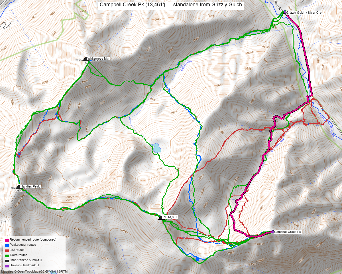
Note: the recommended route was distilled from 7 recorded GPS tracks of real trips (14ers.com · ListsofJohn · peakbagger) — all layered on the interactive CalTopo research map.
Peaks covered
Campbell Creek Pk (formerly UN 13,454; LiDAR added 7 feet) sits in the Lake City San Juans on the ridge complex running southeast off Handies Peak, between Grizzly Gulch and the head of Campbell Creek. This is primarily BLM land (climb13ers notes the National Forest maps cover it poorly for exactly that reason — Trails Illustrated #141 is the map that does), on the Redcloud Peak quadrangle. No permits or fees — the trailhead parking is mapped fee-free, and camping is at-large above Sherman.
| Peak | Elev | Class | CO rank | Status |
|---|---|---|---|---|
| Campbell Creek Pk | 13,461' | 2 | 284 | unclimbed |
Recommended route — the recommended line ⭐
6.4 mi · ~3,372 ft, Class 2 — an honest out-and-back up Grizzly Gulch and over the intervening ridge points, following the October 2021 14ers.com recording (trk_14ers_3) trailhead → summit → trailhead with that party's side-spurs trimmed. The line matches the climb13ers-described route almost exactly (their map estimate is 6.8 mi / 3,800'): a mile of good trail, a steep but well-footed gully to treeline, then broad tundra ridge walking with one short rocky section, a contouring traverse through the head of Campbell Creek, and a final half-mile of mixed tundra and rock on the west ridge. Exposure is essentially none; routefinding is moderate (picking the right gully and holding the ~12,800' contour are the two decisions that matter). Every recorded party that started here either did this line or extended it to tag PT 13,801/Handies — which is why the recommended route is shorter than any full recording.
Route sequence
- Grizzly Gulch / Silver Creek TH (10,440') — cross the Lake Fork on the sturdy footbridge behind the vault toilet and start up the Grizzly Gulch (Handies Peak) trail WSW through open forest, sharing the first mile with the 14er crowd.
- ~11,125', 1 mi up — leave the trail: cross the creek and ascend the westernmost of the three parallel avalanche gullies descending off Pt 12,792. Steep but good footing; game trails on the left (climber's) side keep you out of the willows. The gully constricts halfway, then opens; trees end near 12,000'.
- Pt 12,792 → Pt 13,502 — open tundra walking (July wildflowers per the beta), one short rocky section just below Pt 13,502.
- SSW along the ridge — drop to the saddle below PT 13,801, then leave the saddle left on a contouring descent into the head of Campbell Creek, staying above ~12,800'. Early-to-mid season this bowl holds snowfields — the ice-axe terrain on the day.
- West-ridge saddle (~0.5 mi west of the summit) — regain the ridge at the saddle east of the broken-rock section of the 13,801 connecting ridge; a game trail leads to it.
- Campbell Creek Pk, 13,461' — follow the ridge ENE on mixed tundra and rock. The summit itself is plain, but the views down the Lake Fork valley, the 3,500' drop into Cottonwood Creek, and the Grenadiers to the south are the payoff.
- Return — retrace: contour back through the Campbell Creek head, over Pt 13,502 and Pt 12,792, down the gully to the trail, out to the bridge.
Getting there — Grizzly Gulch / Silver Creek TH (10,440')
| Drive from Boulder | ~7h via Google Maps |
| Trailhead | Grizzly Gulch / Silver Creek TH, 37.93699, -107.46096, 10,440' |
| Road | From Lake City: HWY 149 south ~2 mi, then CR3/CR30 (BLM 3306) around Lake San Cristobal and up the Lake Fork past the Williams Creek and Mill Creek campgrounds to the Sherman junction (14.4 mi) — passenger-car to Sherman. The right fork (Cinnamon Pass Rd) climbs the last ~4 mi to the TH: high clearance advisable (climb13ers; OSM tags the upper miles surface=gravel/unpaved, smoothness=very_bad to horrible, tracktype=grade1–2). ~18.5 mi and the better part of an hour from Lake City. Weekend parking is tight — squeeze in where you can; vault toilet at the TH. |
| Land | BLM (Lake Fork / Redcloud–Handies country — not National Forest, which is why NF maps cover it poorly; use Trails Illustrated #141). No permits, no fees (fee=no on the mapped TH parking). At-large camping at and above the TH and near Sherman — mind the private parcels along the upper road; Williams Creek and Mill Creek CGs down-valley fill on weekends. |
Gear & season
- Best window: July through early October. The recorded evidence spans June through October — 2 summer lines (Jul 2017, Jul 2024) and 5 shoulder lines (Jun 2016/2023, Oct 2020 ×2, Oct 2021, the last being the recommended line) — with zero winter recordings. July brings the wildflower show on the upper tundra.
- Ice axe early-to-mid season (climb13ers' explicit recommendation): the gully off Pt 12,792 and the snowfields in the head of Campbell Creek hold snow well into summer.
- Footwear for chiprock/scree/talus near the summit ridge; otherwise it's trail, gully, and tundra — no exposure, nothing technical at Class 2.
- Storms: everything above ~12,000' is open tundra ridge with no quick bail except back down the gully — standard San Juan monsoon discipline, summit by late morning.
- Cell: assume no service up the Lake Fork valley or at the TH; Lake City is the last reliable coverage.
Other considerations
- Pair it with Cuba Gulch on one drive. At ~7 h each way, this should not be a solo round trip. The only other unclimbed 13ers on the same road system are PT 13,179 (Class 2) and PT 13,003 (Class 1) — 1.07 mi apart next to Half Peak, reached from the Cuba Gulch corridor off the same CR30 at the Sherman junction. Camp near Sherman or at the Grizzly Gulch TH and make it a two-day trip: Campbell Creek one day, the 13,179/13,003 pair the other. That closes every remaining hole in this corner of the San Juans in one drive.
- The out-and-back is the honest shape. climb13ers' "combines well with UN 13,801" is moot — PT 13,801 and the whole surrounding cluster are already climbed. The only loop variants run over the broken-rock section of the Campbell Creek–13,801 connecting ridge (one deep gash mid-way); the recommended line deliberately stays east of it via the Campbell Creek contour, and re-crossing that terrain to repeat a climbed summit buys nothing.
- A shorter direct variant exists but starts nowhere. One LoJ party recorded a 6.2 mi round trip from a bare pullout on Cinnamon Pass Rd 0.9 mi south of the TH — there is no trailhead, parking, or mapped trail there, so it's noted only as evidence the south slopes go; the Grizzly Gulch line from the real TH is the recommendation.
Trip reports & GPX (all three sources)
Sources confirmed logged in: 14ers.com ("Basin"), listsofjohn.com ("letsgocu"), peakbagger.com ("Kyle Knutson"). All three swept fresh for this build, plus the mapped OSM trails in the bbox — all layered on the research map.
-
14ers.com: 3 track(s) harvested from the peak's GPX library (Jul 2017, Oct 2021, Jun 2023 — all unchanged since the prior sweep, delta-skipped on refresh). The Oct 2021 recording (trk_14ers_3) became the recommended line; the Jun 2023 track was rejected for a 0.25-mi recording gap.
-
listsofjohn.com: 2 track(s) harvested via the trip-report GPX path (gpx 2256 — the 2016 road-pullout direct line — and gpx 9014, an Oct 2020 Grizzly Gulch round trip; both delta-skipped as unchanged, +1 duplicate of a peakbagger track). The LoJ peak page also cross-verified peakbagger pid 84977 as the correct peak.
-
peakbagger.com: 2 track(s) harvested from ascent GPX on pid 84977 (Jul 2024 — the longest recorded day at 13.7 mi — and Oct 2020; +3 duplicates across sources). Both are multi-peak days extending past the objective, consistent with how this peak is usually bagged.
Sources checked: 14ers.com ✓ (logged in, "Basin") · listsofjohn.com ✓ (logged in, "letsgocu") · peakbagger.com ✓ (logged in, "Kyle Knutson")