Beaubien + Francisco + PT 13,569 + PT 13,226 — the Cielo Vista north group (Class 2)
Other climbers: Emily Sharpe — not yet · Shawn D Keil — ✓ all
At a glance — recommended day
13.3 mi · 4,988 ft gain · Class 2 · 4 peaks · ~6.39 h drive
NOAA weather link: Culebra Range Weather
CalTopo research map: https://caltopo.com/m/EC5LGD4
Researched: 2026-08-03
Status in Peak Checklist: all four unclimbed.
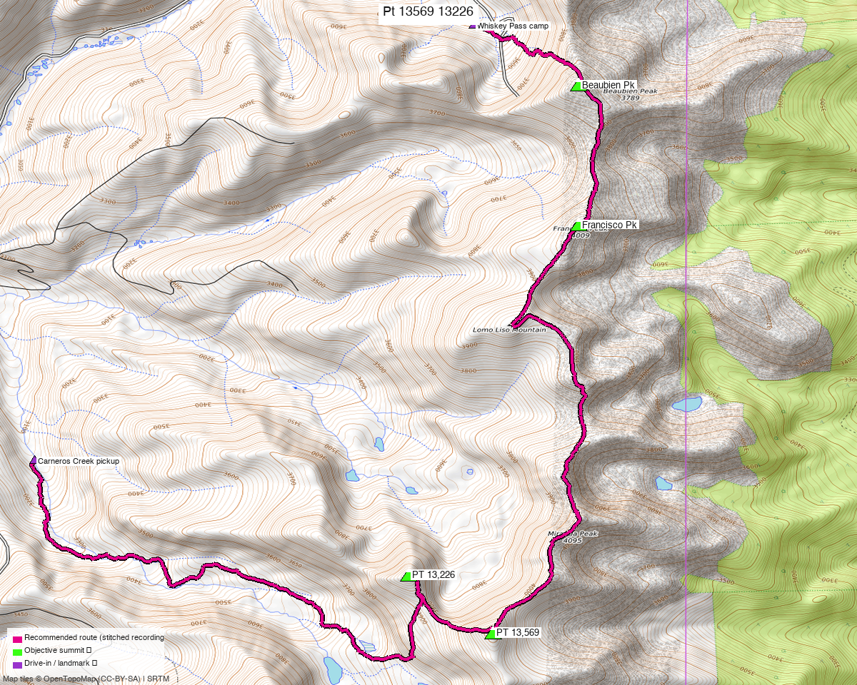
Note: the recommended route was distilled from 4 recorded GPS tracks of real trips (14ers.com · ListsofJohn) — all layered on the interactive CalTopo research map.
Private land — you cannot simply drive here and climb
All four summits are on Cielo Vista Ranch (~83,000 acres, Culebra Range). There is no public access, trespassing is actively prosecuted, and the ranch runs a booking process with a fixed fee. Read the access reference before anything else, and confirm current policy with the ranch — the terms below were current as of the June 2024 update and are volatile.
- $500 per group for the thirteeners, where "group" is geographic: Beaubien Peak through Culebra (this report) or Purgatoire Peak through Culebra. All four peaks here sit inside the one $500. You cannot combine them — "No, you cannot pay $500 to run the entire ridge in one day. Yes, I asked — it is still $1,000 total."
- Not the Culebra/Red booking form. Use the ranch contact form; staff follow up.
- No hiking or climbing August through December — hunting season.
- Two-person minimum for the thirteeners.
- 4WD required. "A Subaru will probably get you to Whiskey Pass."
- Back to ranch HQ by 6 pm; late returns owe $100 to Costilla County SAR.
- De Anza Peak B and Mariquita Peak are NOT on ranch property and are NOT legally accessible from it (June 2024 correction). Cameras; you will be charged with trespassing.
Peaks covered
| Peak | Elev | Class | CO rank | Rise |
|---|---|---|---|---|
| PT 13,569 | 13,569' (LiDAR) | 2 | 210 | 568' |
| PT 13,226 | 13,226' | 2 | 462 | 331' |
| Beaubien Peak | 13,176' | 2 | 498 | 579' |
| Francisco Peak | 13,120' | 2 | 551 | 407' |
Costilla County, El Valle Creek quad — the Culebra Range crest north of Culebra Peak. PT 13,569's line parent is Culebra Peak, 1.36 mi south.
These four are the complete set of unclimbed ranked peaks in the north fee group. Culebra, Red Mountain A, Vermejo, Purgatoire and "Alamosito" are already done; De Anza B is off-limits. Once these are climbed there is nothing left on the ranch worth paying for.
Summit note: peak_db had PT 13,569 87 ft off and 9 ft low. The marker is relocated from a 3-track summit and lands 29 ft from listsofjohn's LiDAR coordinate, so two methods agree.
The recommended route — 13.3 mi / 4,988 ft, one way
A traverse, not a loop. From the Whiskey Pass camp the route runs south along the crest and descends the far side to the Carneros Creek drainage, where ranch staff will have moved your vehicle.
Camp → Beaubien → Francisco → PT 13,569 → PT 13,226 → descend to Carneros Creek.
That order is not a preference — it is what every recorded party does. All three usable
tracks visit the four summits in exactly that sequence, and all four recordings in the pool are
one-way. This route follows trk_14ers_1, which starts 1 ft from the camp and covers all
four objectives.
Two twelver detours have been cut out. The recording party dropped off the crest twice to tag unranked twelve-thousanders — 1.04 mi out and back near 37.19679, −105.18126 and 0.84 mi near 37.18096, −105.18421. Neither reaches anything on this list, so both are excised and the crest line spliced back together (a 50 ft and a 39 ft join on open grass ridge). That is the whole difference between the raw recording and this route: 15.03 mi → 13.33 mi, everything else followed verbatim. If you want those summits, walk the recording instead — the tracks are on the research map.
The shuttle is the ranch's own routine, not an imposition:
"For the north group it would be almost impossible to do an out and back and finish in time, so moving vehicles to the start of the Carneros Creek drainage is standard." "Ranch staff will move your vehicles to another location on the day of your climb, if you request it." — 14ers TR 22021
Arrange it when you book. You leave the keys at camp.
(An out-and-back can be stitched from these same recordings — about 14 miles, no shuttle. It is longer than this traverse as well as untested: nobody has walked it, and avoiding a shuttle the ranch performs as routine is not worth publishing a line no one has tried.)
The one piece of real route-finding
Getting from camp up onto the crest is the only complex ground; everything above is ridge walking on grass and talus.
"We were quickly out of the trees and began weaving through the numerous cliffs and gullies as we worked upwards. Though the terrain looked a little complex from below there was always a way to keep it easy… With a little route finding we were able to keep the ascent to Class 2+ and probably could have kept it to purely Class 2 if we wanted. None of the cliffs posed a problem as there were either easy breaks through them or they could just be bypassed entirely."
The crest carries several unranked bumps between the summits. The recorded parties walk over the ones that lie on the ridge — those are still in the route — and drop off it for the two that do not, which is what the trimmed spurs above were.
Getting there — Whiskey Pass gate
| Drive from Boulder | ~6h 25m via Google Maps — to the ranch's Whiskey Pass gate, which is not the ranch headquarters gate. |
| Meet | The evening before, at the gate. Ranch staff escort you up to camp; you are on the property overnight. |
| Camp | Whiskey Pass, 37.20257, −105.17744, 11,463' — "beautiful area below the pass at treeline with a small parking area and some flat spots for tents." |
| Start time | Your own — you are already on the property. Only the 6 pm return matters. |
| Finish | Carneros Creek drainage, where your vehicle will be waiting. Confirm the shuttle when you book. |
| Vehicle | 4WD. A Subaru reportedly reaches Whiskey Pass; the southern group's camp needs more. |
Gear & season
- Season is set by the ranch, not the snow: closed August through December for hunting. That leaves January–July, and the recorded ascents cluster in late June.
- Terrain: Class 2 throughout, with Class 2+ possible on the climb out of Whiskey Pass depending on the line you pick through the cliff bands.
- Camping gear: you sleep at 11,463' the night before, at treeline.
- Two people minimum — a ranch requirement, not a suggestion.
- Watch the clock. The 6 pm sign-out is enforced with a $100 SAR contribution.
Other considerations
The southern half of the ridge is a second $500, and it buys you nothing. Purgatoire through Culebra is the other fee group — and you have already climbed Purgatoire, "Alamosito", Vermejo, Culebra and Red Mountain A. This report is the last Cielo Vista money you need to spend.
Adding Culebra and Red is possible but pointless for you. The thirteener fee can include them for $150 more, which supranihilest calls "a smart way to do the extra peaks and save $150" — for someone who has not done them. You have.
Trip reports & GPX (all three sources)
All three sources swept across all four objective peaks and deduped, plus the mapped OSM trail network — all layered on the research map.
- 14ers.com: peaks 10630, 10668, 10672, 10676 — 2 GPX-library tracks (2 more found but duplicates). No formal route description on any of the four.
- listsofjohn.com: peaks 264, 567, 621, 678 — all Class 2; 2 tracks (1 duplicate). LoJ cross-verified all four peakbagger ids: 14636 / 14909 / 84762 / 84761, and all four match peak_db — none repeats the Culebra/Red Mountain id bug noted in the access reference.
- peakbagger.com: those four ids — ascent tracks all duplicates of another source.
Sources checked: 14ers.com ✓ · listsofjohn.com ✓ · peakbagger.com ✓