The Partners — West + East Partner from Pitkin Lake (Gore, Class 4)
Other climbers: Emily Sharpe — ✓ all · Shawn D Keil — not yet
At a glance — recommended day
15.74 mi · 5,380 ft gain · Class 4 · 2 peaks · ~2.67 h drive
NOAA weather link: The Partners Weather
Drive from Boulder: ~2h 40m via Google Maps
CalTopo research map: https://caltopo.com/m/14UPEMQ
Researched: 2026-07-27
Status in Peak Checklist: both unclimbed. Twin ranked 13ers at the head of Pitkin Creek in the Eagles Nest Wilderness above East Vail — West Partner (13,058') and East Partner (13,057'), 0.9 mi apart and separated by a genuinely awkward connecting ridge. East Partner (aka "Peak V") is, per climb13ers, "one of the more challenging Gore Range summits."
Combination Options: - This report IS the combination, and it's the best-evidenced pair in the Gore — 3 of the 9 swept tracks bag both peaks in one push (14.9–15.7 mi) from the same trailhead. - Pitkin Lake basecamp → six 13ers. climb13ers recommends backpacking to Pitkin Lake to add Pk Q, Pk X, Pk Z and Mt Solitude to the two Partners. Those four are covered in their own day-trip reports, but if you'd rather do one big trip than four drives, this basin is the place — say the word and it can be built as a backpack. - Not linked to the Ripsaw peaks (Peak C/G) or Red Peak — different drainages and trailheads; see those reports.
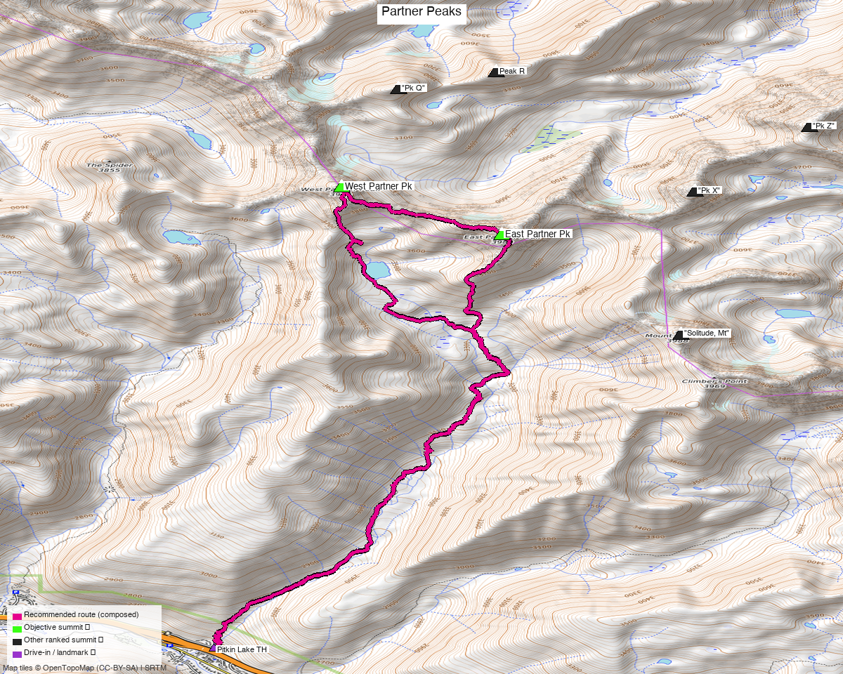
Note: the recommended route was distilled from 14 recorded GPS tracks of real trips (14ers.com · ListsofJohn · peakbagger) — all layered on the interactive CalTopo research map.
Peaks covered
Class 4 — East Partner's West Ridge, plus an awkward connecting traverse
climb13ers grades East Partner a solid Class 4 with moderate exposure (short sections), Difficult routefinding, loose "watch for falling mountains" rock, and notes detailed route beta is limited — "should only be attempted by experienced climbers/peakbaggers." An ice axe is recommended. West Partner is easier (Class 3) but the ridge between them is the crux of the day — see Route.
| Peak | Elev | Class (route) | Solo from TH (climb13ers) | peak_db |
|---|---|---|---|---|
| "West Partner Pk" | 13,058' | 3 (SE Face & Ridge) | 13.5 mi / 4,690' | 781 |
| "East Partner Pk" | 13,057' | 4 (West Ridge) | 14.4 mi / 5,010' | 768 |
Both sit in the Eagles Nest Wilderness (White River NF), Vail East quad — no permits/fees, standard wilderness rules. LiDAR added 17 ft to West Partner, making the twins effectively the same height (1 ft apart).
Getting there — Pitkin Creek (East Vail)
Drive from Boulder: ~2h 40m via Google Maps (origin: 1162 Peakview Circle) — I-70 W to East Vail (exit 180), then the frontage/Bighorn Rd to the Pitkin Creek trailhead parking.
| Trailhead — Pitkin Lake / Pitkin Creek | ~39.64288,-106.30318, ~8,430'. All paved, any passenger car (climb13ers confirms). Small lot wedged in an East Vail residential/condo area right off I-70 — it fills early on summer weekends. |
| Trail | Pitkin Creek Trail — ~4.5 mi and ~3,000' of well-built trail up to Pitkin Lake before any climbing. |
| Neighbors from the same TH | Pk Q, Pk X, Pk Z, Mt Solitude (their own reports) — this is the Pitkin Lake basin hub. |
Route — Pitkin Creek, East Partner first, then the traverse (Class 4)
~15.7 mi · ~5,380 ft round trip — the recommended line follows a September 2023 recording verbatim (a real party's both-peaks day; chosen for being summer, since the other both-Partners recordings are October shoulder-season):
- Pitkin Creek Trail from the trailhead — a long, well-graded ~4.5 mi grind up the drainage toward Pitkin Lake (~11,400'), the basin hub.
- East Partner via the West Ridge (crux, Class 4) — leave trail for boulder talus and stacked blocks; moderate exposure in short sections, difficult routefinding, loose rock. Beta is thin here, so expect to pick your own line and be comfortable committing to Class 4 moves.
- The traverse to West Partner — the day's real problem. climb13ers: staying high on the connecting ridge "may add as much as three hours"; you reduce the difficulty by dropping several hundred feet off the crest. The recorded route does exactly that — the line visibly drops into the basin and regains the ridge, which is why the pair goes in 15.7 mi instead of an all-day epic.
- West Partner (Class 3) — SE face and ridge: tundra, rubble and stacked boulders with minimal exposure and easy routefinding; a little easy Class 3 scrambling right at the top.
- Descend back into the Pitkin drainage and out the trail.
Order matters. Doing East first (harder, thinner beta) while fresh, then West on the way out, is what the recorded parties do and what the route reflects.
Gear & season
- Best window: mid-July through September — the Gores hold snow late and the north- facing Pitkin headwall holds it longest; climb13ers flags an ice axe for East Partner.
- Gear: helmet mandatory (loose Gore blocks, "falling mountains"); ice axe early season. No rope for the standard lines, but Class 4 downclimbing confidence is required — and the traverse rewards being willing to give up elevation rather than force the crest.
- Weather strategy: ~4.5 mi of trail before any exposure means a very early start; the Class 4 and the traverse are the slow parts, so be off the ridge before the afternoon monsoon builds.
- Cell: patchy — East Vail is close but the Pitkin basin is walled. Carry an InReach.
Other considerations
This is a long day for two 13ers. ~15.7 mi and ~5,380 ft, with the technical work all in the last third. Doing them separately is worse (13.5 mi and 14.4 mi respectively — you'd walk the same 9 mi of trail twice), which is exactly why every recorded party that gets both does them together.
The backpack alternative is legitimately attractive here. Pitkin Lake sits at the center of six ranked 13ers, and climb13ers explicitly recommends camping there. As day trips (your preference) the Partners are one outing and Q/X/Z/Solitude are others; as a backpack it's one trip for all six.
Parking is the practical constraint — a small East Vail lot with no overflow. Early start solves both this and the weather.
Trip reports & GPX (all three sources)
Sources confirmed logged in: 14ers.com ("Basin"), listsofjohn.com ("letsgocu"), peakbagger.com ("Kyle Knutson"). Both peaks' libraries were swept across all three sources and deduped, plus the full OSM trail network (60 mapped ways incl. Pitkin Lake, Booth Lake, Deluge Lake and Gore Creek trails) — all layered on the CalTopo map.
- 14ers.com: peak pages "West Partner Peak" (10246), "East Partner Peak" (10244) — 6 GPX-library tracks, including the September both-peaks day the route is built from.
- listsofjohn.com: "West Partner Peak" (781), "East Partner Peak" (768) — 10 trip reports, text only (probed the individual TR pages: no GPX links at all).
- peakbagger.com: West Partner pid 33057, East Partner pid 33058 — 3 ascent GPX pulled.
- climb13ers.com: West Partner SE Face & Ridge (Class 3) · East Partner West Ridge (Class 4, + the traverse warning) — route + TH beta.
Sources checked: 14ers.com ✓ (logged in, "Basin") · listsofjohn.com ✓ (logged in, "letsgocu") · peakbagger.com ✓ (logged in, "Kyle Knutson")