Star & Taylor Peaks: Taylor River NE Basin Circuit
Other climbers: Emily Sharpe — not yet · Shawn D Keil — ✓ all
At a glance — recommended day
9.5 mi · 4,979 ft gain · Class 2 · 2 peaks · ~6.12 h drive
NOAA weather link: Star & Taylor Peaks: Taylor River NE Basin Circuit Weather
Drive from Boulder: 6h 10m via Google Maps
CalTopo research map: https://caltopo.com/m/08L4HJN
Researched: 2026-09-09
Status in Peak Checklist: unclimbed. Both peaks sit at the dead end of the Taylor River road in a remote Elk Mountains basin — a genuine out-of-the-way objective that pairs two easy-to-moderate 13ers in a circuit most peakbaggers have not done.
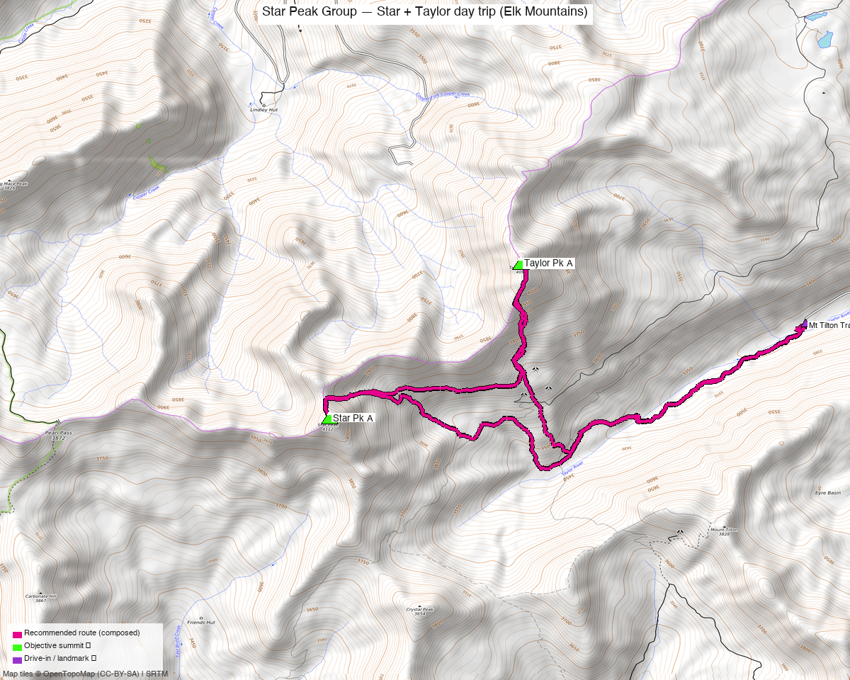
Note: the recommended route was distilled from 7 recorded GPS tracks of real trips (14ers.com · ListsofJohn · peakbagger) — all layered on the interactive CalTopo research map.
Peaks covered
Star Peak A (13,527', LoJ #240) and Taylor Peak A (13,438', LoJ #299) occupy the upper headwaters of the Taylor River in the Elk Mountains, on the Pearl Pass USGS quadrangle. The terrain falls within the Gunnison National Forest — no wilderness designation, no permit, no fee. The two peaks are the only ranked 13ers accessible from the Taylor River TH; the nearest other objectives (Pearl Mountain, Italian Mountain) require different drainages or much longer approaches. Access is as remote as it gets for the Elks: a long drive up valley to the literal end of the road at 10,780 ft, followed by a trailless approach through forest to open alpine terrain.
| Peak | Elev | Class | CO rank | Status |
|---|---|---|---|---|
| Taylor Peak A | 13,438' | 2 | 299 | unclimbed |
| Star Peak A | 13,527' | 2 | 241 | unclimbed |
Recommended route — Star + Taylor ⭐
9.5 mi · ~4,979 ft, Class 2+ — A circuit built around the NE basin bypass between the two peaks. The approach starts with a short bushwhack through forested slope (expect deadfall) before breaking out into open alpine country. Taylor Peak is a straightforward Class 2 tundra ridge walk; Star Peak adds the crux — descend off the connecting ridge at the ~12,800 ft decision point, cross a rock glacier basin, and scramble lichen-covered boulders to the top. Route-finding is rated moderate (climb13ers); the critical choice between the ridge traverse (unknown, potentially technical) and the basin bypass is settled in favor of the bypass. The single qualifying summer recording (johnkirk 2016, 10.7 mi RT) confirmed both summits from this TH and forms the composition base.
Route sequence
- Taylor River TH (10,780') — bushwhack NNW through forested slope, crossing deadfall, keeping the unnamed creek to your left. Cross FR761.1D (grade-3 4WD road running NE–SW across the basin) and follow a faint track a short distance to the ruins of an old cabin at ~11,480 ft.
- Cabin ruins → Taylor's NE ridge foot (~12,000') — continue NNW in open country on the west side of the stream course, roughly 3/4 mile from FR761.1D to the base of Taylor's broad NE ridge.
- NE ridge ascent → Taylor Peak A (13,438') — turn W/SW and ascend the moderately steep tundra ridge. The last few hundred feet below the summit transition from tundra to rock and rubble. No exposure, easy routefinding. Class 2. Strong parties 2.5 hrs from TH; allow 3–3.5 hrs otherwise.
- Decision point (~12,800') — from Taylor's summit, hike SSW along the ridge crest to about the 12,800 ft contour. Do not continue on the ridge (Option 1: rugged gendarmes, multiple elevation losses, and an unrated technical gash — climb13ers: "Good luck here. We have no idea how easy or difficult this section is"). Take Option 2 instead.
- NE basin bypass → Star Peak A (13,527') — descend S off the ridge ~400 ft on a tundra swath, then contour SW around a minor ridge and below cliffs into the large NE basin (a rock glacier). Cross the boulder field aiming for the saddle N of Star's summit. From the saddle, turn S and scramble lichen-covered boulders to the top. Minimal exposure, moderate routefinding. Class 2+. One-way from Taylor: ~1.75 mi / 1,225 ft gain (climb13ers).
- Return — descend Star's N ridge, drop E back into the rock glacier basin, and continue SE to tundra. Stay on the west side of the drainage and hike down through increasing trees to the Taylor River. Cross the creek (typically a manageable ford here) and pick up Forest Trail #582 back to the TH. Alternative return: after exiting the rock glacier basin, pick up FR761.1D and follow it as it contours between 11,600–11,800 ft back to the parking area.
Getting there — Taylor River TH (10,780')
| Drive from Boulder | 6h 10m via Google Maps |
| Trailhead | Taylor River TH, 38.98716, -106.75736, 10,780' |
| Road | Taylor River Road 740 (FR742): paved to Taylor Park Reservoir, then well-maintained graded gravel ~8 miles to Dorchester Campground, then ~5 miles of rougher unpaved road to the TH. OSM tags the final section surface=unpaved, smoothness=bad. climb13ers lists "Passenger Car" access (written 1998) but 4WD or high-clearance is strongly preferred for the last 5 miles. |
| Land | Gunnison National Forest — no wilderness designation, no permit, no fee. |
Gear & season
- Season: July through September. The single qualifying summer recording is September 2016 (johnkirk). The rock glacier approach to Star and the bushwhack through forest suggest snowmelt is needed — mid-July is a reasonable earliest target in a normal year; September is confirmed good.
- Ice axe: climb13ers recommends one, likely for early-season snow lingering on the rock glacier and upper slopes. After mid-July in a typical year it is probably not needed, but check conditions.
- Terrain: mostly tundra and open alpine; the rock glacier crossing involves large boulder talus. The final push to Star is lichen-covered boulders — wet rock is notoriously slick here (climb13ers notes a rainy ascent made them "banana-peel slick").
- Approach: the forest bushwhack from the TH is short but involves deadfall — gaiters help.
- Storms: standard Elk Mountains pattern; plan to be off summits by noon or early afternoon.
- Cell coverage: likely minimal to none in the upper Taylor River basin. Download offline maps before leaving Gunnison.
Other considerations
Drive time: At 6h 10m from Boulder this is one of the longer drives in the queue — on par with deep San Juan objectives. The Taylor River TH has camping right at the road end and numerous Forest Service campgrounds along the valley, making a basecamp approach sensible for combining multiple objectives over 2–3 days.
Same-drainage candidates: Pearl Mountain (13,379', Class 2) and "Oyster Peak" (13,316', Class 2) sit ~2–3.7 mi WSW of Star in the Taylor River drainage and appear combinable in a longer traverse day. No GPX tracks in the current pool cover them from this TH, so that linkup is unconfirmed. Pearl + Oyster already have their own report (peaks/pearl_oyster.md, Castle Creek TH); check whether they share any approach with this TH before assuming a linkup.
Nearby objectives from different TH: Italian Mountain (13,385') and Malemute Peak (13,318') start from a different drainage cluster to the south. Keefe Peak, Hunter Peak, Hilliard Peak, and Triangle Peak (Conundrum Creek / Brush Creek area) are 5–8 mi from Star and would require a different base.
Taylor-only option: If only Taylor Peak is the objective, that is a clean 4 mi RT / 2,665 ft at Class 2 — climb13ers calls it a "medium day / take a lunch" and rates it 3/5 stars for families (with older kids). Star adds ~1.75 mi and 1,225 ft one-way beyond Taylor's summit; the full circuit is the better use of the long drive.
Direct ridge traverse (Option 1) — do not use: The connecting ridge from Taylor to Star is described by climb13ers as having "rugged gendarmes" and a "jumbled mass of rocky spires and outcrops, followed by a deep gash" with unknown difficulty. It has not been graded and should be treated as potentially Class 3+ or harder. The NE basin bypass (Option 2) is the documented, recommended line and the one this route is built on.
Trip reports & GPX (all three sources)
Sources confirmed logged in: 14ers.com ("Basin"), listsofjohn.com ("letsgocu"), peakbagger.com ("Kyle Knutson"). All three swept fresh for this build, plus the mapped OSM trails in the bbox — all layered on the research map.
-
14ers.com: 2 track(s) harvested (+1 duplicate(s) of another source). Pages exist for both peaks (ids 10099 and 10104). Two tracks swept:
trk_14ers_1(summer 2023, one-way, Taylor only, disqualified — crosses West Tellurium) and14ersGPXlib_72823(winter, Nov 2020, disqualified). -
listsofjohn.com: 3 track(s) harvested (+3 duplicate(s) of another source). LoJ pages: Star Peak A (id 301), Taylor Peak A (id 365). Three tracks swept:
johnkirk_2016_loj7235(summer 2016, 10.7 mi RT — the only qualifying full-coverage summer recording and the composition base),josephnephi_2024_loj26881(shoulder 2024, disqualified — crosses Italian Mountain, one-way),whileyh_2020_loj17731(winter Nov 2020, disqualified). -
peakbagger.com: 2 track(s) harvested (+2 duplicate(s) of another source). PB pages: Star Peak A (pid 14666), Taylor Peak A (pid 15740). Two tracks swept:
pb_Star_aid1533069(winter Nov 2020, disqualified) andpb_Italian_aid1678921(shoulder 2021, disqualified — starts from Italian Mountain cluster ~7 mi south and crosses Italian Mountain).
Sources checked: 14ers.com ✓ (logged in, "Basin") · listsofjohn.com ✓ (logged in, "letsgocu") · peakbagger.com ✓ (logged in, "Kyle Knutson")