Kendall Mtn + Kendall Pk + Mountaineer + PT 13,117 + PT 13,073 — five in a day from Silverton (Class 2)
Other climbers: Emily Sharpe — not yet · Shawn D Keil — not yet
At a glance — recommended day
15.8 mi · 6,166 ft gain · Class 2 · 5 peaks · ~8.49 h drive
NOAA weather link: Silverton Weather
CalTopo research map: https://caltopo.com/m/HPHRSPV
Researched: 2026-08-01
Status in Peak Checklist: all five unclimbed.
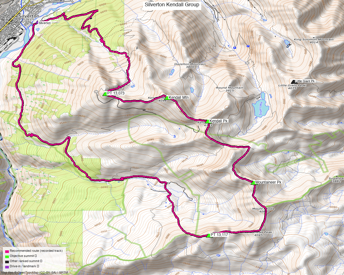
Note: the recommended route was distilled from 27 recorded GPS tracks of real trips (14ers.com · ListsofJohn · peakbagger) — all layered on the interactive CalTopo research map.
Five peaks, one day, straight out of town
This started as six unclimbed summits on the ridge above Silverton. Five of them link into one round trip; the sixth does not. Little Giant Peak sits in a different drainage (Arrastra Gulch) and every recording reaches it from there — composing all six together produced a 27 mi line with three separate 100% retraces. Little Giant has its own report; this one is the five that genuinely go together.
| Peak | Elev | Class | Note |
|---|---|---|---|
| Kendall Pk | 13,455' | 2 | |
| "Mountaineer Pk" | 13,441' | 2 | unlabelled on most maps |
| Kendall Mtn | 13,353' | 2 | |
| PT 13,117 | 13,117' | 2 | |
| PT 13,073 | 13,073' | 1+ | LoJ calls it "Kendall No 2 Benchmark" |
San Juan County — San Juan National Forest, the ridge east of Silverton.
Two labelled summits here are NOT objectives
Mount Rhoda (13,418') and Whitehead Peak (13,276') appear prominently on the topo, and both sit directly on this ridge. Neither is ranked — 297 ft and 139 ft of prominence, below the 300 ft cut — so neither counts toward the list. Both are essentially free if you are passing anyway, and the recorded parties do tag them.
Conversely, the two summits with the least obvious names on the map — the unlabelled western and central triangles — are real ranked objectives: Kendall No 2 Benchmark and "Mountaineer Pk".
The recommended route — 15.8 mi / 6,166 ft
trk_14ers_4 ridden verbatim: one party's clean round trip over all five, September 2024,
with a 0.02 mi maximum point gap. It starts and ends in Silverton itself.
Composing was evaluated and lost badly. compose_best_route proposed 22.12 mi — 6.3 mi
worse — and bought that with three separate 100% retraces, shuttling back and forth along the
same ridge because no pair of recordings offers a genuinely distinct return. Two of its legs also
ended 323 ft off their anchors. One party's real loop beats a stitched one here.
The 4WD shortcut, and why it is not the published line
trk_14ers_2 tours the same five summits in 15.1 mi — 0.7 mi shorter — but starts at
10,847 ft up Kendall Mountain Road, 1,550 ft above town. It is also a June shoulder
recording with a 0.17 mi (900 ft) internal point gap, the weakest track in the pool.
Trading the honest town start for 0.7 mi, on the strength of the least reliable recording, is a bad deal. Drive Kendall Mountain Road if you like — it is a real option and it removes a long road grind — but the figures here assume you did not.
Getting there
| Drive from Boulder | ~8h 30m via Google Maps |
| Trailhead | Silverton, 37.81140, −107.65786, 9,297' — you park in town. No trailhead facility; OSM maps no highway=trailhead node anywhere in this basin. |
| Roads | CR 2 out of town is asphalt then compacted; CR 21 and CR 22 are gravel at tracktype=grade2. Kendall Mountain Road, if you take it, is the rough one. |
| Land | San Juan NF. The access sweep found three access=private parcels plus the Kendall Mountain Recreation Area and Silverton Mountain ski areas in the wider box; none touch the route. |
Gear & season
- Best window: July through September.
- Terrain: Class 2 throughout, and Class 1+ on Kendall No 2 Benchmark — this is the gentlest grade of any multi-peak report on the site. The difficulty here is distance and 6,166 ft of gain, not the ground.
- Variant to know about: one party took a Class 2+/3 ridge line onto Kendall Peak and called it "fun". That is a deliberate harder choice, not the recorded route.
- Storms: most of the day is on an open ridge above treeline — early start.
Other considerations
Little Giant Peak is the natural second day. It is 8.4 mi from Arrastra Gulch, 20 minutes further up the same road out of Silverton. Two days, six peaks, one 8.5-hour drive.
Trip reports & GPX (all three sources)
All three sources swept across all five objective peaks and deduped, plus the mapped OSM trail network — all layered on the research map.
- 14ers.com: peaks 10439, 10400, 10578, 10405, 10557 — 11 GPX-library tracks.
- listsofjohn.com: peaks 452, 358, 754, 367, 704 — 2 tracks from 25 trip reports (plus 4 duplicates). LoJ cross-verified the peakbagger ids: 15980 / 16064 / 15161 / 15940 / 15020.
- peakbagger.com: peaks 15980, 16064, 15161, 15940, 15020 — 14 ascent tracks with GPS (plus 14 duplicates).
Sources checked: 14ers.com ✓ · listsofjohn.com ✓ · peakbagger.com ✓