Imogene Pass Group — six 13ers from a 13,116' park (Class 3)
Other climbers: Emily Sharpe — not yet · Shawn D Keil — 3 of 6 (Telluride Pk, T 7, Hayden Mtn South)
At a glance — recommended day
11.43 mi · 5,033 ft gain · Class 3 · 6 peaks · ~9.84 h drive
NOAA weather link: Imogene Pass Group Weather
CalTopo research map: https://caltopo.com/m/JC8SGE7
Researched: 2026-07-29
Status in Peak Checklist: all six unclimbed. The whole point of this trip is the trailhead elevation: a mapped dirt parking area on Imogene Pass Rd at 13,116', which is above the summits' saddles and only 0.5 mi from Telluride Peak. Six ranked 13ers come within reach of one push that would cost an enormous day from any paved trailhead.
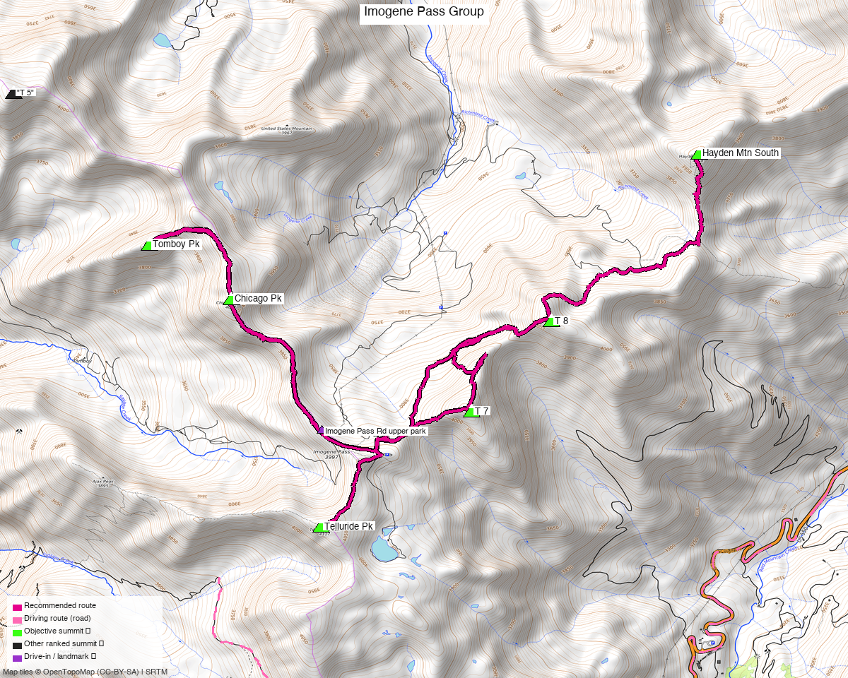
Note: the recommended route was distilled from 30 recorded GPS tracks of real trips (14ers.com · ListsofJohn · peakbagger) — all layered on the interactive CalTopo research map.
Peaks covered
Six unclimbed ranked 13ers in the San Juan Mountains, on the ridge system radiating from Imogene Pass between Telluride and Ouray.
| Peak | Elev | Class | CO rank | Status |
|---|---|---|---|---|
| Telluride Pk | 13,514' | 2 | 245 | unclimbed |
| Chicago Pk | 13,391' | 2 | 326 | unclimbed |
| "T 7" | 13,360' | 2 | 351 | unclimbed |
| "T 8" | 13,315' | 2–3 crux | 385 | unclimbed |
| Hayden Mtn South | 13,211' (LiDAR) | 2 | 483 | unclimbed |
| "Tomboy Pk" | 13,101' | 2 | 569 | unclimbed |
Ouray and San Miguel counties, Ironton and Telluride quads — Uncompahgre NF. No permits or fees. This is old mining country: expect adits, shafts and ruins near the route.
peak_db's summit coordinates were wrong for three of these
Located from track convergence and checked against contour crops before use:
- T 8 — marker was 308 ft off and 43 ft low (7 tracks)
- T 7 — 154 ft off, 39 ft low (8 tracks)
- Telluride Pk — 63 ft off, 22 ft low (7 tracks)
All three are corrected here and on the CalTopo map. If you have an older GPX of these peaks from the same source, its waypoints are off by those amounts.
Recommended route — the pass ridge, out to Hayden and back ⭐
~11.4 mi · ~5,030 ft round trip, Class 3, from the Imogene Pass Rd upper parking (13,116').
Route sequence
- From the parking, head north up the ridge to Chicago Pk (13,391') — climb13ers: from the pass this goes "easily."
- Continue northwest to Tomboy Pk (13,101'), the low point of the day in elevation and the only one of the six with no published route description anywhere.
- Return past the parking and head east to "T 7" (13,360').
- "T 7" → "T 8" is the crux. Drop onto the north side to bypass the saddle. Staying on the crest runs into rock towers and Class 3–4 ground (see below).
- From "T 8" (13,315'), follow the ridge northeast 1.8 mi to Hayden Mtn South (13,211').
- Reverse that spur back over "T 8" — it is the only recorded way back.
- Finish south on Telluride Pk (13,514'), the high point of the day, which sits 0.5 mi from the car and 370 ft above it — an easy walk-off to close.
The T 7 → T 8 saddle is the one place to be careful
climb13ers is precise about it: "From T.7, T.8 is a Class 2–3 ridge traverse if the saddle section is avoided by dropping down on the north side of the ridge. Remaining on the ridge crest will lead to Class 3–4 work because of some rock towers that block the way." Exposure is rated moderate in short sections — the only place on the day it is not "none."
Take the north-side bypass. If you find yourself scrambling on towers, you have missed it.
One honest gap in the beta. The 1.8 mi ridge from "T 8" to Hayden Mtn South is walked by the recorded tracks this route is built from, but no source publishes a grade for it. Hayden Mtn South itself is Class 2 with no exposure (climb13ers' Full Moon Gulch route), and climb13ers' "difficult and extended ridge" warning applies to Hayden South → Hayden North, which this route does not touch. Treat the link as unverified Class 2–3 and budget time for routefinding.
Why the route retraces the Hayden spur. No recorded track connects Hayden Mtn South back to the pass any other way, and inventing a connector is not something this project does. The out-and-back adds 1.8 mi; the alternative is a car shuttle to US 550.
Getting there — Imogene Pass Rd upper parking (13,116')
| Drive from Boulder | ~9h 55m via Google Maps |
| Trailhead | 37.93228, −107.73611, 13,116' — OSM parking way/1194872479, surface=dirt, access=yes. Three recorded tracks start within 0.05 mi. |
| Road | Imogene Pass Rd: 4wd_only=yes, smoothness=horrible, tracktype=grade3. This is the gate on the whole plan. |
| Land | Uncompahgre NF — no permits/fees. Historic mining district; stay out of adits and off private mine claims. |
The drive is the cost of the high start. By road the two realistic trailheads compare like this
(drive_matrix.py, OSRM — which over-weights rough roads, so treat as an upper bound):
| Trailhead | Drive from home | Distance |
|---|---|---|
| Imogene Pass Rd upper parking (13,116') | ~9h 35m | 371 mi |
| Idarado Mine pullout, US 550 (9,958') | ~7h 50m | 361 mi |
They are only 11.1 mi apart but ~2h of that by road — the Imogene Pass road itself. So the high park buys 3,158 ft of elevation for roughly 1.5–2 h of extra slow driving. Given six peaks, that trade is strongly worth it; for one or two peaks it would not be.
Gear & season
- Best window: July through September. Four swept tracks are winter/spring lines (2017-05, 2025-05, 2018-04, and a January Hayden ascent) — not the basis of this route.
- Terrain: Class 3 headline, but only at the T 7 → T 8 saddle. Everything else is Class 2 ridge walking on tundra and broken rock. Helmet worth carrying for the saddle.
- Altitude: you start at 13,116' and stay high all day — there is no acclimatisation ramp. Sleep high the night before if you can.
- Storms: the entire day is above treeline with no bail-out below the ridge except back to the road. Start at first light and be off the ridge early.
- The vehicle is the crux of the trip, not the peaks. If the road turns you back, the day does not exist — have the Idarado plan (below) as a fallback.
- Cell: patchy; carry an InReach.
Other considerations
This overlaps an existing report, deliberately. Telluride Peak Group covers Telluride Pk + "T 7" + "T 8" from the Idarado Mine pullout on US 550 — a paved, passenger-car trailhead, 10.1 mi and 6,057 ft for three peaks. Keep both: that report is the right answer when the 4×4 road is out (snow, a closure, a different vehicle), and it needs no 4WD at all. This report is the right answer when you can drive high and want six.
What was deliberately left out. Trico Pk and T 10 sit on the southern arm from the pass. Chasing them is what forces the long traverse over La Junta Pk and PT 13,145 A — both already climbed — and pushes the day to 19+ mi with 7,500 ft. Dropped by choice.
Do not overrun onto Hayden Mtn North (1.17 mi past Hayden South) — already climbed, and climb13ers calls the ridge between them "difficult and extended," requiring a drop into the Fall Creek headwaters to keep it Class 2.
Still unclimbed nearby if the day goes well: "King and Three Queens" (0.66 mi from Hayden South), "Richmond Peak" (0.77 mi), United States Mountain (2.01 mi). None are researched here.
Trip reports & GPX (all three sources)
Sources confirmed logged in: 14ers.com ("letsgocu"), listsofjohn.com, peakbagger.com. All six peaks' libraries swept and deduped — 30 unique recorded tracks plus 346 mapped OSM trails in the basin, all on the research map.
- listsofjohn.com: peaks 311 · 407 · 434 · 472 · 724 · 601 — 15 tracks from 54 trip reports. TR gpx 2288 (2016-07) is the backbone of this route: it starts 249 ft from the parking and links five of the six. TR gpx 13307 supplies the "T 8" ↔ Hayden Mtn South spur.
- 14ers.com: peaks 10375 · 10426 · 10434 · 10449 · 10565 · 10506 — 5 unique tracks (4 more were duplicates of LoJ/pb copies). One GPX-library track appears on six of the peaks — a single link-up day.
- peakbagger.com: peaks 14672 · 19634 · 64570 · 64568 · 84931 · 60361 — 10 unique GPS ascents, the widest coverage of the three. All six pids cross-checked against LoJ's links.
- climb13ers.com: Telluride Pk · T 7 · T 8 · Chicago Pk · Hayden Mtn South — the source of the T 7 → T 8 crux description. "Tomboy Pk" has no climb13ers page (404), so its only beta is peak_db, LoJ and the recorded tracks.
Sources checked: 14ers.com ✓ (logged in, "letsgocu") · listsofjohn.com ✓ (logged in) · peakbagger.com ✓ (logged in) · climb13ers.com ✓ (5 of 6 peaks; Tomboy not covered)