Other climbers: Emily Sharpe — not yet · Shawn D Keil — 1 of 2 (Broken Hand Peak)
Crestolita + Broken Hand Peak — combination day (Sangre de Cristo)
At a glance — recommended day
11.7 mi · 4,706 ft gain · Class 3 · 2 peaks · ~4 h drive
NOAA weather link: Crestolita + Broken Hand Peak Weather
Drive from Boulder: 3h 58m via Google Maps
CalTopo research map: https://caltopo.com/m/H71NCN0
Researched: 2026-05-31 · route, trailhead and access rebuilt from scratch 2026-08-04
Status in Peak Checklist: Both 0 ascents (unclimbed). Crestone group context: Crestone Peak, Crestone Needle, and Humboldt Peak are all ✓ done — these two are the remaining ranked satellites of the South Colony / Cottonwood cirque.
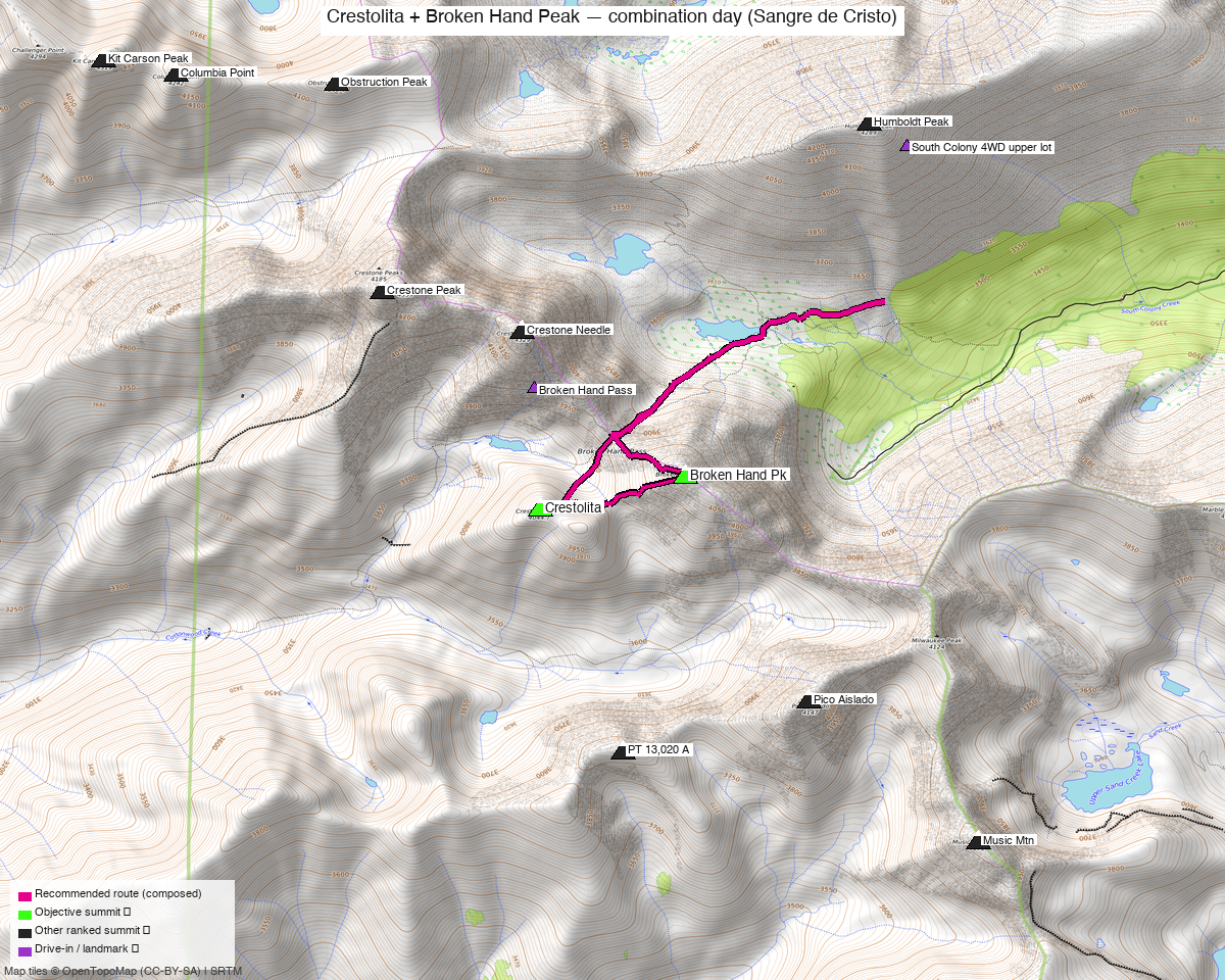
Note: the recommended route was distilled from 17 recorded GPS tracks of real trips (14ers.com · ListsofJohn · peakbagger) — all layered on the interactive CalTopo research map.
Peaks covered
| Broken Hand Peak | "Crestolita" | |
|---|---|---|
| Elevation (LiDAR) | 13,575' | 13,264' |
| Lat / Lon | 37.95671, −105.56665 | 37.9549, −105.57561 |
| Class (standard) | 3 | 2 (south face) |
| CO Rank | 205 | 431 |
| Prominence (LiDAR) | 649' | — |
| Range / Wilderness | Sangre de Cristo / Sangre de Cristo Wilderness | same |
| County | Custer & Saguache | Custer & Saguache |
| 14ers.com peak page | 10629 | 10665 |
| LoJ peak page | 258 | 524 |
| peakbagger | pid 5910 | pid 32622 |
| Peak DB id | 258 | 524 |
The two summits are 0.6 mi apart along the ridge SW of Crestone Needle — a natural, well-established pairing.
Why these two together: this is a standard combination, not a forced pairing. Of the trip reports that hit either peak, the majority do both in one outing:
- whileyh (2025-06-11) — Crestolita + Broken Hand, the cleanest example of the exact combo
- Alyson Kirk (2014-08-21) — Crestolita + Broken Hand
- Furthermore / Derek Wolfe (2011-04-16) — Crestolita + Broken Hand (winter)
- Marmot72 "Broken Hand Wrap Up" (2023-08-19) — both, finishing the Sangres 13ers
- josephnephi (2025-09-06) — both as part of the full Crestone-group mega-day (Crestone Peak E/W + NE Crestone + Needle + Broken Hand + Crestolita)
- supranihilest "Crest of Spring" (2023-05-06) — both via snow couloirs
Combos (ranked 13er+ rule): Each counts as a true ranked-partner combo for the other (13,575' and 13,264', both ranked). The wider Crestone group (Peak/Needle/Humboldt) is already done, so this pairing is the efficient way to clean up what's left in the cirque in a single approach.
Recommended plan — South Colony Lakes approach ⭐
The closer, more efficient approach for the pair (Marmot72 chose it over Cottonwood explicitly). Both peaks sit on the ridge above the South Colony basin, reached via Broken Hand Pass (the same saddle used on the standard Crestone Needle route).
11.7 mi / 4,706 ft, composed from five recordings so each stretch of the day is the best recorded version of itself rather than one party's whole outing.
Take Crestolita first. That is not a preference, it is what every South Colony–side party
does: 23274, 62587 and 22067 all record Crestolita → Broken Hand Pk, in that order.
Only the parties coming over from Crestone on the west do it the other way, because they arrive
from the far side.
The reason is the shape of Crestolita. Its easy line is the south face — supranihilest: "the easiest route is the Class 2 south face." So the day swings south and west below the crest to get onto that face, tops out on Crestolita, then takes the short link northeast to Broken Hand. The deep-looking loop on the map is that approach, not a detour between the summits.
As drawn, the day returns the way it came, re-crossing the link between the two summits. See Other considerations — descending into the basin instead is very likely the better exit, and the route optimiser cannot choose it because it scores effort and never difficulty.
Shorter recorded numbers are not your day. The 7.1 mi and 7.9 mi tracks start 1,695 and
2,288 ft above the trailhead, up a road OSM tags access=forestry. Quoting them is how the
previous version of this report published 3.8 miles for a pair that takes nearly twelve.
This is a big day — plan it as a full alpine outing, not a half-day.
Route sequence (South Colony → Crestolita → Broken Hand → back over the pass)
- From the South Colony 4WD Trailhead (9,897'), follow the South Colony Lakes trail toward the lakes / Crestone Needle junction
- Ascend toward Broken Hand Pass (~12,900'), the saddle between Crestone Needle and Broken Hand Peak
- Crestolita (13,264', Class 2) first. Contour south and west below the crest to get onto its south face / summit gully, the easy side of the peak. This is the part of the day that looks like a big loop on the map — it is buying you the Class 2 line instead of the crest.
- Broken Hand Peak (13,575', Class 3): the short link northeast from Crestolita, then the standard Class 3 line to the summit (NW/west side — not the south ridge, which is the 4th–low-5th "Analemma/South Ridge" and a hard technical variant; see Other considerations)
- Return over Broken Hand Pass to the South Colony trail and the trailhead — or, better, drop into the basin below the summits and regain the pass low (see Other considerations).
Honest caveat: the cleanest easy-class way to bag both may actually be from Cottonwood Creek (full reasoning in Other considerations).
Crestolita route notes
- Easiest line: supranihilest — "the easiest route is the Class 2 south face from Cottonwood Creek (the approach is harder than the climb of the peak)." There's also a south-facing summit gully that reportedly goes Class 2 from the Broken Hand Pass side.
- NE couloir / north couloirs: moderate snow lines into early summer (Furthermore April, supranihilest May) — axe/crampons, couloir experience. Easy to spot conditions from Broken Hand Pass.
Getting there — drive + approach
| Drive from Boulder | 3h 58m via Google Maps (199 mi, origin: 1162 Peakview Circle) |
| Primary trailhead | South Colony 4WD Trailhead — 37.97642, −105.50547, 9,897'. Mapped parking, no fee. Six recorded tracks start within 0.11 mi; the recommended route begins 65 ft away. |
| 4WD continuation | South Colony Road continues ~2.5 mi of rough road toward an upper lot (~11,000'), and Marmot72 took a stock '18 Subaru Forester to ~¼ mi below it. But OSM tags that stretch access=forestry, so treat driving it as unconfirmed rather than a right — and note the 12.4 mi assumes you did not. Every mile you drive up is a mile off the day; that is exactly how the short recorded tracks got short. |
| Alternate trailhead | Cottonwood Creek (longer, rougher approach from the Crestone/west side) — preferred only for the Crestolita south face as a standalone or for the north couloirs |
Gear & season
- Best window: mid-June through September for the standard Class 2–3 lines (snow lingers in the couloirs and on N aspects into early summer)
- Snow season: the north couloirs on Crestolita are a legitimate spring objective (Furthermore April, supranihilest May) — bring axe/crampons and couloir experience
- Rock: Sangres conglomerate — the Crestone-group rock is famously grippy when dry, but loose blocks exist; Broken Hand is a true Class 3 scramble
- Storms: standard Sangres afternoon storm risk on exposed ridge — early start, off the ridge by early afternoon
- South Colony fatalities note: Marmot72 references multiple historic SAR/fatality incidents at South Colony over the years — the Crestone group terrain is unforgiving; respect the Class 3+ exposure
- Permits / access: Sangre de Cristo Wilderness — no permits required. Rio Grande / San Isabel National Forest — no fee. South Colony Road: 2WD to the lower lot; high-clearance 4WD for the upper ~2.5 mi (drivable in a careful stock AWD per Marmot72)
- Cell coverage: 14ers.com community DB has 0 reports for both Broken Hand Peak and Crestolita (consistent with the broader Sangre de Cristo gap). South Colony TH / approach: likely dead — the trailhead and lower basin sit deep on the east side of the range, topographically shadowed from the San Luis Valley towers. Broken Hand Pass / summits: possible signal on the high points — line-of-sight west toward the San Luis Valley (Crestone/Moffat); don't count on it. Carry an InReach / satellite messenger — community data is nonexistent here and the terrain is committing (especially the technical traverse, which has no bail).
Other considerations
Consider descending into the basin instead of reversing the traverse ⭐
The recommended line above is an out-and-back: it crosses the Broken Hand ↔ Crestolita link twice. That is what the recorded tracks support, and it is how the route composes on distance and gain — but it is probably not the best day.
Once you have both summits, the second crossing of that link buys nothing and is where the difficulty sits. The better shape is almost certainly: take both peaks, then drop off into the basin and regain Broken Hand Pass low on the way out, rather than re-crossing the connecting ground and going back over Broken Hand.
This is not in the drawn line because the route optimiser scores distance, gain and how much of the day is on trail — it has no notion of difficulty, so a shorter reversal always beats a longer descent in its arithmetic even when the reversal is the harder and more exposed option. Judge it on the ground: if the basin below the summits is holding reasonable footing, taking it is very likely the better exit.
Alternate — Cottonwood Creek approach
The cleanest easy-class way to bag both may actually be from Cottonwood Creek, where each peak has a Class 2 south side and you skip the Broken Hand Pass elevation — at the cost of a longer, rougher approach (per Marmot72). From South Colony you get a shorter approach but the link between the two involves descending/contouring, not a simple ridge walk. Cottonwood makes sense mainly if:
- You want Crestolita's Class 2 south face as the most direct line on that peak
- You're chasing the north couloirs for a snow climb (supranihilest, Furthermore did winter/spring lines here)
- You're approaching from the Crestone (west) side of the range
For the efficient two-peak day, South Colony is the better base.
Technical alternate — Analemma (NE Ridge) + South Ridge of Broken Hand 🪨
For scramblers, the classic hard linkup of these two is a separate, far more serious objective (TR 23274):
| Route | Analemma (Crestolita NE Ridge) + South Ridge of Broken Hand Peak |
| Stats | ~12 mi, ~5,700' (Broken Hand Pass approach) |
| Class | 5.easy (4th class to low-5th along Broken Hand's gendarmes) |
| Exposure | Extreme · Rockfall High (NE couloir descent) · Commitment Extreme |
| Bail | None once on the ridges/gendarmes — "you are committed, especially not to the East" |
| Season | Later summer (once Crestolita's NE couloir melts out) |
This is one of the range's premier non-standard scrambles on excellent conglomerate, but it is not the way to simply tick both summits — it's a committing 5th-class day. Only relevant if you specifically want the scramble.
Trip reports & GPX (all three sources)
listsofjohn.com
| Date | Author | Peaks | GPX |
|---|---|---|---|
| 2025-06-11 | whileyh | Crestolita + Broken Hand | 17727 ⭐ exact combo |
| 2014-08-21 | Alyson Kirk | Crestolita + Broken Hand | 1075 |
| 2025-09-06 | josephnephi | Full Crestone group incl. both | 18129 |
| 2011-04-16 | Furthermore | Crestolita + Broken Hand (winter) | — |
| 2020-07-29 | Bob Burd | Crestone-to-Milwaukee traverse incl. both | — |
14ers.com (21 Broken Hand TRs / 11 Crestolita TRs; 9 + 5 GPX library files)
| Trip | Author | Notes |
|---|---|---|
| 22287 | Marmot72 | "Broken Hand Wrap Up" — both, South Colony approach, road/driving beta |
| 22067 | supranihilest | "Crest of Spring" — both via north couloirs (snow) |
| 23274 | — | "Analemma and the South Ridge of BHP" — both, south ridge line |
| 18794 | — | "Crestones via Cottonwood Creek" — both, Cottonwood approach |
peakbagger.com (logged in as Kyle Knutson)
8 ascent GPX tracks pulled — Broken Hand (pid 5910): 5 of 6 ascents had GPX; Crestolita (pid 32622): 3 of 3 ascents had GPX.
GPX collected: 21 track files across all three sources (LoJ + 14ers TR uploads + 14ers GPX library + peakbagger ascents) — all layered on the CalTopo research map.
Sources checked: 14ers.com ✓ (logged in, "Basin") · listsofjohn.com ✓ (logged in, "letsgocu") · peakbagger.com ✓ (logged in, "Kyle Knutson")