Other climbers: Emily Sharpe — not yet · Shawn D Keil — 1 of 2 (Fairview Peak A)
Gold Basin Trip — Fairview Peak + Henry Mountain (car-camp)
At a glance — 2-day trip
2 peaks · ~5.5 h drive
- Day 1 (Fairview Pk A): 2.8 mi · 1,137 ft gain · Class 1 · 1 peak
- Day 2 (Henry Mtn (Gunsight Pass)): 9.3 mi · 3,666 ft gain · Class 2 · 1 peak
NOAA weather link: Gold Basin Weather
Drive from Boulder: ~5h 30m via Google Maps
CalTopo research map: https://caltopo.com/m/510FM45
Researched: 2026-07-22
Status in Peak Checklist: both unclimbed. Two ranked Gunnison 13ers in the Gold Creek / Gold Basin system — packaged as one car-camp trip because they're ~5.5 h from home and share the drive; doing them as two separate round-trips would double an 11-hour haul. Per-peak detail: Fairview Peak · Henry Mountain.
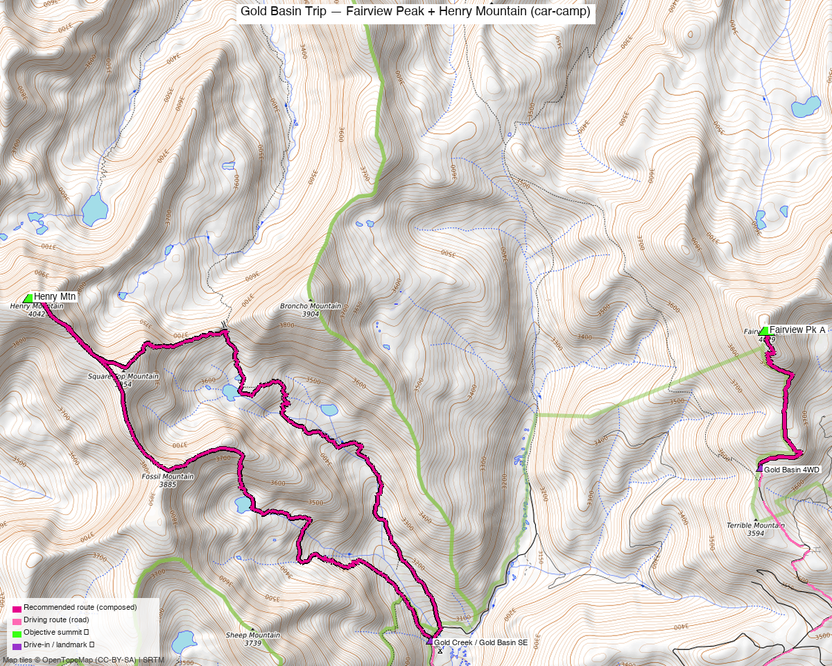
Note: the recommended route was distilled from 14 recorded GPS tracks of real trips (14ers.com · ListsofJohn · peakbagger) — all layered on the interactive CalTopo research map.
Peaks covered
A relaxed car-camp weekend based in Gold Basin: an easy Class 1 half-day (Fairview) and a moderate Class 2 day (Henry via Gunsight Pass), each from its own trailhead a short drive apart. Hardest move on the trip is Class 2.
| Peak | Day | Elev | Route | Class | CO rank |
|---|---|---|---|---|---|
| Fairview Pk A | 1 | 13,224' | Gold Basin walk-up (upper 4WD) | 1 | #465 |
| Henry Mtn | 2 | 13,272' | Gold Creek → Gunsight Pass | 2 | #424 |
Itinerary options
Option A — car-camp weekend (recommended): the day list in At a glance. Drive in, camp in Gold Basin, take the short easy Fairview the first afternoon (or as a warm-up), then the longer Henry on a full day. Reverse if you'd rather do the big day first while fresh.
Option B — both in one long day: a strong, early party can drive between the two trailheads and bag both (~12 mi combined, Class 2). Feasible given the short relocation, but the car-camp split is the sane call for a peak this far from home — you've already paid the drive, so there's no reason to rush.
Getting there — Gold Creek Rd (FR 771)
| Drive from Boulder | ~5h 30m via Google Maps — via US-285 / US-50 to Gunnison, then Gold Creek Rd (FR 771) into the Gold Basin / Gold Creek area. |
| Fairview TH | Upper Gold Basin, ~12,030' — a rough high-clearance / 4WD spur; park where your rig tops out (drive-higher/lower options in the Fairview report). |
| Henry TH | Gold Creek / Gold Basin SE, ~10,060' — the more accessible of the two. |
| Relocation | The two trailheads are a short drive apart on the FR 771 system — the black line on the map is the connecting road. |
| Land | GMUG NF — no permits/fees; not designated wilderness. |
The days, in order
Day 1 — Fairview Peak (Class 1)
From the upper Gold Basin 4WD start (~12,030'), a short tundra walk north to the broad summit — ~2.8 mi / ~1,140 ft, no scrambling. An easy leg-stretcher after the long drive. Full detail: Fairview Peak report.
Day 2 — Henry Mountain (Class 2)
From the Gold Creek / Gold Basin SE TH (~10,060'), up the Gold Creek drainage over Gunsight Pass (~12,100') and into Henry's upper basin — ~9.3 mi / ~3,670 ft, Class 2 tundra and talus. The bigger of the two days. Full detail: Henry Mountain report.
Camps & water
- Car camping: dispersed sites are common along Gold Creek Rd (FR 771) and near the Gold Creek trailhead/campground — base here between the two peaks. No developed hookups; pack it in/out.
- Water: Gold Creek and its tributaries run through the basin (treat); the upper Gold Basin 4WD spur (Fairview side) is drier up high — carry from camp.
Gear & season
- Best window: July–September — the Gold Basin roads melt out late and the higher basins hold snow into early summer.
- Vehicle: high-clearance / 4WD helps on FR 771, and is effectively required for the high Fairview start; Henry's TH is more forgiving.
- Terrain: Class 1 (Fairview) and Class 2 (Henry) — no scrambling; the work is distance, altitude, and the drive.
- Storms: both days spend time above treeline (Henry more so, over Gunsight Pass) — early starts, off the high ground by early afternoon.
- Cell: unreliable throughout the Gold Basin / Gold Creek drainages — carry an InReach.
Trip reports & GPX (all three sources swept)
Sources confirmed logged in: 14ers.com ("Basin"), listsofjohn.com ("letsgocu"), peakbagger.com ("Kyle Knutson"). Both peaks' libraries swept across all three sources and layered on the research map — the two composed day routes in magenta, the connecting road dashed black. Per-peak trip-report and GPX detail lives in the individual reports: Fairview · Henry.
Sources checked: 14ers.com · listsofjohn.com · peakbagger.com · climb13ers.com