Bridal Peak + PT 13,145 — a Columbine Lake loop above Ophir (Class 2+)
Other climbers: Emily Sharpe — not yet · Shawn D Keil — ✓ all
At a glance — recommended day
8.7 mi · 3,477 ft gain · Class 2+ · 2 peaks · ~8.44 h drive
NOAA weather link: Ophir / Columbine Lake Weather
CalTopo research map: https://caltopo.com/m/ETM100L
Researched: 2026-08-01
Status in Peak Checklist: both unclimbed.
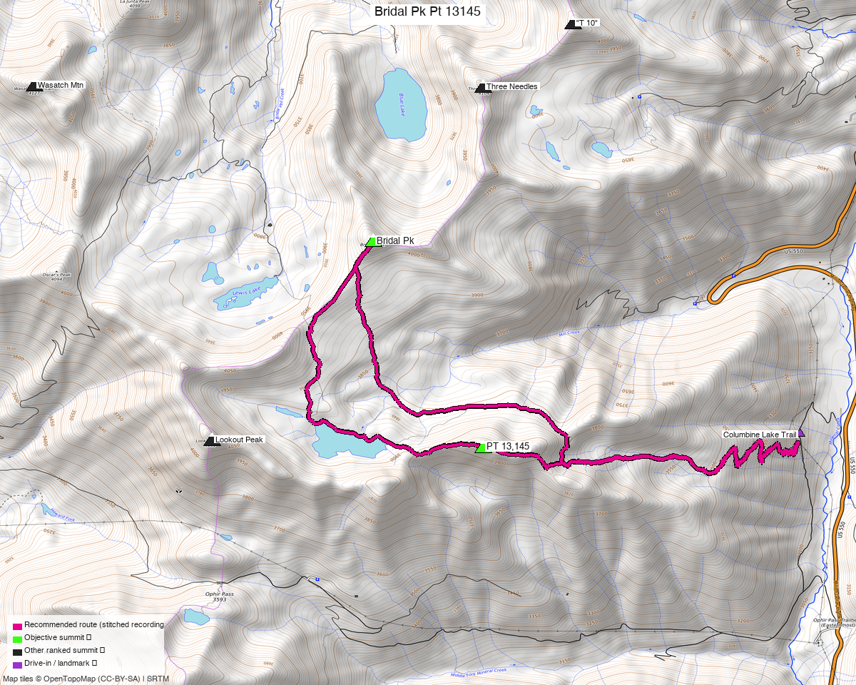
Note: the recommended route was distilled from 12 recorded GPS tracks of real trips (14ers.com · ListsofJohn · peakbagger) — all layered on the interactive CalTopo research map.
Peaks covered
| Peak | Elev | LoJ class | Also known as |
|---|---|---|---|
| Bridal Peak | 13,514' | 2 | peakbagger calls it "T 11" (pid 14671) |
| PT 13,145 | 13,145' | 2+ | older beta calls it "Peak 13159" |
San Miguel / San Juan counties — Uncompahgre National Forest, the ridge above Columbine Lake.
Naming is a mess on these two, which matters when you go looking for beta. Bridal Peak is "T 11" on peakbagger — verified as the same summit, 37.87784/−107.76589 at 13,513.9 ft, matching LoJ to five decimals. PT 13,145 appears as "Peak 13159" in trip reports written before the LiDAR revision.
The recommended route — 8.7 mi / 3,477 ft
A loop from the Columbine Lake trailhead, stitched from three parties' recordings:
| Leg | Distance | Source |
|---|---|---|
| TH → Bridal Peak | 4.06 mi | trk_14ers_5 |
| Bridal → PT 13,145 | 1.28 mi | trk_pb_2 |
| PT 13,145 → TH | 3.34 mi | trk_14ers_4 |
Every recorded party goes via Columbine Lake Trail #509 — about 3.3 mi and 2,300 ft to the lake — then up onto the ridge. This is comfortably the shortest of the two Ophir-area reports and the only one of the pair that is not Class 3.
PT 13,145 is the harder summit, and it is 2+ both ways
Bridal Peak is described as "easy C2". PT 13,145 is the one to plan for: "a fun maze of class 2+ ledges to the summit", and the west-ridge descent is also 2+ — "not as complex but a bit looser than the ascent ledges." Loose San Juan rock on both sides, so there is no easy way off it.
Getting there — Columbine Lake Trail #509
| Drive from Boulder | ~8h 30m via Google Maps |
| Trailhead | Columbine Lake Trail #509, 37.8625, −107.7283, 10,418' — just off CR 820, reached from US 550 near Chattanooga. |
| Road & parking | Rough 2WD. The real constraint is space: "Parking is limited and only about 3 cars can fit where the TH starts, and there aren't too many good places to turn around on this road; weekends are likely a zoo." Start early for the parking as much as for the weather. |
| Land | Uncompahgre NF. The access sweep found the Telluride, Silverton Mountain and Ironton Park ski areas in the wider box; none touch the route. |
Gear & season
- Best window: July through September. One party in late June was routing around lingering snow — "parts of my path were determined by avoiding snow."
- Terrain: Class 2+ ledge navigation on PT 13,145, easy Class 2 on Bridal.
- Helmet: yes for PT 13,145 — the descent ridge is the looser side.
Other considerations
The north group — Trico + "T 10" + Three Needles + Telluride Peak — is the same ridge system: Three Needles sits only ~0.95 mi from Bridal Peak. They are separate reports because the access differs (Black Bear Pass off US 550 vs Columbine Lake off CR 820), but for an 8-hour drive the two together make a natural two-day pairing — this one is the shorter, easier day of the two.
Worth knowing: trk_loj_14571 in the pool is a 14.0 mi day that links Bridal, PT 13,145,
Three Needles and "T 10" in one push. If you would rather do all six peaks in two big days
than four peaks and two, that recording is the proof it goes.
Trip reports & GPX (all three sources)
All three sources swept across both objective peaks and deduped, plus the mapped OSM trail network — all layered on the research map.
- 14ers.com: peaks 10374, 10529 — 6 GPX-library tracks.
- listsofjohn.com: peaks 310, 643 — 3 tracks from 10 trip reports (plus 1 duplicate). LoJ cross-verified the peakbagger ids: 14671 / 92059.
- peakbagger.com: peaks 14671, 92059 — 3 ascent tracks with GPS (plus 4 duplicates).
Sources checked: 14ers.com ✓ · listsofjohn.com ✓ · peakbagger.com ✓