"Baldy Lejos" + PT 13,115 + PT 13,030 — La Garita Wilderness (West Willow / Creede)
At a glance — recommended day
11.8 mi · 3,387 ft gain · Class 2 · 3 peaks · ~5 h drive
✅ Climbed 2026-06-13 — actual: 12.4 mi / 3,558 ft (loop)
Kyle's recorded outing: 12.4 mi · 3,558 ft as a loop from the West Willow upper TH — vs the ~11 mi / ~3,750 ft estimate below. Right trailhead, right loop; ~13% longer. GPS track on file.
NOAA weather link: "Baldy Lejos" + PT 13,115 + PT 13,030 Weather
Drive from Boulder: ~5 h to Creede via Google Maps
CalTopo research map: https://caltopo.com/m/TCFBHE2
Researched: 2026-06-09
Status in Peak Checklist: all three climbed (2026-06-13).
Western part of the seven-peak La Garita narrow-down. The eastern peaks are now two separate reports: the 13,308 + 13,166 bridge pair (same West Willow TH as this trio) and the 13,026 + 13,408 pair (Cochetopa / Eddiesville side).
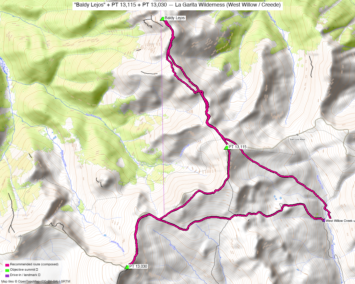
Note: the recommended route was distilled from 9 recorded GPS tracks of real trips (14ers.com · ListsofJohn) — all layered on the interactive CalTopo research map.
Other climbers: Emily Sharpe — not yet · Shawn D Keil — ✓ all
Peaks covered
| "Baldy Lejos" | PT 13,115 | PT 13,030 | |
|---|---|---|---|
| Elevation | 13,118' | 13,115' | 13,030' |
| Lat / Lon | 37.9941, −107.0006 | 37.9694, −106.9872 | 37.9466, −107.0083 |
| Class | 1+ / 2 (tundra) | 2 | 2 |
| CO Rank | 553 | 556 | 619 |
| Also known as | formerly UN 13,100 E | — | formerly UN 13,034 |
| 14ers.com | 10562 | 10554 | 10591 |
| LoJ | 714 | 701 | 788 |
| peakbagger | 84932 | 84934 | 84927 |
| Peak DB id | 714 | 701 | 788 |
All three sit on the divide north of San Luis Pass, within ~3 mi of each other — Baldy Lejos (north) → 13,115 (middle) → 13,030 (south).
Recommended day — West Willow Creek upper TH (San Luis Pass) ⭐
An easy, mostly Class 2 tundra walk — climb13ers calls Baldy Lejos a "Class 1+, mostly tundra hike … may provide opportunity to view a moose."
| Peaks | Baldy Lejos + PT 13,115 + PT 13,030 |
| Recommended loop | the shortest loop through only the three ranked summits (stats in At a glance) |
| Recorded GPX range | 16–20 mi — what parties actually log, because they start low, wander, and bag unranked bumps |
| climb13ers' estimate | ~10.2 mi / ~2,630' — an approximation ("Not intended for use as a GPX track"); both numbers run low vs the measured loop |
| Class | 2 (1+ tundra on Baldy Lejos) |
| Trailhead | West Willow Creek upper TH (~11,500', 4WD — road status not guaranteed; see below) |
Route sequence
The shortest real route is a loop (the 11,500' TH sits between the south and middle peaks, so a loop beats an out-and-back): 1. From the West Willow Creek upper TH, climb NW to "Baldy Lejos" (13,118'), the north summit. 2. Head south down the divide to PT 13,115 — "most will go over 13,115 to reach Baldy Lejos" (climb13ers). 3. Continue south to PT 13,030, then back east/SE to the TH to close the loop.
The recommended route (bold magenta on the map) rides the same ground the recorded tracks (green) walked but trims the sprawl to lower trailheads, the western spur, and the unranked add-on bumps.
The crux is the road, not the difficulty. The upper TH is 4WD-only and climb13ers found the Forest Service had it gated ~1.25 mi below in 2019 for "serious road degradation." Even starting at the 11,500' TH, recorded parties log 16–20 mi because they wander and add unranked peaks — the loop above is the disciplined version.
Drive + approach
| Drive from Boulder | ~5 h to Creede via Google Maps then the rough West Willow Creek 4WD road above town. |
| Access | From Creede (Mineral County Courthouse), go up Willow Creek Rd (FR 503) ~¾ mi to the East Willow / West Willow junction; bear onto West Willow Creek Rd and climb toward San Luis Pass. Last ~1.5 mi is moderate 4WD. |
| Trailhead | West Willow Creek upper TH, ~37.9553, −106.9665, ~11,500' (high-clearance 4WD) — lower parking adds mileage. You do not drive to San Luis Pass (that's a hiking destination north of here); the TH is named for the trail that starts there. 2WD ends at the Equity Mine (~6.7 mi up from Creede); the 4WD continuation to 11,500' has been gated by the FS in recent years — confirm it's open before counting on the high start. |
| Land | La Garita Wilderness (GMUG / Rio Grande NF) — no permits/fees, foot travel only beyond the TH; dispersed camping allowed. |
Pairs with the Phoenix Park group via Creede, not via the mountains. The eastern four use the East Willow → Phoenix Park fork (the roads split ¾ mi above Creede). Base in Creede; the two upper trailheads are ~2–3 h of rough driving apart even though they're close as the crow flies.
Gear & season
- Best window: July through September. High, remote La Garita; the West Willow road and upper basins open late.
- Terrain: benign — rolling alpine tundra, Class 2 with chiprock up high. The challenge is length + altitude + the 4WD approach, not difficulty.
- Storms: wide-open tundra with no fast escape — start early, watch the sky.
- Cell: no 14ers.com reception reports, and it's deep in the La Garita — treat as dead at the TH and on the peaks; carry an InReach / satellite messenger.
Trip reports & GPX (all sources)
Sources confirmed logged in: 14ers.com ("letsgocu"), listsofjohn.com (logged in), peakbagger.com (logged in). 6 GPX tracks swept from the 14ers library — all on the CalTopo map.
14ers.com GPX library (logged in, "letsgocu")
Several recorded outings cover the trio (often with extra unranked bumps); a few showed elevation-sensor noise (one track logged an impossible 37k′ — ignored).
listsofjohn.com (logged in)
Combo TRs confirm the trio is climbed as a set: 17186, 2180 (Baldy Lejos + 13,115 + 13,030 + unranked bumps), and 24545 / 5946 (the trio + the eastern bridge peak 13,308 for a longer day).
peakbagger.com (logged in)
Pages verified for all three; ownership = La Garita Wilderness (GMUG / Rio Grande NF).
climb13ers.com
Baldy Lejos route — "WEST WILLOW CK – SAN LUIS PASS – CREEDE," 10.2 mi / 2,630', recommends combining with 13,115 + 13,030.
Sources checked: 14ers.com ✓ (logged in, "letsgocu") · listsofjohn.com ✓ (logged in) · peakbagger.com ✓ (logged in) · climb13ers.com ✓