Peak C + Peak G — the Ripsaw Ridge pair (Gore, Class 4)
Other climbers: Emily Sharpe — ✓ all · Shawn D Keil — not yet
At a glance — recommended day
15.3 mi · 5,633 ft gain · Class 4 · 2 peaks · ~2.75 h drive
NOAA weather link: Ripsaw Ridge Weather
Drive from Boulder: ~2.5–3h via Google Maps
CalTopo research map: https://caltopo.com/m/F39CE49
Researched: 2026-07-26
Status in Peak Checklist: both unclimbed. The two ranked 13ers anchoring the Ripsaw Ridge — the jagged Gore crest running Peak C → D → E → F → Peak G (D/E/F unranked) above the upper Piney basin, Eagles Nest Wilderness. Both are serious Class 4 Gore scrambles.
Combination Options: - This report IS the combination — 4 of the 6 recorded tracks bag C and G in one 15–17 mi push from Piney Lake, and the recommended loop does the same. - Mount Powell A (13,556) + Eagles Nest A (13,419) share the Piney Lake TH — see the Powell + Eagles Nest report; climb13ers does all four as a 3-day Piney backpack from an ~11,225' basecamp. Worth considering as one trip if you want the whole Piney four. - The full Ripsaw crest traverse (C→G over D/E/F, sustained Class 3–4 with harder steps) is the link-up option for a strong, dry, settled day — see Route.
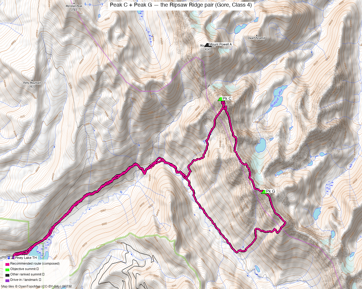
Note: the recommended route was distilled from 9 recorded GPS tracks of real trips (14ers.com · ListsofJohn · peakbagger) — all layered on the interactive CalTopo research map.
Peaks covered
Class 4 — severe exposure, loose Gore rock, hard routefinding
climb13ers calls Peak C "minimum Class 4" with routes "allegedly rated Class 3 to mid-Class 5 — go prepared for a 5th-class climb," exposure "Severe (Not for the Faint-Hearted)", routefinding Difficult. Peak G's SE Ridge is likewise Class 4 with severe exposure. This is committing Gore scrambling on blocky, sometimes-loose rock — helmet mandatory, dry rock only, and turn around if it's wet.
| Peak | Elev | Class (route) | CO rank | peak_db |
|---|---|---|---|---|
| "Pk C" | 13,228' | 4 (West Ridge) | ~#460 | 574 |
| "Pk G" | 13,306' | 4 (SE Ridge) | ~#397 | 533 |
Both sit in the Eagles Nest Wilderness (White River NF) — no permits/fees, wilderness rules. Peak G is a twin summit; the north summit is the true one (13,306' LiDAR) — tag it (the USGS map's contours are wrong here; tagging both settles any doubt).
Getting there — Piney River Ranch (Vail)
Drive from Boulder: ~2.5–3h via Google Maps (origin: 1162 Peakview Circle) — I-70 W to Vail (exit 176), then Red Sandstone Rd → FR 700 ~11 mi of dirt to Piney River Ranch at Piney Lake.
| Trailhead — Piney Lake / Piney River Ranch | ~39.72013,-106.40505, ~9,350' (recorded GPS-track starts). Passenger-car accessible (washboard dirt); busy private ranch at the lake — park in the public TH area. |
| Trail | The Upper Piney River Trail runs the whole approach; the climbing starts where the route leaves it. |
Route — Piney Lake loop over C and G (Class 4)
~15.4 mi · ~5,600 ft round trip — the recommended line is a recorded C+G push followed verbatim (the shortest of the 4 recordings that do both peaks in one day — a real party's actual line, not a composed one, which matters on off-trail Gore terrain):
- Approach: Upper Piney River Trail up the valley ~4 mi toward the head of the basin.
- Peak C via the West Ridge (crux #1, Class 4): leave the trail and climb NE to the Powell–C saddle area, then the West Ridge to C's sharkstooth summit — "minimum Class 4," severe exposure, difficult routefinding; several harder variations exist, so expect to sniff out the easiest line and be comfortable if it briefly feels like low 5th. Ice axe early season.
- C → G link: the recorded parties (and this route) drop off the Ripsaw crest on the Piney side and contour the upper basin south beneath D/E/F, regaining the crest at G — this keeps the link at Class 2–3 instead of the sustained crest scramble.
- Peak G via the SE Ridge (crux #2, Class 4): up the SE ridge to the north (true) summit — Class 4, severe exposure on blocky rock.
- Descent: SW off G into the upper Piney basin and back down the valley to the trail and out — a true loop.
The full Ripsaw crest (C→D→E→F→G) is the aesthetic hard-day alternative — climb13ers: "much of it runs at Class 3 to Class 4" (with harder steps and constant exposure). Only for a settled-weather, dry-rock day with energy to spare; the drop-and-contour line is the standard and the recommendation.
Gear & season
- Best window: mid-July through September — the Gores hold snow late; climb13ers recommends an ice axe for early season on both peaks. Class 4 on wet rock is a no-go — "if the mountain is wet from recent rain or snow, wait for another day."
- Gear: helmet mandatory (loose blocks, parties above); ice axe early season; no rope for the standard lines, but easy to stray into 5th class on C — solid downclimbing confidence required.
- Weather strategy: both cruxes are high and exposed; Gore monsoon builds fast. Early start, C done by mid-morning, off G before the afternoon build-up.
- Cell: dead in the Piney drainage — carry an InReach.
Other considerations
Day trip vs backpack. Strong parties day-trip the pair (~15.4 mi); climb13ers instead backpacks to an ~11,225' camp below C and collects C, Powell, Eagles Nest, and G over 3 days from the same basecamp. If you want all four Piney 13ers (Powell and Eagles Nest are also on your unclimbed list — see the Powell + Eagles Nest report), the basecamp trip is the efficient shape; say the word and that combined trip can be built out.
Rock and exposure are the story here — the mileage is ordinary, but both summits demand sustained attention. This is the Gores: blocky gneiss, "watch for falling mountains" (climb13ers' words), and route-finding that punishes autopilot.
Trip reports & GPX (all three sources)
Sources confirmed logged in: 14ers.com ("Basin"), listsofjohn.com ("letsgocu"), peakbagger.com ("Kyle Knutson"). Both peaks' libraries swept across all three sources and deduped, plus the full OSM trail network — layered on the CalTopo map.
- 14ers.com: peak pages "Peak C" (10226), "Peak G" (10222) — 4 GPX-library tracks (incl. the C+G combo recordings the route is built from).
- listsofjohn.com: "Peak C" (574), "Peak G" (533) — 11 trip reports (text; no downloadable GPX).
- peakbagger.com: Peak C pid 31708, Peak G pid 37294 — 2 ascent GPX pulled.
- climb13ers.com: Peak C West Ridge (Class 4) · Peak G SE Ridge (Class 4) — route + TH beta.
Sources checked: 14ers.com ✓ (logged in, "Basin") · listsofjohn.com ✓ (logged in, "letsgocu") · peakbagger.com ✓ (logged in, "Kyle Knutson")