The Conundrum Creek six — Hunter, Keefe, Hilliard, PT 13,552, PT 13,214, "Triangle" (Class 2+)
Other climbers: Emily Sharpe — not yet · Shawn D Keil — not yet
At a glance — recommended day
24.1 mi · 7,437 ft gain · Class 2+ · 6 peaks · ~5.22 h drive
NOAA weather link: Conundrum Creek Weather
CalTopo research map: https://caltopo.com/m/TJ01U66
Researched: 2026-08-03
Status in Peak Checklist: all six unclimbed.
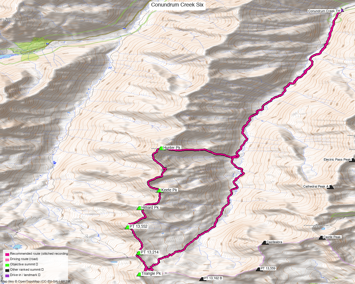
Note: the recommended route was distilled from 15 recorded GPS tracks of real trips (14ers.com · ListsofJohn · peakbagger) — all layered on the interactive CalTopo research map.
Peaks covered
| Peak | Elev | Class | CO rank | Rise |
|---|---|---|---|---|
| PT 13,552 | 13,552' | 2+ | 222 | 777' |
| Keefe Peak | 13,532' | 2+ | 238 | 497' |
| Hunter Peak | 13,506' | 2+ | 253 | 486' |
| Hilliard Peak | 13,422' | 2+ | 306 | 311' |
| "Triangle Peak" | 13,405' | 2 | 319 | 493' |
| PT 13,214 | 13,214' | 2 | 479 | 333' |
Pitkin County, Elk Mountains — a 4.2-mile north–south ridge on the west side of Conundrum Creek, between Castle Peak and the Maroon Bells.
This is one recorded day, not a guess. trk_14ers_3 covers all six summits in a single
26.3-mile round trip from this trailhead, in clean north-to-south order. Two more parties
climbed five of the six in a day — John Kirk in September 2011 and another in July 2024.
The recommended route — 24.1 mi / 7,437 ft
Composed per leg from three recordings, north to south:
TH → Hunter → Keefe → Hilliard → PT 13,552 → PT 13,214 → "Triangle" → TH.
| Leg | Distance | On trail | Source |
|---|---|---|---|
| TH → Hunter Peak | 6.93 mi | 77% | trk_loj_16220 |
| Hunter → Keefe | 1.87 mi | — | trk_loj_16220 |
| Keefe → Hilliard | 0.79 mi | — | trk_loj_16220 |
| Hilliard → PT 13,552 | 0.93 mi | — | trk_14ers_6 |
| PT 13,552 → PT 13,214 | 1.08 mi | — | trk_14ers_6 |
| PT 13,214 → "Triangle Peak" | 0.98 mi | 2% | trk_14ers_6 |
| "Triangle Peak" → TH | 11.48 mi | 90% | trk_14ers_3 |
The long approach up the Conundrum Creek Trail is the price of admission; the six summits themselves occupy about four miles of ridge in the middle of the day, and the exit is 90% on trail.
Composing earns its keep here. The only single recording covering all six is trk_14ers_3 at
26.3 mi; this stitched line does the same six in 24.1 mi, saving 2.2 miles by taking a
better approach and a better exit. (Worth noting the opposite was true of the five-peak version
of this route, where following one track beat the stitch — the right method changed when the
objective set did.)
Twenty-four miles, and the rock is the reason nobody enjoys it
This is a genuinely long day, and the people who have done it are unenthusiastic about the terrain rather than the difficulty. whileyh, who climbed these piecemeal on purpose:
"I want nothing to do with the nasty, rotten connecting ridges of these Conundrum Creek peaks."
and, on the trio he did climb together:
"These sketchy Conundrum Creek peaks seem to only have ONE good route, and even those routes aren't very good."
Nothing in the pool describes a Class 3 move. The grade stays 2+; what you are buying is distance and loose rock, not technical climbing. Helmet and patience.
Getting there — Conundrum Creek
| Drive from Boulder | ~5h 15m via Google Maps — the shortest drive of any report in this Elk cluster, because it comes in from Aspen rather than Crested Butte. Furthermore called it "3½ hours" from Denver. |
| Trailhead | Conundrum Creek TH, 39.11937, −106.85602, 8,779'. OSM maps the lot at capacity 30; Conundrum Creek Road in is unpaved. No 4WD needed. |
| Land | White River NF, Maroon Bells–Snowmass Wilderness. Note the private Highland Ranch parcel 0.86 mi from the lot, on the drive rather than the route. |
Gear & season
- Best window: July through September. The recorded pool runs May to September; the May outing was a snow ascent.
- Terrain: Class 2 to 2+ throughout, on rock that every report describes as rotten. There is no scrambling crux — the difficulty is cumulative.
- Helmet: yes, on the connecting ridges.
- Start early. 24 miles with 7,437 ft is a pre-dawn start even for a fast party; Furthermore was hiking by 4:20 am for a shorter version of this day.
Other considerations
The backpack option is real, and the numbers are striking. Three recorded tracks start not at
the trailhead but at about 10,253', five miles up the Conundrum Creek Trail — a camp. From
there, trk_14ers_6 reaches five of the six in 13.7 miles. Splitting the approach across
two days turns a 24-mile push into a manageable pair of days, and Conundrum Creek is a
well-trodden backpacking corridor.
But check the permit before planning on it. The Conundrum Hot Springs zone is one of the three Maroon Bells–Snowmass Wilderness zones that require a reserved, designated campsite — not dispersed camping — and permits go through Recreation.gov only. Bear canisters are required wilderness-wide. Camping lower in the valley may fall outside the zone; that is worth confirming against the official zone map rather than assumed.
(The 13.7 mi figure is a from-camp day. It is deliberately not the headline number, because quoting it as the route would silently drop the entire approach.)
A Crested Butte approach exists and is worse. Four recorded tracks come at these peaks from the Judd Falls / Copper Creek side — the same trailhead as White Rock + White Benchmark — but they run 21 to 25.6 miles for three peaks or one, against 24.1 for all six from Conundrum. whileyh, who did it that way deliberately, described it as "picking away at these Elk 13ers in the most inefficient way possible from CB" — chosen to avoid the connecting ridges and the drive to Aspen, not because it is shorter.
"Triangle Peak" also belongs to a second group, if you would rather split the day. It sits 0.72 mi south of PT 13,214 at the end of this ridge, and recorded parties reach it two ways: with these peaks from Conundrum Creek (as here), or from Judd Falls — whileyh paired it with PT 13,214 in 2023, and both John Kirk and josephnephi swept it into six- and seven-peak days with Teocalli, White Rock and White Benchmark. If 24 miles is too much for one push, Triangle and PT 13,214 are the natural pair to peel off.
Trip reports & GPX (all three sources)
All three sources swept across all six objective peaks and deduped, plus the mapped OSM trail network — all layered on the research map.
- 14ers.com: peaks 10101, 10100, 10106, 10097, 10122 — 8 GPX-library tracks. None of the six has a formal route description.
- listsofjohn.com: peaks 322, 305, 391, 287, 588 — 3 tracks from 21 trip reports. LoJ cross-verified all six peakbagger ids: 16051 / 5706 / 19398 / 14654 / 19532 / 84915.
- peakbagger.com: those six ids — 1 ascent track with GPS (plus 4 duplicates of another source).
Sources checked: 14ers.com ✓ · listsofjohn.com ✓ · peakbagger.com ✓