La Plata Peak & Ellingwood Ridge
Other climbers: Emily Sharpe — not yet · Shawn D Keil — not yet
At a glance — recommended day
11.1 mi · 4,888 ft gain · Class 3 · 2 peaks · ~3.84 h drive
NOAA weather link: La Plata Peak & Ellingwood Ridge Weather
Drive from Boulder: 3h 55m via Google Maps
CalTopo research map: https://caltopo.com/m/HJ2C6B3
Researched: 2026-08-25
Status in Peak Checklist: unclimbed — La Plata Peak (14,344') is already on the list, so this trip returns to add Ellingwood Ridge, the high point of the eponymous ridge that branches off La Plata's northwest shoulder. The approach shares the same trailhead and the first two-plus miles of the La Plata Trail, making it a natural second visit to a corridor Kyle already knows.
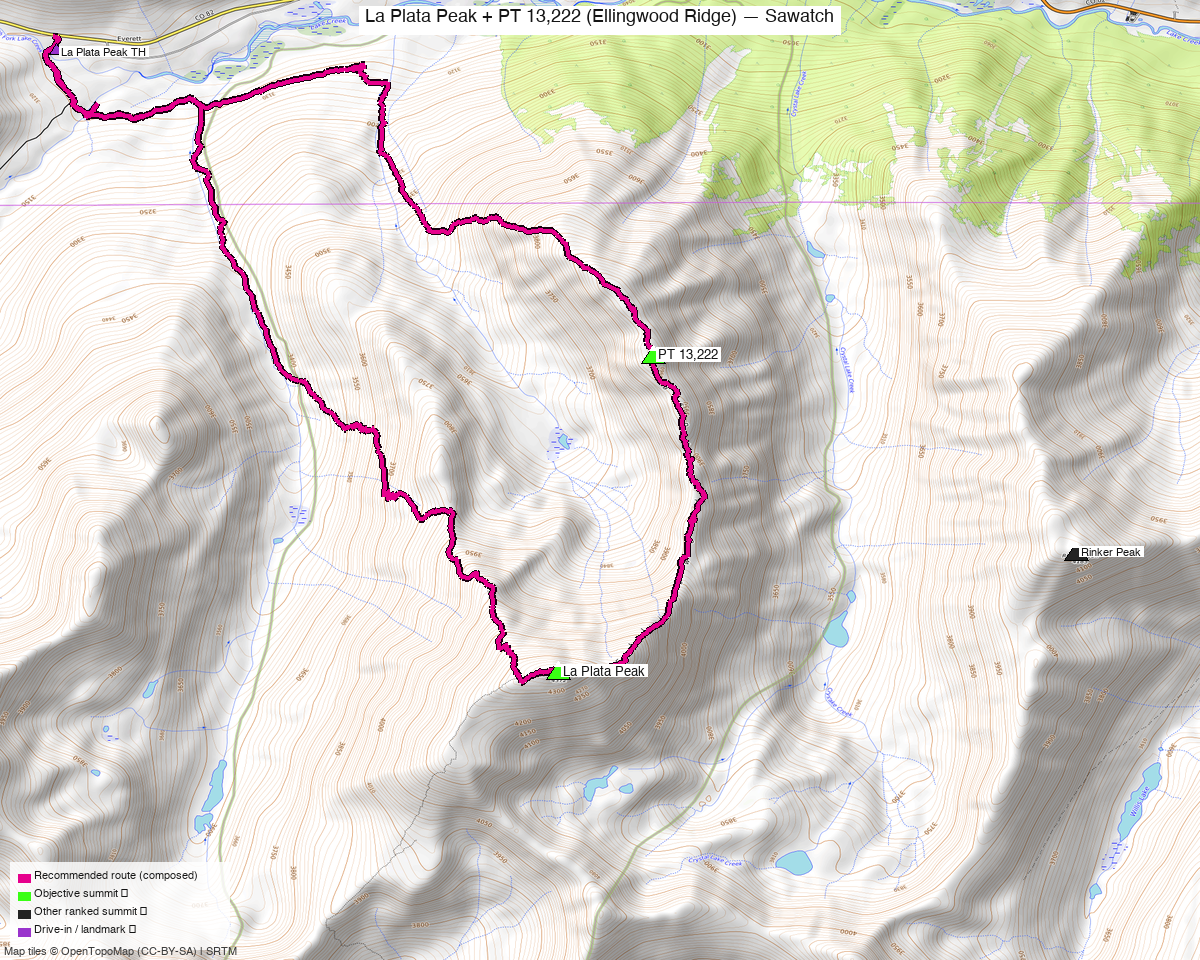
Note: the recommended route was distilled from 45 recorded GPS tracks of real trips (14ers.com · ListsofJohn · peakbagger) — all layered on the interactive CalTopo research map.
Peaks covered
Two peaks on the western Sawatch, in Chaffee County on San Isabel National Forest land, accessed from the paved CO 82 corridor between Aspen and Twin Lakes. La Plata Peak (14,344', CO rank 5) is the anchor — the fifth-highest Colorado 14er, with a hulking northwest ridge above La Plata Gulch. Ellingwood Ridge (13,222', CO rank 468) was only promoted to ranked status after LiDAR pegged it at 13,222' in 2022; it sits at the head of the same gulch on a side arm that branches north off the main La Plata ridge. No permits, no fees; both peaks lie on open National Forest land with no designated wilderness overlay at the TH. Day-use parking fills fast on summer weekends.
| Peak | Elev | Class | CO rank | Status |
|---|---|---|---|---|
| La Plata Peak | 14,344' | 2 | 5 | climbed |
| Ellingwood Ridge | 13,222' | 3 | 468 | unclimbed |
Recommended route — the recommended line ⭐
11.1 mi · ~4,888 ft, Class 3 — a round-trip from the CO 82 paved lot up La Plata Gulch, with an off-trail detour to Ellingwood Ridge first, then back to the trail for La Plata Peak's standard NW Ridge finish. The Ellingwood detour is the crux: a steep, wooded approach to ridge level, a long traverse through open tundra and talus into La Plata Basin, and then a 1,200-foot rock-filled couloir to a saddle — boulder talus, scree, and loose choss the whole way up. 14ers.com rates the combined route Class 3, High exposure, High rockfall potential, High routefinding difficulty. LoJ likewise rates Ellingwood Ridge Class 3. The summit scramble above the saddle adds another short Class 2+ to Class 3 finish to Ellingwood's high point. La Plata Peak itself remains the familiar Class 2 NW Ridge grind — steep, relentless switchbacks but straightforward underfoot. Every recorded summer party (five tracks across 2015–2025) visits Ellingwood Ridge before La Plata Peak, hitting the off-trail branch on the ascent and continuing to La Plata on the way out; that order is pinned here on Class 3 terrain.
Route sequence
- From the La Plata Peak TH (10,148'), walk south on FR391 — cross the North Fork of Lake Creek bridge, ~0.3 mi to the La Plata Trail junction.
- Follow La Plata Trail up La Plata Gulch: cross the South Fork of Lake Creek on a steel bridge, then an unnamed tributary on logs; trail stays east of the creek and climbs steeply through the gulch.
- At roughly 11,025', leave the trail at an open meadow. Climb a steep wooded slope, gaining ~800' to ridge crest at ~11,800'. (The slope is the steepest piece of the off-trail work — sustained but not technical.)
- At the ridge, contour SE through open tundra and talus toward La Plata Basin, losing a little elevation to ~11,700'. Ellingwood Ridge and the couloir come into view from here.
- Cross the willow-choked stream at the basin floor and walk to the foot of the great couloir — a rock glacier tongue with large boulders at its base. About 1,200' of gain to the saddle above.
- Couloir ascent (Class 3): boulder talus, scree, choss. At roughly 1/3 height a large rock outcrop splits the couloir — the left side has less loose scree. Neither side is clean. Take your time; rockfall potential is high.
- At the saddle, turn south for a Class 2+ to Class 3 summit scramble on rock blocks to the Ellingwood Ridge summit (13,222'). One short Class 3 move near the top, minimal exposure. Cairns visible in places.
- Descend the couloir back to the basin, retrace the tundra contour to the La Plata Trail, and turn south-southeast.
- Continue on trail to La Plata Peak (14,344') via the Class 2 NW Ridge — steep, high-friction switchbacks for ~4.5 mi from the TH, but entirely on trail.
- Descend the NW Ridge trail back to the TH.
Getting there — La Plata Peak TH (10,148')
| Drive from Boulder | 3h 55m via Google Maps |
| Trailhead | La Plata Peak TH, 39.06789, -106.50505, 10,148' |
| Road | Paved parking lot directly off CO 82 — no dirt, no clearance needed, passenger car to the TH. 14ers.com confirms the lot "is fully paved and easily accessible to all standard 2WD passenger vehicles." The lot holds 10–15 cars and fills early on summer weekends; 14ers.com recommends arriving before 6 AM or parking legally on the paved CO 82 shoulder (vehicle must be completely clear of the road). No 4WD variant exists — this is the only TH for this route. OSM: Forest Service Road 391 leads south from the lot to the La Plata Trail junction (way 616814966). |
| Land | San Isabel NF, Chaffee County. No permits, no fees. No designated wilderness overlay at the trailhead. |
Gear & season
- Best window: mid-July through September. Five summer round-trip recordings (2015, 2020, 2021, 2024, 2025) cover both objectives; five winter/spring tracks (January–May) were excluded. The couloir holds snow late — an ice axe may be warranted before it clears, typically mid-July or later. climb13ers explicitly notes ice axe recommended for early-season couloir conditions.
- Terrain — Class 3: the Class 3 terrain is concentrated on Ellingwood Ridge: the off-trail couloir (boulder talus, scree, choss, loose) and the brief summit scramble above the saddle. 14ers.com rates the combined route High exposure, High rockfall, High routefinding difficulty. The La Plata NW Ridge itself is Class 2 — steep and sustained, but on trail. No rope, no technical gear required.
- Rockfall: real hazard in the couloir — the left-side line avoids the worst of the small scree but nothing is clean. Helmet strongly recommended for this one. Do not send parties up simultaneously without spacing out.
- ⚠ Water — do NOT filter from La Plata Gulch or South Fork of Lake Creek. 14ers.com FAQ: "The waterways around La Plata Peak… suffer from severe natural and historical mining contamination. They carry high concentrations of toxic heavy metals that standard backcountry backpacking filters and chemical tablets cannot remove." Pack in all water for the day.
- Storms: the Ellingwood detour puts you on exposed tundra and ridgeline from ~11,800' onward — standard Sawatch alpine-start discipline. The couloir and ridge have no shelter.
- Crowds: La Plata Peak is the 5th-highest 14er and popular; the TH lot fills fast on weekends. Expect company on the lower trail. Ellingwood Ridge thins the crowd considerably above the branch point.
- Cell: variable Sawatch coverage — carry an InReach.
Other considerations
Nothing left to combine from this TH. La Plata Peak is already climbed. The only unclimbed peaks reachable from CO 82 in the vicinity use different approach infrastructure: Lake Fork Peak (id 466, 13,333', Class 2) sits ~4.8 mi south off the Sayres Gulch 4WD TH on FR 391/382; Jenkins Mountain (id 370, 13,440', Class 2) is another 5.8 mi out via the same corridor. Neither shares the La Plata Trail approach. Each is its own separate day and report. Drive time (3h 55m) is just under the 4-hour far-from-home threshold, so the corridor pairing isn't flagged as a required mention, but a CO 82 / Twin Lakes camp could batch La Plata + Ellingwood, Lake Fork, and Jenkins into 2–3 days from a single drive.
La Plata solo option. Anyone who has not yet climbed La Plata Peak can tag it alone via the NW Ridge (Class 2, ~9.25 mi / ~4,500 ft per 14ers.com) without the Ellingwood detour — a solid day on its own. Ellingwood is the harder, more committing objective that justifies returning to the corridor.
Route-finding note. The branch-off at ~11,025' for Ellingwood is unmarked. climb13ers describes the slope as visible from the open meadow and provides a GPS waypoint for the intermediate ridge bench (N 39° 03' 04.19" / W 106° 29' 09.63" at ~11,800'). Study the map before leaving the trail — this is the highest-consequence navigation decision of the day.
Trip reports & GPX (all three sources)
Sources confirmed logged in: 14ers.com ("Basin"), listsofjohn.com ("letsgocu"), peakbagger.com ("Kyle Knutson"). All three swept fresh for this build, plus the mapped OSM trails in the bbox — all layered on the research map.
-
14ers.com: 23 track(s) harvested. Peak pages La Plata Peak (10005) and Ellingwood Ridge (10794). The Ellingwood Ridge route on La Plata's page is rated Class 3, High exposure, High rockfall, High routefinding — the definitive combined-route grade used here. The August 2021 round-trip (trk_14ers_15, 11.1 mi / ~4,888 ft) is the recipe track.
-
listsofjohn.com: 5 track(s) harvested. Peak pages La Plata Peak (6) and Ellingwood Ridge (581). LoJ rates Ellingwood Ridge YDS Class 3 — matching the harder estimate adopted here. Five summer and winter tracks total; two winter-season records excluded from recipe consideration.
-
peakbagger.com: 20 track(s) harvested (+21 duplicate(s) of another source). Peak pages La Plata Peak (5744) and Ellingwood Ridge (84738). Of the 20 unique peakbagger tracks, trk_pb_10 (July 2025, 10.1 mi) and trk_pb_14 (July 2020, 11.2 mi) are both clean covering candidates; trk_pb_12 (May 2026) and trk_pb_13 (one-way traverse) were rejected. The 21 duplicates were already held from 14ers.com or LoJ sweeps.
Sources checked: 14ers.com ✓ (logged in, "Basin") · listsofjohn.com ✓ (logged in, "letsgocu") · peakbagger.com ✓ (logged in, "Kyle Knutson")