Trinchera Group — Trinchera + Leaning South + Cuatro + Maxwell (Culebra Range)
At a glance — recommended day
15.6 mi · 6,330 ft gain · Class 2 · 4 peaks · ~4.2 h drive
NOAA weather link: Trinchera Group Weather
Drive from Boulder: 4h 14m via Google Maps
CalTopo research map: https://caltopo.com/m/12TNT68
Researched: 2026-06-09
Status in Peak Checklist: All four 0 ascents (unclimbed). The northern Culebra Range crest, done as one N→S ridge traverse.
Access — public east side, NOT the Cielo Vista Ranch fee: these summits sit on the Culebra crest, the east edge of Cielo Vista Ranch. The standard way to climb all four is from the public Blue Lakes Trailhead (Cuchara / east side, San Isabel NF) — NE slopes up Trinchera, then the ridge south. No ranch reservation/fee is needed for this east-side traverse (the ranch is west of the crest). (whileyh 2019; stavislost route writeup.)
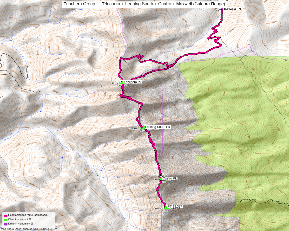
Note: the recommended route was distilled from 10 recorded GPS tracks of real trips (14ers.com · ListsofJohn · peakbagger) — all layered on the interactive CalTopo research map.
Other climbers: Emily Sharpe — not yet · Shawn D Keil — ✓ all
Peaks covered
| Trinchera Pk | "Leaning South Pk" | Cuatro Pk | Mt Maxwell | |
|---|---|---|---|---|
| Elevation | 13,522' | 13,218' | 13,492' | 13,337' |
| Lat / Lon | 37.28911, −105.16478 | 37.27470, −105.15982 | 37.25837, −105.15456 | 37.24923, −105.15352 |
| Class | 2 | 2 | 2 | 2 |
| CO Rank | 243 | 472 | 266 | 365 |
| Prominence | 957' | 317' | 708' | 305' |
| 14ers.com | 10639 | 10671 | 10646 | 10661 |
| LoJ | 302 | 610 | 329 | 454 |
| peakbagger | 5923 | 96812 | 15162 | 15529 |
| Peak DB id | 302 | 610 | 329 | 454 |
The four form a N→S crest chain over ~2.8 mi: Trinchera → Leaning South (1.0 mi) → Cuatro (1.2 mi) → Maxwell (0.6 mi). All Class 2.
A standard Culebra crest traverse — done as one outing in the trip reports (whileyh 2019 linked all four + Leaning North + English Saddle in a single day from Blue Lakes). The connecting ridge is Class 2 throughout, so once you're on the crest it's a walk from summit to summit.
Combos (ranked rule): all four are ranked 13ers — a true 4-ranked-peak day. Bonus on the same ridge: "Leaning North Peak" (13,112', ranked) sits between Leaning South and Trinchera and is trivially added; the Mariquita/De Anza peaks to the south are already done.
Recommended plan — Blue Lakes → Trinchera NE slopes → crest traverse S ⭐
The standard line (whileyh 2019 / stavislost).
Combo stats:
| Source | Peaks | Distance | Gain |
|---|---|---|---|
| whileyh 2019 (LoJ 7823) | all 4 + Leaning North + English Saddle | 18.4 mi | ~7,116' |
| John Kirk 2014 (LoJ 957) | Cuatro + Leaning S + Leaning N (partial) | 14.2 mi | ~4,912' |
Expect roughly ~14–18 mi and ~4,900–7,100 ft for the four-peak day — a big Class 2 traverse (gain/length depend on how high the Blue Lakes road is driven and whether you out-and-back vs. loop). Plan a full alpine day with an early start.
Route sequence
- From Blue Lakes TH (~10,500'), climb the NE slopes of Trinchera Peak (13,522') — Class 2.
- Traverse the crest south: Trinchera → Leaning South Pk (13,218') (grab Leaning North 13,112' en route if wanted) → Cuatro Pk (13,492') → Mt Maxwell (13,337') — Class 2 ridge throughout.
- Descend east off the crest back toward Blue Lakes (or reverse the ridge). The east-side descent lines avoid ranch land.
Per-peak route notes
- Trinchera Peak — the high point (13,522', 957' prom); standard Class 2 NE slopes from Blue Lakes, the traverse's anchor.
- "Leaning South Peak" — Class 2 ridge bump between Trinchera and Cuatro.
- Cuatro Peak — 13,492' (708' prom); Class 2, the second-highest of the four.
- Mt Maxwell (PT 13,337) — Class 2, the south end of the chain, 0.6 mi from Cuatro.
Getting there — Blue Lakes TH
| Drive from Boulder | 4h 14m via Google Maps (~232 mi, origin: 1162 Peakview Circle; via I-25 S + CO-12 E through La Veta / Cuchara) |
| Trailhead | Blue Lakes TH, ~37.31247, −105.13871, ~10,500' (Blue Lakes Campground, off CO-12 / Cuchara Pass — Blue Lakes Rd / FR 422). Public, San Isabel NF. |
| Access note | No Cielo Vista Ranch fee for this east-side approach — the ranch is west of the crest. Stay east of the ridgeline; the summits are on the boundary. |
Permits / access:
- San Isabel National Forest (Blue Lakes / Cuchara, east side) — no permits, no fee.
- Cielo Vista Ranch is private and west of the crest; the east-side traverse does not require its paid-access program. Keep descents east of the ridgeline to stay on public land.
Gear & season
- Best window: July through September. High Sangre crest; the Blue Lakes road and upper basin open late.
- Storms: a long, fully-exposed crest traverse — afternoon monsoon storms are the main hazard. Start very early; you're on the ridge for hours.
- Terrain: Class 2 tundra/talus throughout — no technical sections, but it's a long day at altitude.
Cell coverage:
- 14ers.com community DB: no submitted reception reports for these summits.
- Geographic reasoning: the Blue Lakes approach and basins are likely dead — deep in the Sangre. Summits may catch some signal east toward the Cuchara/Walsenburg side but treat it as unreliable.
- Standard recommendation: carry an InReach / satellite messenger — long, committing traverse.
Trip reports & GPX (all three sources)
Sources confirmed logged in: 14ers.com ("Basin"), listsofjohn.com ("letsgocu"), peakbagger.com ("Kyle Knutson"). 7 GPX tracks swept (LoJ traverse + peakbagger ascents) — all layered on the CalTopo map, colored by source.
listsofjohn.com
| GPX | Peaks |
|---|---|
| 7823 | all 4 + Leaning North + English Saddle (whileyh, the full traverse) ⭐ |
| 957 | Cuatro + Leaning South + Leaning North (John Kirk) |
| 4060 | Maxwell + Mariquita area |
14ers.com (logged in, "Basin")
Peak pages exist for all four; no formal route descriptions — route beta is TR-only (+ the stavislost traverse writeup).
peakbagger.com (logged in, "Kyle Knutson")
Ascent GPX pulled for all four — Trinchera (5923), Leaning South (96812), Cuatro (15162), Maxwell (15529) — layered on the CalTopo map.
Sources checked: 14ers.com ✓ (logged in, "Basin") · listsofjohn.com ✓ (logged in, "letsgocu") · peakbagger.com ✓ (logged in, "Kyle Knutson")