Wayah Group — 6 unclimbed ranked 13ers (Sawatch ridge loop)
At a glance — recommended day
16.5 mi · 7,036 ft gain · Class 3–4 · 6 peaks · ~3.5 h drive
NOAA weather link: Wayah Group Weather
Drive from Boulder: ~3h 30m via Google Maps
CalTopo research map: https://caltopo.com/m/PFSV1BL
Researched: 2026-06-16
Status in Peak Checklist: all six unclimbed. These are Kyle's share of the 8-peak "Wayah Group" — the long ridge NW of Mount Massive / Mount Oklahoma (both already done), between the Hunter-Fryingpan Wilderness and Hwy 82 (Independence Pass).
Six ranked 13ers strung along one long, committing ridge. Do them all in one ~16.4 mi loop from the end of Wildcat Road — or break them into 3 clean ~8–11 mi day-loops off three different trailheads.
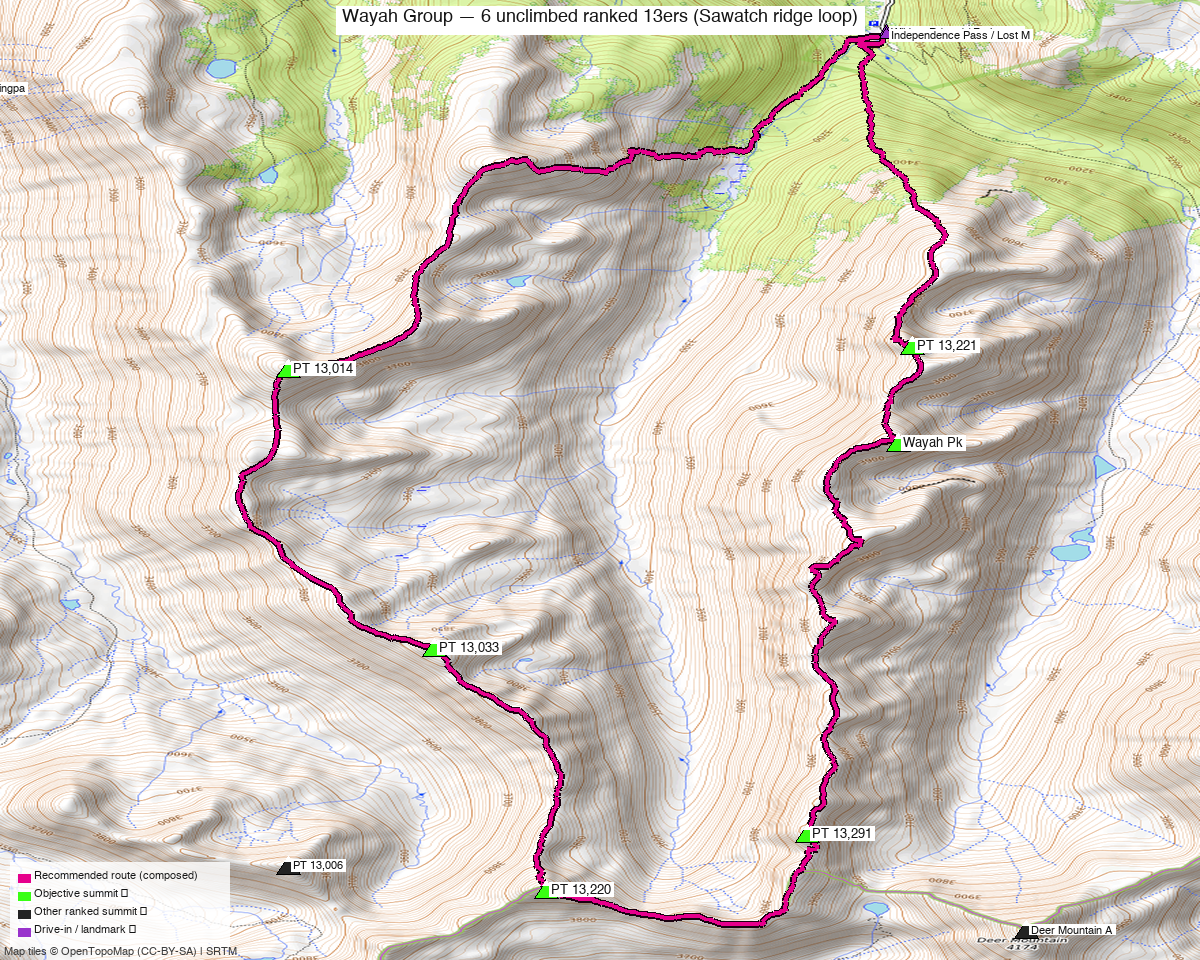
Note: the recommended route was distilled from 12 recorded GPS tracks of real trips (14ers.com · ListsofJohn) — all layered on the interactive CalTopo research map.
Other climbers: Emily Sharpe — 2 of 6 (PT 13,291, PT 13,220) · Shawn D Keil — not yet
Class — this is a Class 3–4 ridge, not a walk-up
- Summits: Class 2 except PT 13,291 (Class 3) and PT 13,220 (Class 2 via a game trail, 5th-class if taken direct).
- Linking the peaks along the crest is Class 3–4 scrambling with real exposure on loose rock; Class 5 towers on the unranked points must be bypassed (per Chipmunk's "A Tale of Two Ridges" TR).
- Helmet; a rope is reasonable for the harder bits.
Peaks covered
| PT 13,220 | PT 13,291 | PT 13,033 | PT 13,014 | Wayah Pk | PT 13,221 | |
|---|---|---|---|---|---|---|
| Elevation | 13,220' | 13,291' | 13,033' | 13,014' | 13,277' | 13,221' |
| Lat / Lon | 39.1615, −106.5516 | 39.1669, −106.5350 | 39.1851, −106.5585 | 39.2124, −106.5677 | 39.2053, −106.5292 | 39.2148, −106.5281 |
| Class (summit) | 2 (5th direct) | 3 | 2 | 2 | 2 | 2 |
| Ridge position | far S | S | mid | NW | N | far N |
| CO Rank | 471 | 407 | 617 | 628 | 418 | 469 |
| 14ers.com | 10801 | 10769 | 10833 | 10835 | 10775 | 10797 |
| LoJ | 611 | 491 | 792 | 814 | 511 | 595 |
| peakbagger | 84737 | 84749 | 84725 | 84724 | 84746 | 84747 |
All six are ranked Sawatch 13ers in the Hunter-Fryingpan Wilderness. The full "Wayah Group" is 8 ranked 13ers (+ a couple of 12ers); the other two are already done. ("Wa'ya" = wolf in Cherokee.)
Option A — all six in one loop ⭐ big day
A loop over all six from the end of Wildcat Road (the north Fryingpan-Lakes-area trailhead, ~11,400') — no car shuttle needed. Up onto the ridge, around the horseshoe over all six, and back down to the same TH.
- Loop order: PT 13,014 → PT 13,033 → PT 13,220 → PT 13,291 → Wayah Pk → PT 13,221 → back (reverse works too).
- Difficulty: stay on the crest for Class 3–4 scrambling; the few Class 5 towers (on the unranked bumps) get bypassed west or east. Loose rock and exposure — helmet, and a rope is reasonable.
- The day is the scrambling + the gain at 13k', not the mileage — you're on an exposed crest for hours, so a stable-weather window is essential. Recorded parties do the full 8-peak group as a longer outing; Kyle's six is the loop above.
Getting there
| Drive from Boulder | ~3h 30m via Google Maps — to the end of Wildcat Road (the north Fryingpan-Lakes-area TH, ~11,400') for the full loop. The split-loop trailheads are off Hwy 82 (Independence Pass) and the Fryingpan / South Fork Pass side. (Confirm the Wildcat Rd surface/closure before you go.) |
| Trailheads | Wildcat Rd / Fryingpan Lakes TH (~39.245, −106.530, ~11,400') — the loop start · North Fork Lake Creek TH (~39.115, −106.539, Hwy 82) — south pair · South Fork Pass / Fryingpan (~39.240, −106.593) — middle pair. |
| Land | Hunter-Fryingpan Wilderness (White River NF) — no permits/fees, foot travel only; PT 13,220 also borders the Mount Massive Wilderness. |
Gear & season
- Best window: July–September. High, remote Sawatch ridge; the traverse needs dry rock and a stable-weather day (long, exposed, committing).
- Terrain: Class 2 tundra/talus to the summits; Class 3–4 scrambling on loose rock to link them, with bypasses around the Class 5 towers. Willows and a faint approach on the North Fork Lake Creek side.
- Storms: you're on an exposed crest for hours on the traverse — very early start, or split it into the short loops.
- Cell: dead — carry an InReach.
Other considerations
Option B — split into 3 short day-loops (real recorded routes). Each pair sits above its own trailhead, so the relaxed way is three ~8–11 mi loops (combine any two for a 2-day weekend):
| Loop | Peaks | Trailhead | Stats |
|---|---|---|---|
| South pair | PT 13,291 (Cl 3) + PT 13,220 | North Fork Lake Creek TH (Hwy 82) | ~10.5 mi / ~3,580′ |
| North pair | Wayah Pk + PT 13,221 | Independence Pass / Lost Man (Hwy 82) | ~7.9 mi |
| Middle pair | PT 13,033 + PT 13,014 | South Fork Pass / Fryingpan (Frying Pan Rd) | ~10.8 mi |
- The south pair is the cleanest single day and gets you the Class 3 peak (PT 13,291) — a good first bite.
- The north and middle pairs are best off the Fryingpan / upper-Hwy-82 side; combine them if camping near South Fork Pass.
Trip reports & GPX (all sources)
Sources confirmed logged in: 14ers.com ("Basin"), listsofjohn.com, peakbagger.com (Kyle Knutson). Tracks layered: the full-group traverse + the south-pair and north-pair loops.
- 14ers.com: key beta — Chipmunk, "A Tale of Two Ridges: the Wayah Group" (9/2024): full route + the Class 3–4 / 5.bypass difficulty detail; also geojed's 11-peak "Cheaper by the Eleven" (2012). GPX library has the south-pair "13220 & 13291 from North Fork Lake Creek" track.
- listsofjohn.com: per-peak pages — all six ranked Sawatch 13ers (611 · 491 · 792 · 814 · 511 · 595).
- peakbagger.com: pages verified for all six; ownership = Hunter-Fryingpan Wilderness (White River NF).
- climb13ers.com: consulted (these obscure ridge points have minimal dedicated route pages; class corroborated by the 14ers TR).
Sources checked: 14ers.com ✓ (logged in, "Basin") · listsofjohn.com ✓ · peakbagger.com ✓ (logged in, "Kyle Knutson") · climb13ers.com ✓