Sunshine Mountain & PT 13,094
Other climbers: Emily Sharpe — not yet · Shawn D Keil — ✓ all
At a glance — recommended day
6.8 mi · 3,316 ft gain · Class 2 · 2 peaks · ~9.42 h drive
NOAA weather link: Sunshine Mountain & PT 13,094 Weather
Drive from Boulder: 9h 30m via Google Maps
CalTopo research map: https://caltopo.com/m/K05K1RT
Researched: 2026-09-01
Status in Peak Checklist: unclimbed. Two easy Class 2 summits on the Alpine Loop accessible from a single roadside pullout on the descent from Engineer Pass — a compact, efficient day in the upper Henson Creek basin. At 9h 30m it's a committed drive, making trip-pairing with nearby unclimbed Engineer Pass area peaks worth planning up front.
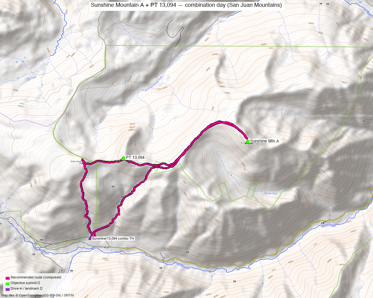
Note: the recommended route was distilled from 7 recorded GPS tracks of real trips (14ers.com · ListsofJohn · peakbagger) — all layered on the interactive CalTopo research map.
Peaks covered
Sunshine Mountain A (13,329', CO rank #371) and PT 13,094 (13,094', CO rank #571) occupy the upper Henson Creek basin in the San Juan Range, Gunnison National Forest, Hinsdale County. The area carries no wilderness designation: no permits, no entry fees, and no formalities for day use. The surrounding Henson Creek / Engineer Pass corridor is part of the Alpine Loop, a well-known 4WD scenic byway open to the public. Primitive camping is available at-large along CR20 (the Henson Creek road); there are no developed campgrounds in this stretch of the drainage, though a vault toilet sits ~1.7 mi east of the TH near Rose Cabin.
| Peak | Elev | Class | CO rank | Status |
|---|---|---|---|---|
| Sunshine Mountain A | 13,329' | 2 | 371 | unclimbed |
| PT 13,094 | 13,094' | 2 | 571 | unclimbed |
Recommended route — the recommended line ⭐
6.8 mi · ~3,316 ft, Class 2 — an honest out-and-back from the south-side Engineer Pass TH, confirmed by two independent SUMMER 2020 recordings that both measure 6.8 mi RT and agree on visit order: PT 13,094 first, Sunshine Mountain A second. Terrain is predominantly tundra throughout; the climb to PT 13,094 involves rubble and talus in the upper 400–500 ft above the approach saddle, while the ~2-mile traverse east to Sunshine tracks mostly grassy slopes with scattered rocky outcrops. The ridge narrows and becomes rockier in the final approach to Sunshine's summit but there is no exposure and routefinding is easy the whole way. climb13ers rates the combined day "Medium Day // Take a Lunch." The 6.8 mi is the composed-line floor; plan on covering somewhat more on the ground.
Route sequence
- Engineer Pass TH (11,007') — depart north off the road pullout; the upper Henson Creek basin opens above you quickly as the valley falls away south.
- PT 13,094 (13,094', ~2,100 ft gain) — ascend tundra slopes heading north; the upper 400–500 ft above the approach saddle is rubble and talus before the summit plateau. Views from the top include Uncompahgre Peak towering behind Sunshine Mountain to the east.
- Traverse east to Sunshine Mountain A (~2 mi) — drop from PT 13,094 east to the connecting saddle on talus, cross a tundra bench, then continue east-then-southeast on mostly grassy ground. As you near the summit (13,329') the ridge narrows and becomes rockier, but the climbing stays easy and the gain from the saddle is modest.
- Return (13,329' → 11,007') — retrace the same ridge and south slopes; both recorded parties returned via the same line.
Getting there — Engineer Pass TH (11,007')
| Drive from Boulder | 9h 30m via Google Maps |
| Trailhead | Engineer Pass TH, 37.97798, -107.54078, 11,007' |
| Road | Engineer Pass Road (Alpine Loop, OSM grade3, surface=ground, smoothness=very_bad). From Silverton: CR2 east through Howardsville and up the Animas canyon, then follow signs for Engineer Pass — 4WD with good clearance required; the road narrows and steepens over the pass before descending into upper Henson Creek. From Lake City: CR20 west along Henson Creek 9.1 miles to Capitol City, then the Alpine Loop road (BLM3303) west-and-up — high-clearance recommended, passable to capable high-clearance 2WD in dry conditions per climb13ers. The TH is a cluster of pullouts on the north side of the road; no developed parking or trailhead signage. |
| Land | Gunnison National Forest. No wilderness designation. No permits or day-use fees. Primitive camping at-large along CR20 (mind private property and historic claims in the valley); vault toilet ~1.7 mi east near Rose Cabin. |
Gear & season
- Best window: July–August. Both SUMMER recordings are from July 2020; a peakbagger ascent from August 2021 (stavislost.com TR) corroborates the window. No reliable summer data exists from before July; snow lingers on north-facing talus into early summer.
- Footwear: trail runners or sturdy approach shoes are sufficient — Class 2 throughout; the rubble/talus section on PT 13,094 is the technical crux and it is not steep enough to require anything beyond sure footing.
- No technical gear required. Zero exposure on the entire recommended line per climb13ers; routefinding is listed as easy.
- Storms: the upper basin is fully exposed tundra ridge above 12,000' with no quick shelter — standard San Juan monsoon discipline, summit PT 13,094 by late morning.
- Cell: assume no coverage in the upper Henson Creek corridor; both Lake City and Silverton are the last reliable signal before the drive in.
Other considerations
-
Trip-pair this drive. At 9h 30m from Boulder, a round trip for just these two peaks is a hard sell on its own. The same Engineer Pass / Hinsdale County area has a cluster of unclimbed 13ers on separate trailheads — PT 13,382 (id=421), PT 13,215 (id=602), PT 13,155 (id=645), and PT 13,180 A (id=625, which already has a published report at Alpine Gulch TH, 7h 05m drive) — and Campbell Creek Peak (id=357, Grizzly Gulch, ~7h drive) is a further pairing option in the same broad Hinsdale County corner. A dedicated multi-day trip into the area could clear several unclimbed summits in one drive. Note that Heisshorn (id=388, ~5.7 mi away) is Class 5.3 — a technical objective, different trip entirely.
-
Shorter line than the historical beta. The climb13ers documented a western approach via Dolly Varden Mountain from Henson Creek West TH (11,410', 0.82 mi farther west on CR20) yielding 8.5 mi / 2,880 ft RT — 1.7 miles longer and involving an extra high-12er traverse. Our cluster-1 south approach avoids Dolly Varden entirely and is the more efficient line; it is also the line that two independent parties independently chose in July 2020.
-
One-way descent option (optional variation). climb13ers noted a descent from the saddle east of PT 13,094 via an old mining road dropping south to CR20 near Rose Cabin — avoiding a re-climb over PT 13,094 on return. The mining road is intermittent and adds a ~¾-mile road walk back to the TH. It's noted as an option, not a recommendation; the out-and-back on the same ridge is the simpler and well-evidenced shape.
Trip reports & GPX (all three sources)
Sources confirmed logged in: 14ers.com ("Basin"), listsofjohn.com ("letsgocu"), peakbagger.com ("Kyle Knutson"). All three swept fresh for this build, plus the mapped OSM trails in the bbox — all layered on the research map.
-
14ers.com: 2 track(s) harvested from peak pages 10446 (Sunshine Mountain A) and 10566 (PT 13,094). Track availability is consistent with the modest ascent history of these peaks on that site.
-
listsofjohn.com: 3 track(s) harvested from peak/468 (Sunshine A) and peak/725 (PT 13,094), +3 duplicates of peakbagger tracks. The July 2020 LoJ recording (loj_tr16634_gpx8394) became one of the two primary inputs for the recommended route, measuring 6.8 mi RT with visit order PT 13,094 → Sunshine A — confirmed independently by the matching peakbagger track from the same day.
-
peakbagger.com: 2 track(s) harvested from pid=15112 (Sunshine A) and pid=19480 (PT 13,094), +4 duplicates across sources. Peakbagger shows 18 total logged ascents of Sunshine Mountain; the July 2020 track (pb_aid1418526) independently corroborates the LoJ route at 6.8 mi RT with the same visit order — strong two-source confirmation of the recommended line and direction.
Sources checked: 14ers.com ✓ (logged in, "Basin") · listsofjohn.com ✓ (logged in, "letsgocu") · peakbagger.com ✓ (logged in, "Kyle Knutson")