Star Peak Group — Star + Taylor day trip (Elk Mountains)
At a glance — 1-day trip
2 peaks · ~3.7 h drive
- Day 1 (Star + Taylor): 9.45 mi · 4,979 ft gain · Class 2 · 2 peaks
NOAA weather link: Star Peak Group Weather
Drive from Boulder: 3h 40m via Google Maps
CalTopo research map: https://caltopo.com/m/FK5NN3V
Researched: 2026-06-07
Status in Peak Checklist: Both unclimbed. Star + Taylor are a natural Class 2 pair above the Mt Tilton Trail on the east Taylor Park side of the Elk crest — done together in every trip report that hits either. Italian Mountain was originally bundled with this trip; it's actually climbed from a different trailhead system (Cement Creek off CR 740, in Gunnison) and gets its own report (forthcoming).
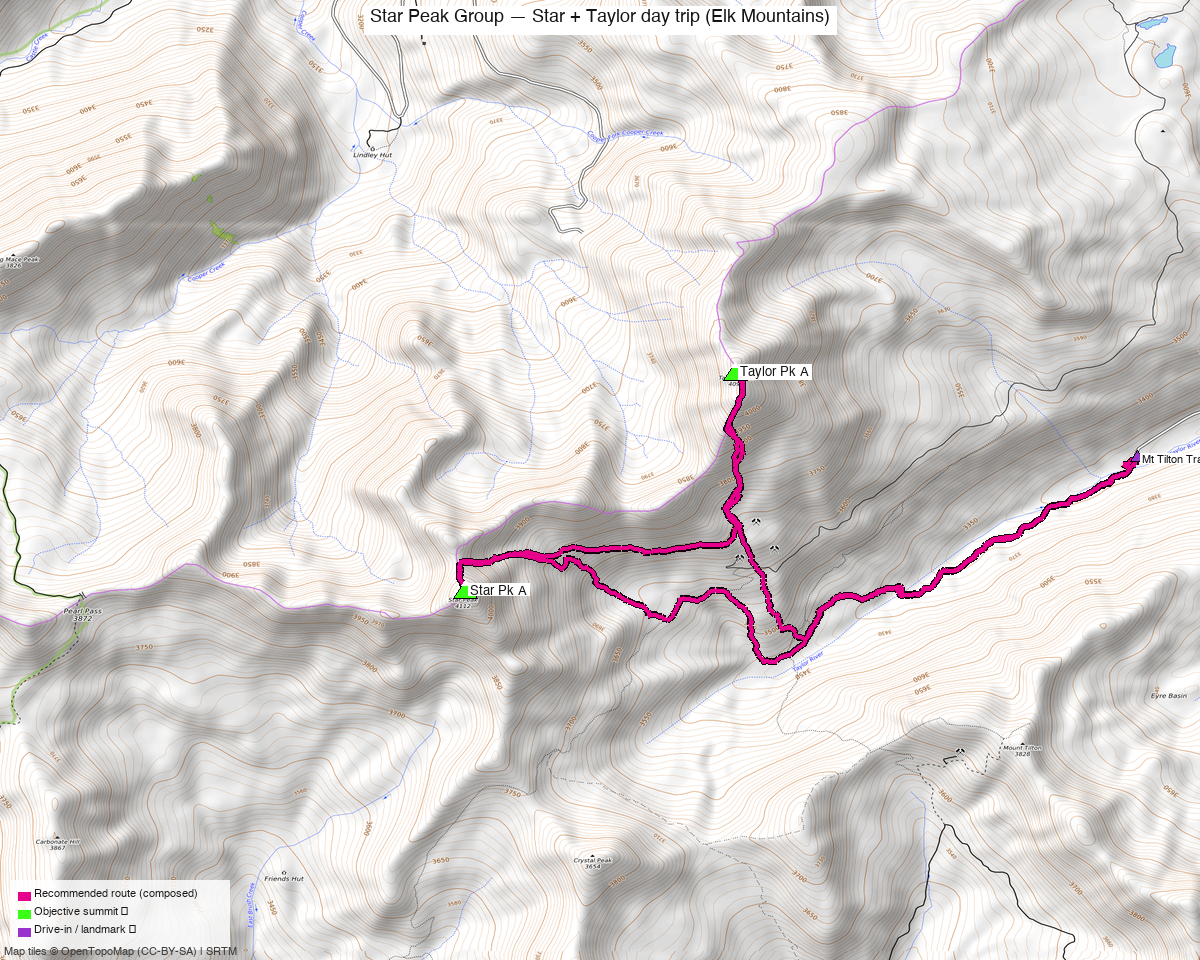
Note: the recommended route was distilled from 7 recorded GPS tracks of real trips (14ers.com · ListsofJohn · peakbagger) — all layered on the interactive CalTopo research map.
Other climbers: Emily Sharpe — not yet · Shawn D Keil — ✓ all
Peaks covered
A Class 2 day trip on the Mt Tilton Trail out of the east Taylor Park side of the Elk crest — Star and Taylor sit 1.25 mi apart on a connecting Class 2 ridge, done together in every recorded trip report of either.
| Star Peak A | Taylor Pk A | |
|---|---|---|
| Elevation (LiDAR) | 13,527' | 13,438' |
| Lat / Lon | 38.97963, −106.79967 | 38.99204, −106.78261 |
| Class (standard) | 2 | 2 |
| CO Rank | #241 | #299 |
| Prominence | — | 817' |
| Range | Elk Mtns (Taylor Park) | Elk Mtns (Taylor Park) |
| County | Gunnison/Pitkin | Gunnison |
| 14ers.com | 10099 | 10104 |
| LoJ | 301 | 365 |
| peakbagger | pid 14666 | pid 15740 |
Neither summit carries a wilderness designation. Italian Mtn (13,385'), originally bundled with this pair, is climbed from the Cement Creek TH off CR 740 in Gunnison County — a different road system and separate report (see Other considerations).
Itinerary
Single Class 2 day — 9.45 mi / ~4,979 ft from the Mt Tilton Trail TH, composed from josephnephi's 2024 recording and now reproducible from a recorded recipe rather than recomposed from scratch on every build.
The line takes Star first, then traverses the ridge NE to Taylor and returns — the order that recording walks. Recorded days for the pair run 8.6–10.7 mi depending on how much of the ridge each party included:
| Source track | Peaks | Distance | Gain |
|---|---|---|---|
| whileyh 2020 (LoJ 17731) | Star + Taylor | 8.6 mi | ~4,311' |
| John Kirk 2016 (LoJ 7235) | Star + Taylor (+Crystal) | 10.7 mi | ~5,883' |
| peakbagger Star aid1533069 | Star + Taylor | 8.6 mi | — |
Getting there — Taylor Park
| Drive from Boulder | 3h 40m via Google Maps (origin: 1162 Peakview Circle) |
| Trailhead | Mt Tilton Trail, end of CO 742 (~38.987, −106.757, ~10,750') — east of Taylor Park Reservoir, reached via Cottonwood Pass from Buena Vista |
| Seasonal access | Cottonwood Pass / CO 742 is seasonally closed — typically late May to late October. Verify CDOT before driving. |
Route — Star + Taylor (Class 2)
- From the end of CO 742 / Mt Tilton Trail TH, hike the Mt Tilton Trail ~1.5 mi (trail runs on the north side of the stream, contrary to the topo).
- Leave the trail and climb toward Star Peak A (13,527', Class 2), the higher and further of the pair — taken first, which is the order the recorded line walks.
- Follow the connecting ridge NE ~1.25 mi (Class 2) to Taylor Peak (13,438').
- Descend Taylor's west ridge past the old mine workings to the Taylor Pass junction and out via the same trail.
Neither peak carries a formal 14ers.com route description ("no route descriptions… try the Trip Reports") — the standard line is this Taylor→Star ridge from the Mt Tilton Trail, Class 2 throughout.
Camps & water
- Dispersed camping plentiful near the end of CO 742 (fills on summer weekends) — car camp near the TH if driving in the night before.
- No wilderness permits — the summits are on Gunnison NF land outside designated wilderness. No fees.
Gear & season
- Best window: late June through early October. Snow lingers in the basins into early summer.
- Access window: Cottonwood Pass / CO 742 seasonal closure (≈ late May–late October) gates the whole trip — verify CDOT first.
- Terrain: Class 2 tundra, grass, and talus; no technical difficulty on the standard lines. Old mining roads/workings aid the lower Taylor approach.
- Storms: long exposed ridges and tundra — early start, off the high ground by early afternoon (especially for the big one-day link).
- Cell coverage: no submitted reception reports in the 14ers.com community DB for these summits/TH (typical for the East Taylor Park backcountry). Geographic reasoning: the Mt Tilton TH and lower basins are likely dead — deep in East Taylor Park, shadowed from towers; summits may catch intermittent signal with line-of-sight east, but don't count on it. Carry an InReach / satellite messenger, especially for the big one-day link.
Other considerations
Italian Mountain (originally bundled here) is climbed from a different trailhead. The initial draft of this report grouped Star + Taylor + Italian assuming a shared Taylor Park approach, but Italian's standard route is off Cement Creek Rd (CR 740) in Gunnison County — a separate road system ~5 mi SE of the Mt Tilton TH. climb13ers describes it as "an easy Class 2 hike that can be completed in a morning" from the Cement Creek — Italian Mtn TH (4WD). Italian is worth building as its own report (pending); trying to shoehorn it in with Star + Taylor produced a 26+ mi routed day that went through Star Peak's basin to reach it.
Trip reports & GPX (all three sources)
listsofjohn.com
| Date | Author | Peaks | GPX |
|---|---|---|---|
| 2024-06-28 | josephnephi | Star + Taylor + Italian + Lambertson + 5 sub-peaks | 16120 ⭐⭐ all three |
| 2020-11-06 | whileyh | Taylor + Star | GPX in repo — clean pair baseline |
| 2016-09-05 | John Kirk | Star + Taylor + Crystal | TR 7235 |
| 2012-09-15 | Furthermore | Star + Taylor + Crystal | TR 1689 — confirms "TH: end of CO 742, Mt Tilton Trail" |
| 2021-06-13 | whileyh | Italian + Lambertson + American Flag | TR 19478 — Italian via CR 742→748→744 |
| 2012-09-14 | Furthermore | Italian + Lambertson + American Flag | TR 1688 — Italian via Star Mine / CO 759 / Cement Creek |
14ers.com (logged in, "Basin")
Peak pages exist for all three but carry no formal route descriptions — route beta comes from the trip reports. 14ers GPX-library track layered on the research map.
peakbagger.com (logged in, "Kyle Knutson")
Ascent GPX tracks pulled for all three (Star aid 1533069, Taylor aid 1533019, Italian aid 1678921) and layered on the CalTopo map.
GPX collected: 8 track files across all three sources (LoJ combos + 14ers library + peakbagger ascents) — all layered on the research map, colored by source.
Sources checked: 14ers.com ✓ (logged in, "Basin") · listsofjohn.com ✓ (logged in, "letsgocu") · peakbagger.com ✓ (logged in, "Kyle Knutson")