Other climbers: Emily Sharpe — not yet · Shawn D Keil — ✓ climbed
South River Peak — 13,156' (eastern San Juans)
At a glance — recommended day
22.1 mi · 5,038 ft gain · Class 2 · 1 peak · ~5.5 h drive
NOAA weather link: South River Peak Weather
Drive from Boulder: ~5h 30m via Google Maps
CalTopo research map: https://caltopo.com/m/J2M0586
Researched: 2026-07-21
Status in Peak Checklist: unclimbed. A ranked (CO #522), gentle Class 2 13er at the head of the South Fork of the Rio Grande, near the eastern edge of the Weminuche. A standalone tick — no ranked neighbors nearby — whose whole difficulty is the long Ivy Creek approach, not the climbing.
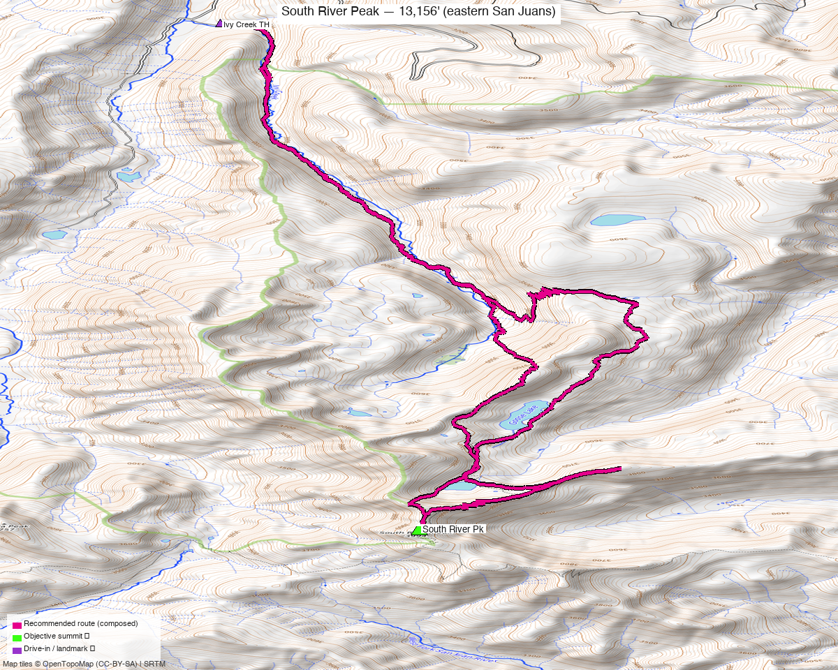
Note: the recommended route was distilled from 6 recorded GPS tracks of real trips (14ers.com · ListsofJohn · peakbagger) — all layered on the interactive CalTopo research map.
The peak
A long, gentle day up the Ivy Creek Trail (FDT 805) — easy Class 2 tundra and talus once you're high, but the trail approach is the real work: ~11 mi each way from the Ivy Creek Campground trailhead. Realistically a big single push for the very fit, or a comfortable overnight with a camp high in the Ivy Creek basin.
| South River Peak | |
|---|---|
| Elevation | 13,156' |
| Lat / Lon | 37.5739, −106.9816 |
| Route | Ivy Creek Trail → NW slopes |
| Class | 2 |
| CO rank | #522 |
| listsofjohn.com | 657 |
| peakbagger.com | 16516 |
Recommended route — Ivy Creek Trail from Ivy Creek Campground ⭐
The composed line follows a recorded Ivy Creek track that summits and starts at the trailhead — ~22.1 mi · ~5,040 ft, Class 2.
Route sequence
- From the Ivy Creek Campground TH (~9,290'), take the Ivy Creek Trail (FDT 805) south, climbing steadily up the Ivy Creek drainage through timber into the open upper basin below the Continental Divide.
- Leave the trail below South River Peak's NW side and climb grass and talus slopes to the broad summit — Class 2 throughout, easy route-finding.
- Reverse the approach. A tundra-and-talus walk-up start to finish; no scrambling.
Getting there — Ivy Creek Campground TH
| Drive from Boulder | ~5h 30m via Google Maps — via US-160 to South Fork, CO-149 toward Creede, then the Rio Grande / FR 520 → FR 523/526 to the Ivy Creek Campground. |
| Trailhead | Ivy Creek Campground / TH, ~37.6821, −106.9994, ~9,290' — the Ivy Creek Campground Road (FR 526.1A) is unpaved but good; passenger-car accessible. |
| Access corridor | Ivy Creek Trail (FDT 805) south up the drainage. |
| Land | Rio Grande NF / Weminuche Wilderness — no permits/fees, foot/stock only above the trailhead. |
Gear & season
- Best window: July–September — high, deep-backcountry San Juan; the long approach and upper basin hold snow into early summer.
- Terrain: Class 2 tundra/talus, no technical sections — the challenge is mileage and altitude, not difficulty.
- Storms: you're a long way from the car — start very early, or camp high in the Ivy Creek basin and summit on a short morning.
- Cell: dead, deep wilderness — InReach essential.
Other considerations
Consider a backpack ⛺ — at ~22 miles round trip, this is a natural overnight: an easy pack-in up Ivy Creek to a basin camp turns a big push into a short summit morning, and leaves time to wander the Continental Divide crest nearby.
Trip reports & GPX (all three sources swept)
Sources confirmed logged in: 14ers.com ("Basin"), listsofjohn.com ("letsgocu"), peakbagger.com ("Kyle Knutson"). 5 useful tracks — 2 from listsofjohn trip reports, 3 from peakbagger ascents; all confirm the Ivy Creek approach. All layered on the research map; recommended route magenta.
listsofjohn.com — the recommended line is a 22.1-mi Ivy Creek round trip (14413); a 23.1-mi variant (140) covers the same approach.
peakbagger.com — 3 ascent tracks (22–27 mi), all up Ivy Creek from the campground.
14ers.com — one library track through the zone is a ~95-mi CDT-style thru-hike that only passes near the peak; used for corridor context, not the route.
Sources checked: 14ers.com · listsofjohn.com · peakbagger.com · climb13ers.com