Whitehouse Mountain + "Corbett Ridge" + Mount Ridgway — a Sneffels-Range loop above Ouray (Class 3)
Other climbers: Emily Sharpe — not yet · Shawn D Keil — not yet
At a glance — recommended day
10 mi · 5,483 ft gain · Class 3 · 3 peaks · ~8.54 h drive
NOAA weather link: Ouray / Sneffels Weather
CalTopo research map: https://caltopo.com/m/DAS9GV2
Researched: 2026-07-31
Status in Peak Checklist: all three unclimbed.
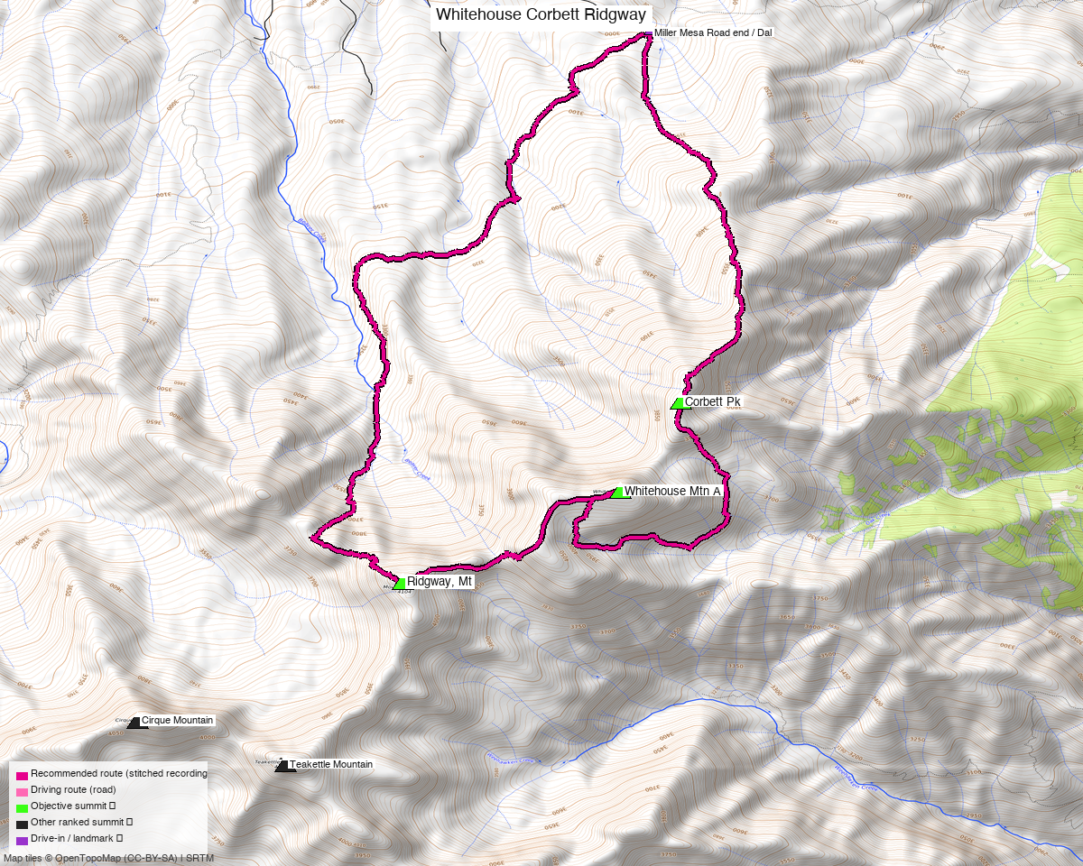
Note: the recommended route was distilled from 14 recorded GPS tracks of real trips (14ers.com · ListsofJohn · peakbagger) — all layered on the interactive CalTopo research map.
The one thing to get right: the approach is from the NORTH
These three sit on the ridge directly above Ouray, and the obvious-looking approaches are the
wrong ones. Camp Bird Road and Yankee Boy Basin are the famous access to this range, but from
there you reach Whitehouse and Ridgway only — a 14.4 mi round trip that never touches Corbett
(trk_loj_11064).
Every recorded party that got all three in a day started somewhere else: the end of Miller Mesa Road (FS 852), on the north side, at 9,815'. Three independent round trips begin within ~100 ft of each other there, and all three walked the same order.
The road is the crux of the logistics, not the climbing. OSM tags Miller Mesa Road
surface=dirt, 4wd_only=yes, smoothness=very_bad, and the trip report that named the
trailhead says "High Clearance required". There is no mapped trailhead node and no mapped parking
— parties simply park at the road's end, where Dallas Trail 200 begins.
Peaks covered
| Peak | Elev | LoJ class | Note |
|---|---|---|---|
| Whitehouse Mtn A | 13,500' | 2 | |
| "Corbett Ridge" | 13,107' | 2+ | peak_db calls it "Corbett Pk" and says Class 2 |
| Ridgway, Mt | 13,481' | 2 | alt name "S 2" |
Ouray County — Uncompahgre National Forest.
Class 3, and peak_db says Class 2
The summit grades above are not the grade of the day. The party whose track this route is built from recorded "Max difficulty: Class 3" for this exact circuit: a short section of Class 3 scrambling through a cliff band at ~12,600' on Corbett, and a summit block whose direct north approach "wasn't feasible" — they skirted east on a loose ledge system until the climbing eased. A second party calls the Whitehouse–Ridgway ridge "slow ridge travel". Helmet. Treat the published Class 2 on peak_db as wrong for this route.
The recommended route — 10.0 mi / 5,483 ft
A genuine loop from the Miller Mesa Road end, stitched from the best recorded segment for each leg across three parties' recordings (no two legs share more than 25% of their ground):
| Leg | Distance | Source |
|---|---|---|
| TH → Ridgway | 4.44 mi | trk_loj_209 |
| Ridgway → Whitehouse | 1.24 mi | trk_loj_4320 |
| Whitehouse → Corbett | 1.93 mi | trk_pb_1 |
| Corbett → TH | 2.43 mi | trk_loj_209 |
Roughly 1.9 mi of out-and-back excursions were trimmed out of the source recordings — those parties were also collecting "Angel Knob" (12,583') and "Reconnoiter Peak" (12,993'), which are unranked and not objectives here. If you want them, they are cheap add-ons from this same line; note that Steve Knapp's report warns the Ridgway → Reconnoiter descent "should not be taken lightly, it was quite dangerous", so that one is not a casual extra.
Direction — this line runs opposite to the recorded parties
Every recorded party walked Corbett → Whitehouse → Ridgway. The composed line runs the loop the other way, Ridgway → Whitehouse → Corbett, because that direction measured shorter for the same ground. The ridges are identical either way, but the Corbett summit block is not symmetric: the party that did it uphill found the direct north line unfeasible and skirted east on loose ledges. Doing Corbett last means meeting that ground on the way down. If that sounds worse to you than the mileage is worth, walk it the recorded way — Corbett first, Ridgway last — for the same distance and gain.
Expect it to take longer than the numbers suggest
Steve Knapp logged 11 mi / 7,000 ft in 12 hours on a slightly bigger version of this day and wrote that "the hike took longer than the stats would indicate — some tough bushwhacking in the trees and slow ridge travel." The lower half is trees with deadfall; the upper half is loose talus. This is a 10 mi day that walks like a much longer one.
Getting there — Miller Mesa Road end
| Drive from Boulder | ~8h 35m via Google Maps — 354 mi. The trip report that named the trailhead cites ~6–6.5 h from Denver, so treat the routing estimate as conservative. |
| Trailhead | End of Miller Mesa Road (FS 852), 38.0538, −107.7360, 9,815' — also the trailhead for Burn Hut and the Dallas Divide trail. No mapped parking area; park at the road end where Dallas Trail 200 starts. |
| Road | High clearance required. OSM: surface=dirt, 4wd_only=yes, smoothness=very_bad. Verify current condition before committing — this drive is far too long to discover the road is closed. |
| Land | Uncompahgre National Forest. Six landuse=winter_sports polygons sit near the lower road (Miller Mesa Nordic and others); none touch the route. |
Gear & season
- Best window: July through September. The only winter recording in the pool (
trk_14ers_3, January) was rejected for route-building. - Terrain: Class 3 crux on Corbett; loose talus and slow ridge travel throughout the upper half; bushwhacking with deadfall in the trees below.
- Helmet: yes — loose rock on the ledges and ridges.
- Vehicle: high-clearance 4WD.
- Cell: unreliable; carry a satellite messenger.
Other considerations
This is an 8.5-hour drive for a 10 mi day. There are 22 unclimbed ranked 13ers within 10 mi of Ouray, though none of them share Miller Mesa Road — they sit in the Yankee Boy, Red Mountain Pass and Telluride drainages. The nearest is Hayden Mtn South (13,211', 4.9 mi away, off US 550). Worth building this into a multi-day Ouray trip rather than driving out for one loop.
Trip reports & GPX (all three sources)
All three sources swept across all three objective peaks and deduped, plus the mapped OSM trail network — all layered on the research map.
- 14ers.com: peaks 10381, 10563, 10393 — 5 GPX-library tracks.
- listsofjohn.com: peaks 325, 715, 342 — 4 tracks from 17 trip reports (plus 2 duplicates of another source). LoJ also cross-verified the peakbagger ids: 15123 / 85983 / 15368.
- peakbagger.com: peaks 15123, 85983, 15368 — 5 ascent tracks with GPS (plus 7 duplicates).
Sources checked: 14ers.com ✓ · listsofjohn.com ✓ · peakbagger.com ✓